 Click on picture for Dale Ireland's time lapse movie of today's action.
Mt. Hebo, Oregon 3160 ft 96 mph!!!
HURRICANE Ridge 5200 ft 92 mph (there is a reason they call it hurricane ridge)
Mission Ridge 6739 ft 90mph
Humbug Mt. 50 ft 83 mph
Cape Foulweather 1024 ft 81
Garibaldi 75 ft 79mph
Cape Disappointment 140 ft 77
ANTELOPE (eastern Oregon) 6460 ft 77
Cape MEARES 1421 ft 75 mph
Pretty impressive for late March.
But the other story was the substantial instability of the air coming in off the Pacific and convective showers (some very intense) it produced. I got savaged by one on the way home. I knew it was coming from the radar and delayed five minutes too long. I really enjoy cutting it close, attempting to race ahead of an ominous, dark cloud mass.
An important measure used by professional meteorologists to measure instability is called CAPE, which stands for Convective Available Potential Energy (now that will impress your friends). It is related to the most of energy that will be released by a buoyant parcel of air in a column. Here is the forecast CAPE for this afternoon:
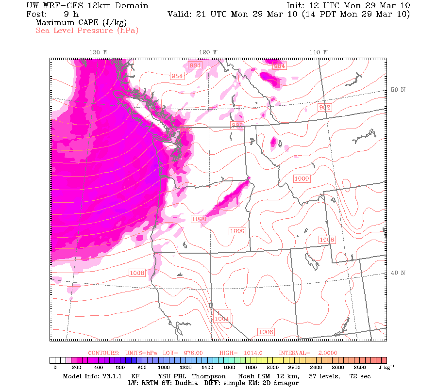 Values of up to around 600 offshore with modest values into western Washington. This is good for us...but in the midwest they can get to 3000+. The instability of this air flow is associated with relatively cool air aloft moving over fairly warm water and the heated land. In fact, the greatest instability in our areas tends to be in spring.
Instability leads to convective clouds (e.g., cumulonimbus) and isolated heavy rain and occasional lightning. Take a look at the radar image this afternoon below--some of the showers were very intense (the yellows). You don't bike in yellows. You don't want to know about the reds.

Here is the high resolution visible satellite imagery at roughly the same time. Can you see the instability showers offshore..with the block being the clearing between the cumulus cells. Showers and sunbreaks...a NW classic. This is exactly the kind of pattern that lays down lots of snow. Below is the forecast 24-h snow amounts ending 5 AM Tuesday morning...some locations get well over a foot. City Light should think about revoking their electricity surcharge.


And if all of the above is not enough...there is a high surge advisory along the coast:
A HIGH SURF ADVISORY REMAINS IN EFFECT UNTIL 6 PM PDT TUESDAY.

LARGE SOUTHWEST SWELLS OF 20 TO 24 FEET WILL CONTINUE TO AFFECT
THE NORTH AND CENTRAL WASHINGTON COAST THROUGH TUESDAY AFTERNOON.


Driving to Neah Bay this morning caught in a huge hailstorm -- and yes, the waves looked like they were going to come through the side windows.
ReplyDeletePronounced rainshadow E of Mts. today. Got .02, GFS showed .04, way off!!
ReplyDeleteThat CAPE value chart is one of my favorites.
With calmer winds and colder air aloft tomorrow, I might do some local cloud chasing if those dip'n dots snow showers form and get some cool pics.
Thanks to Dave for his time lapse; it was so beautiful! Thank you for sharing too, Cliff.
ReplyDeleteQuite a little storm....BTW have you all seen this new article in the NYTs about the conversation between climatologists and meteorologists...rather interesting (http://www.nytimes.com/2010/03/30/science/earth/30warming.html?ref=science)
ReplyDeleteYou may have already saw this times article but I thought you might be interested:
ReplyDeletehttp://www.nytimes.com/2010/03/30/science/earth/30warming.html?ref=science
We got a pile of hail Monday afternoon in and around downtown Renton. It looked like December snow! About an hour afterwards, it was nearly all gone from the additional rain melting it away. Sure was pretty for a while though.
ReplyDeleteRE: NYTimes article: TV weather forecasters are a bunch of meteorologist wannabe's. What do you expect from that bunch?
ReplyDeleteIt's been a fun day on Copalis watching the rain squalls blow through--sometimes with bright sun behind them. Good rainbows to the east.
ReplyDeleteAs for the Dot Earth bit on Meteorologists vs Climate Scientists--it has to be one of Revkin's low points. The jerks he shows are TV weathermen--hardly meteorologists. Cliff is a meteorologist--one you can believe whether it's weather or climate.
Paul
Cliff,
ReplyDeleteWas looking at the 28km Infrared satellite this evening and noticed something way out west in Siberia. It is obviously a large low pressure system but the greenish color really stands out....it kinda looks like a mermaid tail or at least something with a tail. It just caught my eye and peeked my curiousity.
Soupman
I don't think all this cool and wet (besides wild) weather was what the NWS forecaster had in mind with their April outlook first done on March 18, which had the Pacific NW as drier and warmer than normal. I now see they've revised April to being more than likely cooler and potentially wetter than normal.
ReplyDeleteSadness reigns.