The central pressure is roughly 945 hPa--similar to a category three hurricane, and in fact this storm does have hurricane-force winds. (a hPa is the same as a millibar, mb, which you may be more familiar with. In the inches of mercury units this would be 27.9 inches). Take a look at a recent National Weather Surface surface analysis (for 4 PM Tuesday). 943 hPa low center and the NWS folks note the hurricane-force winds (sustained winds of 64 kt or more). That is a lot of isobars, with extraordinary pressure gradients.


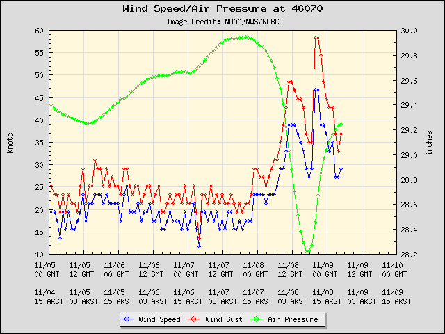
This storm is far deeper and stronger than the famous "Perfect Storm" of movie fame--at its most intense that low only got down to 972 hPa...nearly 30 hPa higher pressure. The has passed near a few weather buoys. Here are a few samples. Buoy 46070, found in the western Bering (see map) had a minimum pressure of 28.2 inches of Hg (954 hPa) and gust to nearly 60 kts.

Or Buoy 46035 (to the east) with gusts to 75 knots!

Wave heights at these locations climbed above 35 ft:


The fact that the storm is moving so quickly is preventing the waves from getting catastrophic since big waves requires strong winds, large fetch, and duration to build. Coastal flooding (up to 10 feet storm surge) and blizzard conditions add to the mix. In any case, this will be one of the great storms of the year.
Selected Peak Gusts from the NWS Hydrometeorological Prediction Center
.SELECTED PEAK WIND GUSTS IN MILES PER HOUR

...ALASKA...
TIN CITY AFS (AWOS)                   85
WALES                                 84
CAPE LISBURNE(AWOS)                   75
KOTZEBUE/RALPH WIEN (ASOS)            73
KIVALINA ARPT                         71
POINT HOPE (AWOS)                     69
CAPE ROMANZOFF (AWOS)                 60
ST MICHAEL                            58
TELLER                                58
EMMONAK                               56
NOME (ASOS)                           55
BETHEL AIRPORT (ASOS)                 54
SAVOONGA AIRPORT                      54


Will it come our way next, Cliff?
ReplyDelete60 hPa in 48 hours? Wow... is that a record pressure drop for 48 hours in an extratropical cyclone? The isobars also look really packed towards the low. This storm covers a huge area, but it seems to have an especially compact pressure gradient near the low.
ReplyDeleteI hope all our fisherfolk are safe from this rapid storm event.
ReplyDeleteI look forward to learning how our weather might be impacted by this system
Sysiphus, the intense low that Dr. Mass refers to is moving north into the Arctic and won't affect the Pac NW. However, this large storm is expected to spawn a new low (which is quite common) over the Aleutians and that will move our way. It will bring western WA rain on Friday. This new low will be well up north in BC/Alberta and only have a central pressure of 992 mb/hPa, so nowhere near the strength of its parent low.
ReplyDeleteI lived in the region in the 70's and experienced -50 degree temps and 66 knot winds. A short trip outside is an adventure I would not like to repeat. Wishing my friends there all the best for a safe passage.
ReplyDeleteIs there any way for the NWS and the meteorological society at large to give nomenclature or designation to these extra tropical cyclone and a corresponding level of threat like the Saffir-Simpson scale?
ReplyDeleteWe all know they are extremely dangerous and are in fact worse than many hurricanes.
It seems as though the public's perception of the dangers may be decreased because extra tropical depressions or cyclones do not get the public's attention like the term "hurricane".
I have to say 60 hPa in 48 hrs. wow! not a lot of time to warn the public.
+1, Irony. Funny that the title of the immediately preceding article was, "Boring, with a hint of la Nina"
ReplyDeleteHere's some real-time reporting... this one has lived up to the hype, unfortunately: CNN News Blog
ReplyDeleteI hope nobody gets killed.
Anyone know where Dr. Mass got this sat image? http://2.bp.blogspot.com/-F-nAIn9d-K0/TroYTBMqlPI/AAAAAAAAFR0/CvNkL_Lai9Q/s1600/4abf.jpg
ReplyDeleteI've looked on the various satellite imagery websites without success. Seems most satellites don't point that far north.
This is certainly an impressive storm, with a < 945 hPa central pressure and recorded wind gusts near 90 mph. We occasionally see storms of similar strength impact coastal Washington and B.C. Why is this type of storm so unusual in northwestern Alaska? What factors prevent strong storms like this one from impacting very high latitudes on a more regular basis?
ReplyDeleteOne place to get this satellite imagery is at the NWS Alaska Region website: http://www.arh.noaa.gov/index_sat.php
ReplyDeleteFascinating Cliff, especially in light of our recent reminiscing about the Columbus Day storm. I suppose the colder waters and air temperatures make large storms like this unusual so far north. But smaller "polar lows" can be very intense with very high winds.
ReplyDeleteReuters article about the storms talks about the lack of sea ice making this storm so much more dangerous to the people living in the coastal towns and villages.
ReplyDeletehttp://www.reuters.com/article/2011/11/10/storm-alaska-idUSN1E7A82DG20111110
I am riding the sounder up from Tacoma and see what looks like a lenticular cloud by Rainier but from my perspective it is displaced by several miles to the north east of the peak. Is this possible?
ReplyDeleteBrings back memories of my days on Bering Sea Fisheries Patrols in the Coast Guard. I was younger then. Scary though, even in a 213 foot Coast Guard Cutter.
ReplyDeleteHey Cliff,
ReplyDeleteCheck out these guys.
http://www.kickstarter.com/projects/jackadam/dark-sky-hyperlocal-weather-prediction-and-visuali?ref=NewsNov1011&utm_campaign=Nov10&utm_medium=email&utm_source=newsletter
Might be worth contacting them.
Wow - a real "storm of the century", but not occurring somewhere in Maine it loses that dramatic impact.
ReplyDelete