 |
| Picture Courtesy of Adam Foster During the Early AM on July 9 |
To be fair, my colleagues in the NWS did talk about thunderstorms over the Cascade crest and eastern Washington, and the models did suggest a northward propagating feature that forced them--- but lets be honest here, we simply did not expect the extraordinary lightning show, heavy rain, and hail that struck many around western WA. And this kind of failure has happened many times in the past. And there will be more in the future.
Let me show you a sequence of radar images during the period of biggest action over Puget Sound--for 11 PM, 1 AM, and 2 AM. The reds are pouring rain or hail (or both!). A really strong cell moved from the foothills near Enumclaw and moved over Bainbridge Island before heading northward.


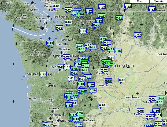
The rainfall totals varied wildly, with some folks getting over half an inch (see map)
Some of the early signs of potential convection were obvious last night...did you notice the development of mid-level shallow convection before and around sunset? Click on the picture below to see a wonderful video of this phenomenon (again provided by Adam Foster):

In fact, the infrared satellite image at 8:45 PM shows an east-west line of convection to the south...and if you looked at an animation you could see it was moving northward. East of the Cascade crest was surely going to get in, but what about the west?
 |
| 8:45 PM satellite image |

The UW high-resolution WRF model (1.33 km resolution) starting at 5 PM in fact did a bit better, but not good enough:


Forecasting convection is very difficult for many reasons. Thunderstorm initiation is complex and highly sensitive to the 3D conditions of the atmosphere. Our models generally lack the resolution to simulate them directly and our kludgy methodology for attempting to do so (cumulus parameterization) is relatively crude. And many more...
SUBMIT YOUR WEATHER PHOTO FOR THE 2013 WASHINGTON WEATHER CALENDAR
The UW AMS Student Chapter is partnering with KING 5 News to create the 2013 Washington Weather Calendar. A photo contest is OPEN and I would like to encourage everyone to submit your best weather or nature photos of Washington State. There is a *$200 cash prize for the winning cover photo* and winning monthly photo entries will receive a free calendar. The deadline to submit photos is July 31st. As the charitable partner of the project, the UW AMS Student Chapter will receive a portion of the proceeds from the calendar sales.

*To submit photos and for more information, please visit this website*:
http://www.king5.com/community/Submit-a-photo-for-the-KING-5-Weather-Calendar-160272225.html


Down here near Sumner we were really enjoying the lightning show sometime between 11:30pm and 12:30am. In the valley we weren't seeing lightning strikes - we were getting lightning that appeared to be crawling along the undersides of the clouds! It was beautiful and amazing - I've never seen that happen consistently, but it was happening over and over last night.
ReplyDeleteI thought about getting my camera and tripod, but I really didn't want to miss the show.
BTW some of these new-style captchas are getting very difficult for a person to discern. I've got friends who do AI, and captchas have now lost the battle - they have to be almost impossible for a human to read before they'll puzzle a bot! Since comment moderation is on, I'm not sure what the captcha is accomplishing anyway.
A brillant thunderstorm line rolled thru Yakima around 8pm. Boarderline severe. Nice shelf cloud, dust gust front. A few strong cloud to ground strikes, but it was non stop cloud to cloud.
ReplyDeleteI was hoping for a strike total?
Anyway, it was weird because Sunday was the hottest day we've had in a couple years. 107 in Ellensburg and a few hrs later that. And it poured rain. Yakima reported 0.00 but power was knocked out to the entire city. No way could that be correct.
Got a once in a lifetime shot out my front window in Eburg from this storm.....it only took me 41 years and it was like a Jordan McDonald's commercial....in the house, through the front window, finger at the ready, good intuition, just in the right spot, a lot of luck with a cell phone!
ReplyDeleteduh...should have added the pic link https://twitter.com/#!/thompsonized/media/slideshow?url=pic.twitter.com%2FprQSl1C6
ReplyDeleteCliff, is the ground-level haziness seen yesterday and today in Seattle (probably elsewhere too) at least partly comprised of the Asian forest fire smoke? To me it has a slightly "smoky" look.
ReplyDeleteI was right at the right spot for once! I was in my sailboat anchored off Blake Island when a thunderstorm rolled through about 1:00 AM Monday. Not quite as intense as the Eastern variety, but there was a goodly amount of thunder and lightnig and about a 5-minute cloudburst. Not sure that the rig was grounded, I put a chain oround the mast dangling over the side and into the water as the storm began, just in case I got a direct hit, but according to my counts the lightning was 2-3miles away.
ReplyDeleteMy kids were camping in the backyard while I lay awake fearful. I said to DH, it's raining! He says, dont' worry, the tent is under a tree. Great...my kids are under a tree in a lightning storm! The lightning was a few miles away but still. Only one kid even heard it.
ReplyDeleteI noticed those evening clouds, and thought they might signify a thunderstorms were on their way. Then I forgot about it and went to bed. Dreamt I was outdoors walking around and a thunderstorm was coming in, one with lots more thunder/lightning than the one or two strikes that the normal wimpy Northwest t-storms have.
ReplyDeleteEventually, the thunder woke me up and I realized it wasn't just a dream. Good light show even if it did disturb my sleep.
Was waiting for these to come by in the mtns! Instead they parked right outside the yard. We live in Edgewood, just above SR 410 and 167. Nice light show for puget sound!
ReplyDeleteLight Show
Captured from deck as storm tried to approach!
Hey Cliff,
ReplyDeleteCheck out this video my brother captured. Unaltered, real time footage. Absolutely amazing...
http://www.youtube.com/watch?v=hVLnkcH70Kg
"Forecasting convection is very difficult for many reasons. Thunderstorm initiation is complex and highly sensitive to the 3D conditions of the atmosphere." I really to this statement of yours. Very informative and interesting idea.
ReplyDeletePhilippine Storm
I'm wondering about the murk in the air too. It is definitely humid (for western Cascadia in the summer) but it is more than that. Thinking either the Asian smoke or general smoke-haze-particulate from points south and east in the intermountain west, given all the fires (now including SE Oregon) and the southerly (even Monsoonal) wind pattern that brought up the moisture and enabled the T-storms.
ReplyDelete(Agree also with the person who said the comment security thingy is getting almost impossible to read.)
I have an unrelated question and I tout I'd turn to this group for help:
ReplyDeleteWhy is it that there are 16 hours of daylight during the summer solstice (based on 6/20/12 sunrise at 5:11 sunset 9:11) and 15 hours and 34 min of night at the winter solstice (based on 12/22/11 sunrise at 7:54 am and sunset at 4:20 pm)? What is the reason for the inconsistency? In my search I've read a little about axial tilt and refraction but don't know if I'm barking up the wrong tree. Thanks in advance for any help pointing towards further understanding!
Because day starts when the disc of the sun touches the horizon and ends when the last bit of it passes the horizon. The sun is not just a point, so this takes a few minutes.
DeleteIn response to the question asking about the haze, there is an msnbc article on it today http://usnews.msnbc.msn.com/_news/2012/07/10/12666655-from-russia-with-love-siberian-wildfire-smoke-means-rosy-sunsets-in-seattle?lite
ReplyDeleteDrew, the earth is moving faster in its orbit during our winter solstice as compared to our summer solstice.
ReplyDeleteThe earth's orbit is not completely symmetrical around the sun. During northern summer, we're actually further away from the sun than during northern winter.
Another side-effect of this is that, while the winter solstice is the "shortest day" of the year, the progression of sunrise times and sunset times does not reverse on that day. Our earliest sunset occurs roughly December 12, but the sunrises continue to get later until around early January.
Hi, again, Cliff,
ReplyDeleteWho cares if you can/cannot forecast the occasional thunderstorm during Seattle's PEAK GREAT WEATHER MONTHS?
I don't.
I love this weather. Who would not?
Summer has arrived in the Puget Sound area. Nothing finer on the face of the earth.
You people do a GREAT JOB. The forecasts are much improved despite the nay-sayers. Really.
I just wish that you forecasters would miss more often when lousy, cool June weather is forecast. Unfortunately, you usually nail the cool weather. LOL.
I very much enjoy your blog. Every line of it.
Thank you,
Rod
This comment has been removed by the author.
ReplyDeleteCliff, my various weather gizmo's and forecasting experience up here in the Puget Sound area point towards us seeing Isolated T-Storms develop rapidly after maximum heating Thursday afternoon.
ReplyDeleteI'll check again in the morning, as the models & their products have been admittedly schizo all week, but I'm calling for rapid formation over the central Cascades and a steady N-NW advection towards UW!
-AG2 Tom Jenkins, USNR
Thanks Thompsonized...but if I understand correctly Cliff was talking about smoke higher up in the atmosphere. I'm asking about the ground-level haze of the past few days. Does that have a smoke component too?
ReplyDeleteIf it does, I'm surprised it's not getting more coverage.
Weatherologist,
ReplyDeleteI don't believe Drew was asking why winter days are shorter than summer days - he was asking why the daylight duration of our longest summer day is not identical to the night duration of our shortest winter day.
I'll take a crack at it, even though I'm only an amateur astronomer.
ReplyDeleteThe earth follows an elliptical orbit, with the sun at one focus of the ellipse. The earth travels through space more quickly when it's near the sun and more slowly when it's farther from the sun. The length of the solar day (the time the sun is above the horizon) depends both on the earth's 24-hour rotation around its axis, which doesn't change with the seasons, and the earth's speed through space, which does change with the seasons. The earth is closest to the sun on January 4th, so northern hemisphere winters have slightly shorter days.
I should add that the earth's orbit is only slightly elliptical so it doesn't make a huge difference. The earth being closer or farther from the sun is not what causes seasons, what causes seasons is the earth's tilt of 23.5 degrees being toward the sun in summer and away from the sun in winter.
Thunderstorm at the north end of the sound has been going on for about 6 hours!
ReplyDeleteJuly 13 in Port Townsend - woken by thunder around 3:30 am, still going on six hours later!
ReplyDeleteJuly 13 at Port Townsend: woken by thunderstorm at 3:30 am that is still going on 6 hours later.
ReplyDelete"Heck with all that", ... If I may Cliff. ..... What about what's going on more specific at, this point, West to East - "of the Rockies", .... "colder", to hotter. ? (!!)
ReplyDelete