
We have warm, humid area over us now, with many dew points at 60F and above....that is why it feels kind of sticky.

The clouds and precipitation is cooling western Washington, but temperatures are surging over the Columbia Basin--some folks are already over 100F. Expect many temps above 105F, some reaching 110F

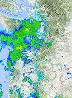
These showers are just the first line, more will come later...here is the 24 hr precipitation ending 5 AM Monday. Not used to seeing precipitation around here! But with the rain will come lightning and the potential for new fire starts.

Serious fire threat.


Down here in Chehalis rain and thunder (saw only one flash) started in the early mid-morning. Temperature went down a few degrees and RH up (about 70 now), temperature is now back up to 68.5 (11:30am)
ReplyDeleteNOhting's been able to organized and make it to Poulsbo... yet. Clouds/moisture are really moving fast, too fast to build up?
ReplyDeleteDid the NWS miss this? This AM they were talking about evening TS maybe in the lowlands and quickly stabilizing after that.
ReplyDeleteAnd here we go.
ReplyDelete"In spite of the combination of weather and dry conditions experienced by firefighters on the Paradise Fire, Saturday was a relatively quiet day. The fire continues to advance up the slopes of Pelton Peak, while other portions of the fire saw little growth. Crews continue to work to keep the fire north of the Queets River. High temperatures on the fire ranged from 89-94 degrees F, which is considered quite high for this time of year. No significant rainfall is in the forecast, and there is a chance of thunderstorms and potential for dry lightning on Sunday.
"If this fire were happening in August or September we would be much less concerned about it than we are here in June" said John Giller, Operations Section Chief with the Incident Management Team assigned to the fire. "There is a lot of fire season ahead of us." On Saturday a paramedic was embedded with the on-site crews as fire officials continue to provide for firefighter safety as a top priority."
http://www.nwccinfo.blogspot.com/2015/06/paradise-fire-daily-update-for-june-28.html
Homes have been lost in Wenatchee tonight. Last I heard (10:00 PM) fire was at 1700 acres and still moving. It's going to be a long summer for those poor folks who lost their homes. And many others.
ReplyDelete