And the snow forecast for Monday is no different.
Whenever air is coming off the relatively mild (roughly 50F) Pacific, it is difficult to get lowland snow unless the air is very, very cold aloft.
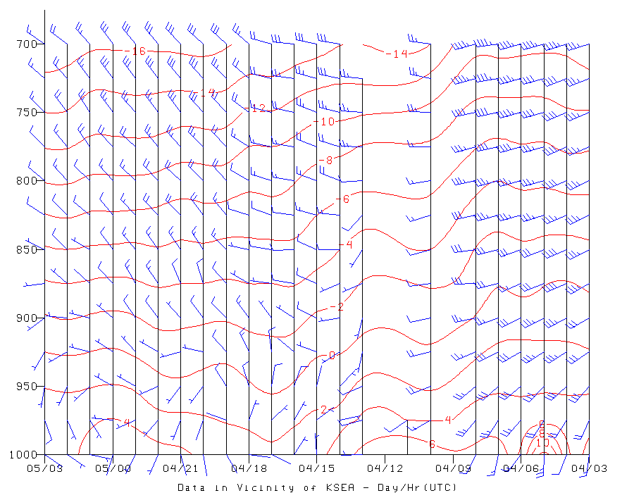
As scheduled, a strong cold front moved through this morning with cool onshore flow in its wake. This transition was clearly shown in the winds and temperatures over Sea-Tac Airport (see time-height cross section below, red temperatures, blue are winds, time goes from right to left in GMT/Z/UTC, and heights are in pressure --850 is roughly 5000 ft). The wind shifted around 0412 (Dec 4 and 12 UTC-4 AM) and the temperatures dropped.

Picture taken by Rob Nelson
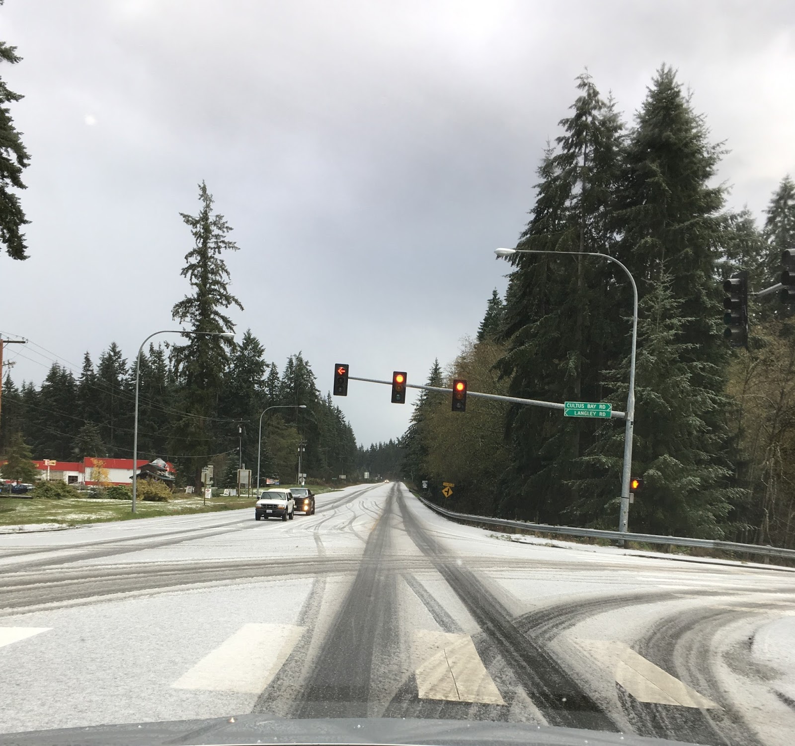
Or Ken's Korner on Whidbey Island:
Picture courtesy of Susan Kieffer
The current snow threat is associated with cold unstable air that is being lifted by an upper level trough (or disturbance). The latest infrared satellite image Sunday night show the convective showers associated with the unstable air (the white mottled look). An area of enhanced showers is off our coast and headed our way overnight--that is the immediate threat.

But although the air has cooled considerably, it is still marginal for snow near sea level and near the water. In fact, the freezing level rose a bit during the day and is now (7:30 PM) roughly 2200 ft. Keep in mind that the snow level (the level below which the precipitation is all rain) is about 1000 ft below the freezing level (the altitude of 0C). Thus, the snow level is now around 1200 ft.

The NOAA/NWS HRRR (High Resolution Rapid Refresh) snow total through noon shows only .1-1 inch over most of Seattle, but much higher amounts south of Olympia and the Olympics.

The even higher resolution UW model run for the 24-h snow ending 4 PM Monday is similar, but with more snow over Snohomish County and north Seattle (few inches).

The marginal (and thus uncertain) nature of this event is highlighted by the latest National Weather Service SREF ensembles for snow at Sea Tac (452 ft). The mean total snow is around 3/4 of an inch, but there is a lot of variability.

The Seattle media has already started its favorite past-time, with "live storm coverage" and it is starting to have an impact on local supermarkets (see below).

And if you think the snow will be over tomorrow...think again. Much colder arctic air will surge southward Tuesday morning, with potential snow in Sequim/Port Angeles and even northern Puget Sound.
____________
New Weather Smartphone App, uWx
At the UW, we have developed a wonderful FREE weather app for Android smartphones that also collects pressure for use in weather forecasting. If you want to try it, please go to the Google PlayStore and download it.
At the UW, we have developed a wonderful FREE weather app for Android smartphones that also collects pressure for use in weather forecasting. If you want to try it, please go to the Google PlayStore and download it.


Very cool line of showers in the middle of the Juan de Fuca Strait. Visible in radar, and present in the 1 1/3 km WRF/GFS 0 UTC run at 10pm PST. Verifying at my house where graupel and slush are currently falling at sea level while just inland it's dry. I'm hoping that model continues to be accurate as it's putting a bull's eye of accumulation near the town of Sooke where I live. I'm hoping for a work from home snow-day tomorrow.
ReplyDeleteNot all Android smartphones can collect pressure for use in weather forecasting. My LG-K8V can not...
ReplyDeleteAt 7:50 am roofs, lawns, and the driveway are white here, at Olalla just uphill from SR16 at Burley Olalla Rd. The stuff falling is small and coming fast, as though it has partially melted on the way down. Just as I wrote that it's changed to more normal-looking snow that's sticking to trees. Temperature's 35F on my porch.
ReplyDeleteOn the hill in Button on Vashon Island wet show falling for about an hour, sticking a bit. My daughter down on quartermaster has only rain.
ReplyDeleteAlways the same story- too dry or not quite cold enough. I hope we get snow in the convergence zone where I live. But there was a teaser with some graupel yesterday around 11:00 AM when the cold front passed.
ReplyDeleteYup. Lived here for 40 years and it's usually disappointment after disappointment. Maybe every 10-15 years we get a doozy, and even then it doesn't last all that long.
DeleteStill waiting to see what happens with the CZ thats been forecasted to develop tonight. It's shown in the south, at the Sno/King line and north in Sno/Skagit line. If it develops it looks like some are going to be the snow lotto winners.
ReplyDeleteCliff- I need to commute back and forth from Redmond to Bellingham on Tuesday & Wednesday. Any hunch on the ability to make it?
ReplyDeleteI can't recall how many times this scenario (cold air coming down out of the Frasier River Valley to set up a CZ) has led to snow predictions in the last five years and not once has panned out. It has been numerous times. So as I sit here on a 500' hill in Lynnwood, I am not counting on it. However, I sure hope mother nature does not disappoint me yet again. Give me snow!
ReplyDeleteHi Cliff,
ReplyDeleteI am in downtown Vancouver BC and it is dumping snow right now. They got about 3-4 inches this morning and it really snarled up the traffic.
Looking at the obs, it feels like the arctic front will set up over S. BC this afternoon and then move south, with plenty of moisture to work with.
I wouldn't be surprised if this turns out to be a very snowy night for some people.
Kevin
Cliff - what's your take on Thursday? Scott Sistek said the GFS shows a powerful wind storm while the Euro shows 3-4 inches of snow. Do you have any idea, based on other models, what we might be in for? Wind or snow? Or both?
ReplyDeleteAny update?
ReplyDeleteI bet we see a strong gap or east wind event. With a slow moving low approaching and a very strong hi east of the mountains. Those have been the highest winds for us living down slope of the stampede gap.
ReplyDeleteWould love a mountain wave wind event! It's been quite a while since we've had a good one,
DeleteWhere's the beef? Uh, I mean ...where's the snow? I was hoping you would weigh in on all the hubbub today. 🙄
ReplyDeleteCliff, what has the UW got against iPhones?
ReplyDeleteI bet 95 percent of us in Western Washington experience a non-event this week which is very typical of brush with winter forecasts around here. I understand the difficulties and uncertainties but it's frustrating to the snow lovers! :) Maybe it was due to being a kid, but growing up in the 70s and 80s i sure think it used to snow a lot more in Seattle than it does anymore. Sigh.
ReplyDeleteQuestion - What is the longest snow storm drought in Pacific NW history? For much of the Puget Sound it has been nearly 5 years (January 2012) since the last real good snowstorm. We have had several Winters since then with virtually nothing.
ReplyDelete