___________________
Let me update you on the snow situation, using all the technology at my disposal, both using ensembles for a probabilistic viewpoint and high-resolution forecasts.
Let's begin by noting an important point: after the warmest November in Seattle history and mild temperatures the last few days, the road surfaces are quite warm, which will help melt any light snow falling on them. To illustrate, here is the latest air and road temperatures (road surface temperatures in rectangles) from the Seattle SnowWatch website. Most roads are in the mid to upper 40s. This will be a powerful weapon against icing during any initial onslaught of snow.

As in any good forecast we should start from a probabilistic viewpoint with a clear understanding of forecast uncertainties, and as I have discussed many times in the past, ensemble forecasts (using many forecasts, each a little different) is a powerful tool to do so.
The National Weather Service 21-member GFS ensemble's cumulative snow forecast for Seattle (below) has all members (forecasts) going for some snow this week (remember this is amount of snow falling out of the sky, not depth on the ground). Black is the average of the all the forecasts and blue is the operational high-resolution GUS run. As noted earlier, there are two possible events. The first, on Monday, produces about 1-2 inches and the late Wednesday/early Thursday event has a little more (but more uncertain).

The more skillful European Center ensemble system, with more ensemble members, higher resolution, and better physics is also showing snow in two steps (see below). About a quarter of its members suggest no snow, while the rest produce generally light amount (.5-1.5 inches). The second event is much larger with 3-6 inches for several members.

The National Weather Service also has a short-range ensemble system using two models (NMM and WRF) and higher resolution (about 16 km). This system shows a mixture of solutions for the first potential snowstorm, with a lot of uncertainty and about a quarter of runs showing very little snow.

So what is my take away from all this? There is uncertainty, with about 25% of the forecasts showing virtually no snow. Roughly 75% of the model runs are predicting an inch or two at Seattle-Tacoma Airport (452 ft). The temperatures on Monday are colder than we have had, but they are still on the margin near sea level and the water. So expect a substantial gradient with elevation (more on the hills).
To get a better spatial view of the snowfall, lets look at the UW WRF, which is driven by the NWS GFS operational model. Since the GFS solution is close to the mean of the ensemble and seems to have a representative solution, the UW ultra-high resolution view should be useful.
Here are the 24h snow totals from the UW 1.3 km domain (very high resolution in the weather business). First the 24h ending 4 AM Monday. Scattered snow showers, with heaviest lowland values south and southeast of the Olympics, which is not unusual with relatively warm snow events and southerly/southeasterly flow. Not much in Seattle--thus the Seahawks game should be fine. Some snow over SW Washington.

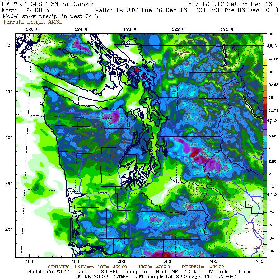
But the next 24 h, ending 4AM Tuesday is another story. The Puget Sound area gets a half to a few inches, with north Seattle to Everett getting more than the south Sound. Less near the water.
The 9-km European Center snow total through Monday evening shows loads of snow over the mountains (12-15 inches) and zero to a few inches over the lowlands (with much less near the water).

The bottom line of all this? Nothing is certain. But it appears probable (say at the 75% level) that much of the lowlands away from the water will see some light snow on Monday, particularly above a few hundred feet and over north Seattle and southwest of the Olympics.
We will leave the Wednesday event for another blog.


Cliff,
ReplyDeleteThank you.
I feel like I'm reliving the election of 2016. All this uncertainty.
ReplyDeleteSeems to me like a rather minor snow event coming;nothing too much to get excited about.On the other hand,the 12Z ECMWF seems to be indicating a major arctic air outbreak( 500 MB heights<520!)around the 13th of this month.It's too far out now to take it too seriously,but if the model pans out,a much bigger event will be coming than next week's one!
ReplyDeleteLet's hope so!
DeleteThank you Professor. Particularly those of us who played too much D&D as adolescents appreciate your probability assessments! Why.. i'll even estimate a probability of [throws odd shaped dice] 0.375 the Seattle Times et al will manage to excerpt this forecast and conclude: a small phalanx of goosestepping snow zombies are headed straight for us up the Chehalis Gap!!
ReplyDeleteHere's hoping we get at least a couple inches. It's been much too long since we had a decent snow!
ReplyDeleteWhere is Ray Ramsey when you need him! He used to love discussing snow possibilities with his rotating chalkboard!
ReplyDeleteAwesome soupman! Good ole Ray or Bob Cram
DeleteDon't forget your Oregon Fans!! Would have liked to see some Oregon maps for potential of Valley snow.
ReplyDeleteThanks Cliff
So great that you take the time to provide these comprehensive renditions Cliff! Much appreciated by we weather fanatics! Thank you.
ReplyDeleteWe did it! First snow walk of the winter here in SE Auburn this AM at approx. 550' elevation. After looking at the models yesterday, I told my wife not to be surprised if we work some kind of frozen precip. in the morning. And sure enough, about 8am I heard some sleet on the roof which then turned to snow by about 8:45am. Nothing super heavy, but enough to turn the bark and roof tops a slushy white. The result of cold air aloft moving in and dying convergence zone moving south east. Hope to see an even better repeat tomorrow morning! ;)
ReplyDeleteBtw, Cliff, is there any way you can get that deep low coming in on Thursday to come in about 200 miles South?!?! Really, that would be something.. Right about the Mouth of the Columbia River would be perfect! ;)
ReplyDeleteJust started following your blog. I'm from Chicago and Tom Skilling was the MAN there. You and Scott Sistek remind me of him. Love the detail you give. Especially after the non wind event couple weeks ago!
ReplyDeleteMe too, Marcus. I miss Tom Skilling and his wonderful Trib weather page. But Cliff Mass is a fine sub.
DeleteWell stated cliff!
ReplyDeleteSnow and cold are costly and destructive for me. Being prepared is key to limiting losses.
Thanks
Thanks for mapping up into BC. We find your forecasts and blog useful too.
ReplyDelete