
Seattle-Tacoma Airport got to 61F. Going back to the late 1940s, we tied for fourth place for the latest Sea-Tac reached 60F or more. This season, the last time Sea-Tac got to 60F was November 11, 2016. It is good we hit the record today, because a very wet, stormy period is ahead. A unusually wet period for April.
To illustrate, here is the 72-hr total precipitation ending 5 PM Friday. An unbelievable 5-10 inches (red color) for the upper elevations of the Olympics and north Cascades. Much greater area between 2 and 5 inches. Such amounts are unusual for April.

But what really got me amazed was the sea level pressure forecast model prediction for 5 PM Friday, with two lows making landfall simultaneously on the West Coast. A doubled barreled low situation.
Here is the forecast from the European Center model at that time. The northern system is quite strong (979 hPa central pressure).
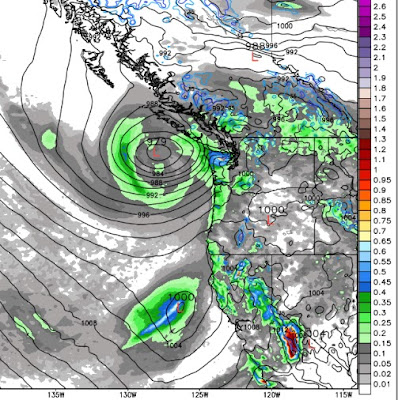
The UW WRF model prediction for three hours later is even more surprising, with the southern low being stronger. I have been watching the weather around here for over a quarter century and don't remember ever seeing anything like this.

The kind of thing that appears in a movie, before the aliens show up. Something that some breathless meteorologists would call "the Perfect Storm." (go to 60 seconds for my favorite weather quote)
This is turning out to be a cool, wet spring and there will be absolutely no water worries this summer in the Northwest. Good for planting lettuce... put mine in last weekend.
________________________
Help Determine Local Impacts of Climate Change
Society needs to know the regional impacts of climate change and a group at the UW is trying to provide this information with state-of-the-art high resolution climate modeling. With Federal funding collapsing, we are experimenting with a community funding approach. If you want more information or are interested in helping, please go here. The full link is: https://uw.useed.net/projects/822/home
_______________
.gif)


It only got to 16 C at my place in Shoreline.
ReplyDeleteWait....
This may be a silly question, but what resource/programs do you use to make the maps of western WA that have high temperatures and/or wind gusts on them? Such as the first image in this post!
ReplyDeleteHere's some activists trying to persuade skeptics on the urgent problem of climate change:
ReplyDeletehttps://www.youtube.com/watch?v=nl53YL9ZES0
I think this movement needs a better MO.
Does this cool, wet spring mean a cool, wet summer too?
ReplyDeleteSo does that mean heavy rainfall? Like an inch an hour. Can someone break this down to a non-weatherperson?
ReplyDeleteOr this cool wet winter and cool wet spring mean a cool wet summer? The trend continues.....?!!! When will it end?
ReplyDeleteCliff,
ReplyDeleteDoes the rain ever end?
Signed,
A desperately cold and wet Texan
Skagit Valley only reached 55F - no tulips (sigh).
ReplyDeletehttps://www.wunderground.com/history/airport/KBVS/2017/4/5/DailyHistory.html?req_city=Mount%20Vernon&req_state=WA&req_statename=&reqdb.zip=98273&reqdb.magic=1&reqdb.wmo=99999