
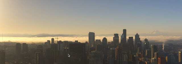
And the view southeastward towards Mount Rainier was impressive as well.
The fog was apparent is the visible satellite image at 7 AM, with some of the river valleys of SW Washington in fog.

It turns out the dense fog is relatively unusual this time of the year in Washington State. I can show this using the following graph from my NW Weather book. Here in Seattle (red color) fog reaches the minimum number of days per year from April through June. Spring is a low time for fog in most locations of our region. Fall is the big fog season.

But why is Spring so bad for fog? For several reasons.
First, most of our fog is radiation fog, which develops over long nights as the earth radiates infrared energy to space. Our nights are getting MUCH shorter now, so much less time for the cooling to occur (remember our day-night periods today are the same as around August 23).
Second, fog likes stable conditions that does not produce a lot of vertical mixing. Such mixing is bad for fog, since the cooling at the surface gets spread over too much air in the vertical. Stable conditions occur when temperatures don't decrease rapidly with height. The opposite is true in Spring...the sun is fairly strong, causing the surface to warm, but the air is still cool aloft. Not stable and bad for fog.

Third, in spring around here we still have a lot of clouds and clouds slow up the radiational cooling from the surface.
Fourth, rain is generally letting up in Spring and rain helps moisten the surface and lower atmosphere...which is good for fog.
Why fog today? We had lots of rain recently so the lower atmosphere was moist. And high pressure moved in late yesterday, which helped make the atmosphere more stable and lessened the amount of clouds aloft.

Can our models forecast fog? They can, but there skill is not great. Fog plays into almost all our modeling weaknesses. Here is the 14 hour forecast for low clouds valid at 7 AM from the UW WRF model. Right idea, but somewhat too much fog/low clouds around Puget Sound.

And now the big news....a major warm up will occur early next week, with highs getting into the upper 60s on Monday and Tuesday. And pretty decent the rest of the week. More on the "big heat" in my next blog.


Could you sometime do a post about summer fog, particularly in the east entrance to the Strait of Juan de Fuca, north into Rosario Strait and uo to Cypress Island? I believe this is advection fog and is quite common during the summer months.
ReplyDelete