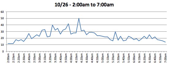
At the Skunk Bay website, the winds even gusted to 50 mph around 4:20 AM.
The cause? A low center that moved into central British Columbia (see pressure analysis at 5AM this morning, below). The low center was not something you would write home about (991 hPa), but there was a strong pressure gradient south of the low that caused winds to accelerate from the south.

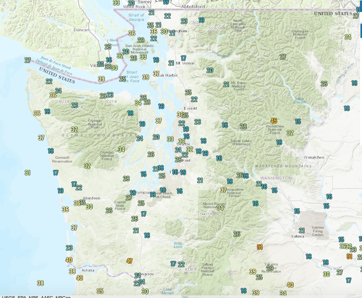
A higher resolution map at 8 AM shows the large pressure gradient more clearly. The lines are isobars, lines of constant pressure, and the pressure gradient is greatest when the lines are closer together. Large pressure gradient or change means strong winds.

The infrared satellite image at 5 AM this morning shows the tight low pressure making landfall on the BC coast (look for tightly curved clouds associated with the low center)

The visible satellite image at 1 PM today was beautiful....and very typical of winter. A well formed cyclone and attendant fronts was east of the west coast and south of the Aleutians. You see the "popcorn-like" clouds swirling into it? That indicates great vertical instability with cold air over much warmer water. A frontal band was sweeping into the Pacific Northwest, and a little "comma cloud", associate with an upper-level trough was due west of Vancouver Is. A great image to use in class.

Tomorrow (Saturday) show be dry in the morning and early/mid afternoon for Puget Sound, but substantial rain will move in during the evening. Heavy rain overnight and more showers on Sunday. As I warned in a previous blog, we have made the winter transition, and you won't see too many dry days in a row for a while.


Awesome, bring it!
ReplyDeleteI've lived in every corner of the US -- New England, Florida, southern CA, Colorado and Michigan before coming here, as well as several locations around the world (Azores, Greenland, Singapore, Malaysia) -- and visited dozens of other regions in all seasons, but nowhere has the weather been as interesting to me as the PNW.
ReplyDeleteOur transition from summer patterns to winter and back are much more fun because the changes are so mild and welcome going both ways. While every place had very enjoyable periods of weather (yes, even Greenland), it is only here, on the OlyPen with the NE Pacific churning away out there, that the weather entertains and pleases me nearly every week of the year.
I love change but I dislike extremes, and no place I've been has so much of one and so little of the other.
This is a good time of year to reflect and give thanks to the weather bounty we enjoy here. I love trees more than any other plant, and green is by far my favorite color given it looks so lovely under both sunny and gray skies, so rain is essential. But it's a rare week when I can't find at least a day or two to hike with my dogs. Perhaps it's the nature of being retired, but I love it when the changeable weather determines what I do each day.
While songs from the 60's talked about moving to where the weather fit your clothing, I think one should live where the weather fits your soul.
Captured it perfectly.
DeleteWinter season? Or Autumn season? We're still 8 + weeks away from the start of winter. It won't be a mild one either.
ReplyDeleteIt show be dry indeed!
ReplyDeleteJohn Marshall: Well put. I also appreciate having Professor Mass provide a knowledgeable commentary of the meteorological highlights.
ReplyDelete