This blog discusses current weather, weather prediction, climate issues, and current events
October 30, 2008
Halloween Forecast and Fall Color
This has been an extraordinary fall for autumn color..the best I have seen in years. Why? According to the resources I checked on the web, fall colors are encouraged when there are warm, sunny days and cool, non-freezing nights. Well this year we have had an unusual number of such days/nights during much of October. In addition, it has been far drier normal. The conditions have been perfect for color and the lowlands are ablaze in reds, oranges, and yellows. The fact we haven't had any windstorms to knock off the leaves certainly helped to.
Regarding the forecast. A band of heavy rain is over western Washington right now...but it should move through by mid-afternoon. So right now it looks fairly dry for the critical Halloween evening period...with only a few light showers at most. So the little goblins and their parents should be dry. A weak front comes through tomorrow morning with some showers. Tomorrow will be fairly warm (high near 60), mostly cloudy, with a few showers. Another stronger disturbance moves in on Sunday...so there will be showers and cloudy on that day. The bottom line...we have switched into the cloudy and wet mode of NW weather...sorry.
The Latest Forecast
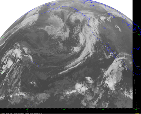
Unfortunately, we have begun the transition out of the fine, sunny weather we have enjoyed during the past two weeks. Take a look at the latest infrared satellite image this morning...a line of moisture is streaming towards the NW and if you look close you can see the swirl of clouds associated with a low center off our coast.
Today there will considerable clouds with few sun breaks...temps reaching to near 60F and a few light rain showers. A heavier band of showers is expected tonight and tomorrow am. The story of the weekend will be clouds and occasional showers...but no major systems. I will give the details tomorrow.
An interesting aspect of weather here is the November transition...October can often be quite nice, but during the first two weeks of November we rapidly transition to the worst weather of the year. The last week of November is our meteorological black hole...the stormiest, wettest, windiest period of the entire year. Barbeque turkey is a NW tradition for a reason....
October 29, 2008
Major Changes Ahead
Well, we have all enjoyed the past two weeks...one of the best end of Octobers in a while. As shown in the graphs (for Sea-Tac AP), our temperatures have been at or above normal and precipitation has been well below normal. And the leaf colors are the finest I can remember. This favorable weather has been associated with persistent high pressure...also known as ridging...over the west coast. But things are a changing. The computer models are all showing a major regime change, with a high-amplitude trough developing just offshore. By Friday, the rains should return and a cloudy, wet weekend is in store. Not raining all the time...but now we will be open to Pacific weather systems.
Today will be quite decent. The front that was approaching us has weakend and will not bring much rain tonight. Very little fog this morning and there will be plenty of sunshine today...mixed with clouds. Temps in the 50s. Dry tommorrow...and then the transition to rain on Friday.
October 28, 2008
Foggy Mornings
This is the fog season in our area. Why? The nights are long and there is lots of time for the earth to cool off as it radiates infrared energy to space. But you need one more thing...clear or nearly clear skies...which still occur now, but happen less often in the middle of the winter. Why? Clouds intercept infrared radiation from the surface and emit some back down to the surface, thus reducing the cooling. So temp drops on clear, autumn nights while the dewpoint, the temp at which dew (or fog) forms, generally remains near constant.
Take a look at the plot of temperature and dewpoint at the top of the UW Atmos Sci building... temp fell through the night, but still hasn't reached the dewpoint. No fog at the UW yet. But look at the other plot..at Sea Tac Airport... The temp dropped and dewpoint rose a bit...and they met....and there is fog there.
On clear nights, the lowest temps are often near or just after sunrise...so fog can form very late sometimes....
Today should be very nice, particularly after the fog burns off...and it still looks like a weak front will make its way across us tomorrow evening...so tomorrow should also be good as well.
October 26, 2008
Wind in the mountains
Yesterday, my wife and I hiked to the top of Tiger Mountain, which reaches about 2500 ft. There was an inversion yesterday morning, with cold air in the lowest few hundred feet and warmer air aloft. Because of a difference in pressure across the Cascades (with high pressure to the east of the crest and lower pressure to the west), there was strong easterly flow (from the east) starting roughly 500-1000 ft above the surface (see weather map with pressure analysis on it).
Winds were weak and temps were cold as we started our hike, but as we gained altitude the temps warmed perceptibly. Nearing the top the winds from the east picked up...gusting to 20-30 mph at least. Check out my video to see what it was like.
Nice weather today..sunny, with highs in the 60s. Same for tomorrow.
Sunday forecast
Today is going to be a perfect fall day....a few high clouds over the region and some fog in a few low-lying valleys. But the fog will burn away soon and temps will claim in the 60s west of the Cascade crest. The long-range forecasts are cloudy/rainy weather next weekend...so today is the day for outdoor recreation or to finish up that painting (which I was doing yesterday!). Monday and Tuesday are also certain to be good.
For those interested, there will be a forum on K-12 math education in our state on the UW campus tomorrow evening at 7:30 PM in Kane 210. I will be speaking there--on math, not weather!
October 25, 2008
Weekend Update
Today is the transitional day...but it really won't be half bad. A weak front is moving through now. It only brought a few light showers to scattered locations. You'll notice that temps are warmer this morning...the reason..the clouds, which prevent the loss of infrared radiation to space. The satellite picture to your right is this morning's infrared picture....white areas are clouds and whiter the color the higher the clouds. Some high clouds offshore and over and downwind of the southern WA Cascades.
Today we will see the clouds progressively thinning and some sun this afternoon...temps reaching the upper 50s. Tomorrow starts the big warm up...lots of sun and temp rising into the mid 60s. And more warm, dry weather in store for Monday and Wednesday.
October 24, 2008
The Weekend Forecast
This morning this was lots of fog and freezing temperatures away from water...so the black ice threat was there. Be careful on these days during the morning.
The forecast for this weekend is still on track. A weak front is now moving in from the north...we have some clouds from it already and they should thicken later...particularly over the northern part of the state. (see the satellite picture) Temps getting into the mid fifties today. The front will move through tonight, with perhaps a few sprinkles. There will be some clouds remaining when you wake up tomorrow...but they should then and weaken during the morning. So Saturday will be decent, with temps getting to near 60. Sunday should be wonderful as high pressure builds over the region and offshore flow develops....should reach into the 60s. Monday and Tuesday should remain sunny, dry, and warm. A front will approach late Wednesday...but right now it looks like the daytime hours should be dry and warm..but with increasing clouds during the afternoon. And then rain on Thursday.
Sat picture caption: You can see the fog in the Columbia River valley north of Portland and in the lowlands stretching up to Puget Sound. Also the Willamette Valley. The front clouds are in the NW portion of the photo.
My black ice web site: http://www.atmos.washington.edu/~cliff/Roadway3.html
October 23, 2008
Latest Weather Analysis
Our temperatures have returned to normal after a period in which we were consistently below normal. Take a look at the plot of the temperatures at Sea Tac airport for the last 4 weeks...the light red line shows the average maximum and the blue line the average minimum. The dark line is the actual temps. We had a few week cool stretch mid month. Yesterday the airport got to 63..well above the normal 57. The end of this month should be better than normal. A week front moved past early this morning and today show be partly cloudy with temps near 60. Friday should be dry with highs again near 60--but with increasing clouds as another weak front approaches. That front will move through early Saturday morning, leaving party cloud skies and highs again near 60F. Then high pressure really moves in and we develop offshore flow...the result...Sunday will be spectacular..highs at least 65 and sun. And the Monday and Tuesday look good too.
October 22, 2008
Spectacular Day and Weekend Ahead
With high pressure over and to the east of us, clear skies extend over most of the area...except some fog in lower elevation near water or in valleys. But sun will reign this afternoon. We got cold last night...even down to freezing...with the clear skies (even some black ice is possible). Temperatures should be above normal today...with much of the low lands getting into the lower to mid sixties. Some favored locations could approach 70. An offshore front is now approaching (see image) and should get here tonight, but will be quite weak, with only a few showers overnight. Another weak front on Friday...but then a major ridge...area of high pressure..will build over the region over the weekend. We should see sunny skies and above normal temps. Plan your outing now.
October 21, 2008
A very different day today. The front is well past us now, rain has stopped, and most of the area is either clear or in fog--especially near water or in low areas (see pic near Lake WA). Dense fog is actually a sign of good weather ahead. Why? It generally forms on clear nights that allows the surface to cool effectively (the surface loses heat due to infrared radiation to space...if it is cloudy, that doesn't work well). Today should be sunny in most of the region, with temps reaching into the 50s. Tomorrow should be even better...as high pressure builds to the east of us, offshore flow will really dry and warm things up. So tomorrow should get into the upper 50's and lower 60s. Perfect fall day. A weak front should cross the region Thursday..but we will be lucky to get a light shower out of it.
October 20, 2008
Monday Weather Analysis
A well-defined line of rain, associated with a Pacific cold front, is now approaching Puget Sound (see the radar picture). In this image the yellow are heavy rain and the green are moderate rain. Note the lack of radar echo on the coast the the triangle shape void over the Olympic peninsula...the reason---no radar coverage! The front should move through during the early to mid afternoon..followed by showers on the Cascades and the formation of a Puget Sound convergence zone north of Seattle...so the rain and clouds might well continue there into the evening. So go to Tacoma if you want dry weather late in the afternoon! Tomorrow and Wednesday should be dry as high pressure moves in. Another front approaches Wed night.
This month has been a bit drier than normal so far....at Sea Tac 1.46 inches of rain, when 1.60 would be normal by now.
October 19, 2008
Foggy morning, but sun will come
With clear skies last night, temperatures dropped into the 30s, and I expect some areas of "black" ice could have formed. With such cooling, fog also forms and fairly dense fog is now over the lowlands (see picture). But it won't last. The area of cold, foggy air is quite shallow and limited (see satellite image) and I expect the fog to be gone by lunch at most locations. Tomorrow morning a fairly strong, wet cold front will be over our area...so be prepared for some rain. The front will move through by the early afternoon, but a Puget Sound convergence zone should form in its wake, leaving rain north of Seattle. It will be sunny north and south of the convergence zone during the mid afternoon.
October 18, 2008
Weekend Weather Update
Looking at the weather observations and models, confirms the predictions on Friday..it is going to be a perfect fall weekend. The weak front that I talked about yesterday is now moving southeast of the region (see photo), leaving behind generally sunny skies, except for a few locations with some fog (which will burn off soon). Temperatures should climb into the upper fifties and lower sixties today. With clear skies tonight, expect the temperatures to fall into the lower forties and thirties tonight...and some local fog could form. But tomorrow should be very nice..dry, with the fog burning off quickly...with temps heading to around 60F. A fairly strong cold front will come in late Sunday night and Monday morning, turning to shower Monday afternoon.
Well, I am off to get some signs ready for this afternoon, I and some others will be at Husky Stadium with signs supporting Randy Dorn, who is running for Superintendent of Public Instruction. All about improving math education in our state.
October 17, 2008
Latest weather analysis
A warm front moved through yesterday afternoon and you can feel it. Temperatures last night remained high and we have moderate southwesterly winds aloft. But change is approaching. A weak cold front is now extending from the northwest corner of the Olympic Peninsula to Vancouver and has some light to moderate rain. The front will slowly move southeastward durng the day, but we should get considerable protection from rainshadow off the Olympics. So increasing clouds and increasing chance of showers late in the afternoon and evening. Nothing major. The front will move through over the night, bring cooler air. The weekend looks great. Some residual clouds Saturday morning...particularly over the mountains...but they should progressively thin during the morning. No rain Saturday and temps getting into the upper 50s. Sunday will be even better...temps getting to 60 and perhaps a few degrees higher. Another front and rain for Monday. Looks like a big ridge and dry spell from Tuesday into Wed.
Take a look at the latest radar image...you can see the rain north of us:
October 16, 2008
A relatively quiet day today...with some clearing NE of the Olympics in the rainshadow of the Olympics. Mostly sunny east of the Cascades. A warm front and some showers moving through tonight, followed by a cold front Friday afternoon and evening. The weekend looks good..dry, with temps reaching the upper fifties.
The image to the right is the 2 PM radar...some showers over Vancouver Island and some upslope showers on the western side of the Cascades.