August 31, 2009

Is San Juan Island the sunniest location in western Washington?


While waiting for the ferry in Friday Harbor, I passed some time at the window of a local real-estate agent, entertained by ads for houses I will never be able to afford (unless someone buys a few hundred thousand of my books!). In some of their literature, there was the claim that the San Juan's were "sun central" for western Washington with more than 240 days of sunshine a year! And looking around on the web, I found that claim repeated on many web sites. Earlier that day I hiked around Lime Kiln Park, on the south shore of the the island and looked southward at the Olympics. It was sunny and warm, the prairie around me sandy and dry. Miles to the south, low clouds had moved through the Strait, and Port Angeles, Sequim, and Pt Townsend were in clouds. I wondered...could the sunniest place in western Washington be where I was standing?


Well, the traditional answer to the sunniest location in western Washington question has been Sequim and adjacent areas--locations downstream of the Olympics during the winter. During our wet season the winds are generally from the southwest, so air moves up the SW flanks of the Olympics (enhancing clouds and precip) and down the NE side (producing drying and less clouds). You can see this effect clearly in satellite imagery (see first image above) and the Camano Island weather radar. The San Juans, and particularly the southern San Juans, get some of this Olympics action, but they are clearly on the northern edge of the downslope drying. I suspect a quantitative analysis would show that Sequim and nearby towns are sunnier during midwinter than anywhere else in western Washington. And this explains Sequim's SunLand Condominium, Sunshine RV Park, and Sunshine Herb and Lavender Farm, among hundreds of other sun-related business names.

But hold on there! The climatological winds are only southwesterly during midwinter and during the spring and summer the incoming winds are often from the west and northwest . And there's more! There is another topographic barrier that has a rainshadow--the mountains of Vancouver Island. And with westerly flow the rain shadow from it is centered right over the western San Juans...and NOT Sequim and its fellow travelers. Take a look at the satellite picture this morning( above)...can you see the lack of clouds over San Juan Island? While Sequim is in clouds. This happens ALL the time in the late spring and summer.

So what is the bottom line here? Sequim is rainshadowed and sun endowed during the winter, but the San Juan's get a lesser piece of this action. During the warm half of the year, San Juan Island gets rainshadowed by Vancouver Island and escapes all the gunk passing through the Strait of Juan de Fuca. Thus San Juan Island could be sunnier than Sequim during the summer.

It may well be that considering the whole year that southern San Juan Island and Lopez could be as sunny or sunnier than Sequim.

This could be calculated more quantitatively using satellite imagery, but at this point I will be content to let the real estate agents battle it out!

August 30, 2009

San Juan Islands Weather


San Juan Island prairie (top) and lavender farm (bottom)

I just got back from giving some lectures in the San Juans and if any place has localized weather features...it is there. The complex combination of terrain and water caused large weather variations, as does the proximity to the Olympic and Vancouver Island rainshadows.
First, there are large variations in annual precipitation. The southern portions of San Juan Island and Lopez get around 20 inches a year due to their proximity to the Olympic rainshadow, while the northern SJuan Island (say northern Orcas) gets around 30 inches, with more on Mt. Constitution and the higher terrain. Lavender likes dry conditions, so there is no surprise that a large lavender farm is found on southern San Juan Island (Pelindaba lavender farm). With dry conditions, wind, and sandy soils, southern SJ Island even has natural prairies (see image above).

Wind variations are huge there. Blockage by the terrain causes "wind shadows" in their lee. Locations (such as Mt. Constitution on the NE side of the islands get hit by the strong wintertime northeasterlies exiting the Fraser River valley. While I was kayaking one morning on the eastern side of the Orcas I was struck by the strong wind accelerations near even modest points and headlands. During the wintertime, strong southeasterlies can buffet the islands (particularly the eastern portions)...winds that are accelerated by troughing (low pressure) to the lee (north) of the Olympics. In fact, when I hiked a bit on the top of Mt. Constitution (2500ft) I could see trees that had fallen in two directions...to the SE (from the Fraser flow) and to the NW (from the strong wintertime southeasterlies).

I found lots of well-educated weather enthusiasts on the San Juans and appreciated the invitation of the San Juan Nature Institute and the San Juan County Dept of Emergency Management . And two very nice book stores--Darvill's Books (Orcas) and Griffin Bay Books (Friday Harbor) graciously attended my lecture with my NW weather books. I left signed copies at both of them.

Editorial comment: Yesterday, I went to Lime Kiln park to view the Orcas...and was not disappointed. Viewed at least a dozen of these magnificent creatures. But I was shocked that both pleasure boaters and some fishing vessels ran just offshore revving their engines and making a terrible racket as they banged repeatedly into the water. Couldn't they stay offshore to allow the poor Orcas a chance? And then a helicopter came in low and circled over them, followed by a twin-engine aircraft that came in for a look. This cacaphony can't be good for the whales, can it? The whale watching boats were out their too....shadowing the orcas...but they seems a bit more discreet than the others.

August 25, 2009

Warm and Dry Ahead


I don't want to hype the heat, but it will be warming up a bit in a few days. But before I talk about that, check out all the action in the Pacific visible satellite image (see image). Two tropical storms over the southern Pacific, a nice midlatitude cyclone in the central north Pacific, low stratus off of California, and thunderstorms over the Colorado Rockies. Something for everyone!

A weak front passed through this morning, but only trace to a few hundreds of an inch of rain fell. As the front moved through skies opened over most of the western side and temperatures rose into the upper 60s and lower 70s today. Tomorrow (Wed) will be a step up in temperature, but Thursday will be the big day as ridging aloft develops and offshore flow strengthens at low levels. So I would expect mid to upper 70s tomorrow and mid-80s over the lowlands (away from water) on Thursday. A weak front will follow on Friday morning...but few if any showers will reach the western interior...although some showers may occur on the coast. The front will bring the temps back into the mid-70s..which is normal for this time of the year.

So nearly perfect weather...you don't need a meteorologist for a while. That is why I am heading to the San Juans to give two public lectures...see info to the right if you are interested.

Several people have asked me what is happening with the coastal weather radar. Well, my colleagues in the National Weather Service and their contractor are hard at work evaluating sites with the aid of some of us at the UW. Work is going well and a report will be made public early this fall with potential sites. But we still need for the remaining money to pass through Congress...and our U.S. Senators are working on this, with the help of our local congressmen. Looks good.

August 22, 2009

Global Warming Misconception II and Two Talks on the San Juan Islands

C02 at Mauna Loa, Hawaii

Global Average Temperature Courtesy of NASA

Well, let me start with the San Juan's first. I have been invited to give two talks there later this week. On Thursday night I will be speaking at the Senior Center, Eastsound, on Orcas at 7 PM and on Friday night at the Grange Hall in Friday Harbor (also 7 PM). These will be "meteorological red meat" talks on the some of the powerful and extreme weather our region endures. The talks will have some common material but will be different. (These talks are sponsored by the San Juan Nature Institute and the San Juan County Dept of Emergency Management).

Now down to global warming. A few comments on this blog and a HUGE number of letters to the letters of local newspapers and online comments have asked the following question:

You say CO2 causes global warming. Well, CO2 has been going up the past ten years and the earth hasn't warmed during that period! Doesn't that mean that the global warming "theory" is wrong? What gives? Some of the more passionate comments go further, talking about liberal conspiracies, Al Gore, hoaxes, and places I don't want to go right now. But reasonable people ask this question...and there is a reasonable (although complex) answer.

Lets start with the data, shown above. Co2 and other greenhouse gases are going up steadily and have been as long as we have had direct measurements. We understand this. Mankind is the culprit. No responsible scientist doubts this. The other figure shows global temperature--generally going up, but there are are some periods of slight cooling or steady temperatures. Since the late 1990s, temperatures, albeit high, have shown little trend. This is what has some people concerned. But its worst that that they say. Some global warming computer simulations show warming during that period (see figure). Now we are really in trouble. Some of the models are failing too! Fox News was right! Mayor Nickels was wrong!
Not so fast. It turns out that global warming IS a real issue and the above doesn't prove anything really. The truth is that we have a signal to noise issue. The signal is the warming due to greenhouse gases. From our computer models and theory, we know that human-induced warming was quite small until recently (last few decades). And our models and theory indicate it will rapidly increase during this century. But there is also what I will call "noise"--natural variability in the atmosphere that obscures the global warming signal.

The atmosphere has all kinds of natural cyclic and non-cyclic phenomena that causes temperatures to vary even without any global warming. You know some of the them...El Nino and La Nina. Or the Pacific Decadal Oscillation. Or the Arctic Oscillation. There are too many to list. And the essential character of the atmosphere can produce variations on time scales of years to decades. Call this noise. And such noise obscures the global warming signal. When global warming is relatively weak (like now) the noise can even stop the warming or even cause temporary cooling. But it won't last. Eventually the noise will change sign (to warming) or the global warming signal will inevitably strengthen as greenhouse gases increases. Global warming will become apparent and more and more significant. There are also some other minor players to note...like solar variability (e.g, the sunspot cycle), which can produce slight reductions in solar radiation for a few years (like the past few).

During the past several years, global warming has undoubtedly lessened due to a combination of natural variability and a slight weakening of solar radiation, but you can bet that this will turn around very soon. (e.g., El Nino's bring warming and we are now switching into one). The fact that warming has paused for a few years really doesn't mean anything and doesn't disprove anything.

Finally, if you have my book there is a chapter on climate change, global warming, and its local implications.

August 19, 2009

Marine air Starting to move in...


Marine air is starting to move along the coast..we should have a very weak marine push tonight...enough to cut the temps by 5-7F degrees tomorrow. The thermal trough is now moving over the mountains and an onshore pressure gradient has developed. Stratus is starting to push across the coast..and you can see this on an image I have never shown on this blog before...the fog product. By combining several infrared wavelengths observed by satellite we can see low clouds at night..take a look at the figure. See the whiter stuff on the coast..that's the low clouds. The latest surface chart below shows southwesterly and westerly flow pushing in around Hoquiam.
Low clouds may make it into the Strait and perhaps to Shelton and Olympia..but it should burn back rapidly in the morning. If today was a tad hot for you, tomorrow will be heaven.

If you want to see an extraordinary picture from the high resolution NASA MODIS satellite...look at this. You can clearly see massive amounts of smoke from the BC fires and the low clouds off the coast.

Finally, my kidding around with KING-5's hypesters should not be taken as a lack of respect for their weather personnel, which are really top rate. And lets face it, other stations partake in weather hype as well....although to be fair, none of them have ace Jim Forman, who is in a class by himself. And their segment on the heat wave tonight was quite reasonable. Sometime, perhaps after a few glasses of wine, I might blog about the TV weathercasters of our area, but the bottom line will be fairly unexciting..we have unusually good tv weather people in this market. But I better stop before I get into any more trouble.

August 18, 2009

Killer Heat Wave or Killer Hype?


IRONY ALERT!!

Updated 2 PM, Wednesday. Guess who showed up at my office just now????...a reporter (Glenn Farley) and cameraman from KING-5 TV!!! They wanted to talk about the hot, dry summer and how unusual it was! When they closed my room's shades, turned on their blinding lights, and closed the door...well, I was a little concerned. I am afraid to see what will go on air tonight. Some sort of revenge tactic? Will they turn me into a scarester too? We'll see.


The media was up to its old tricks last night-- this time hyping the upcoming "dangerous" heat wave. All the TV stations do it, but none are better at it than KING-5. They are masters of the art. First the news anchors broach the topic, with tremulous voices asking the question--will a dangerous heat wave hit the region the next day? Then they turn to a smiling, yet serious, Jeff Renner who provides a knowing, sympathetic, nod of agreement. Last night, he had his work cut out for him, but finds the most extreme temperature maxima in the region to provide some reason for concern (last night he had to really stretch, quoting the temperature in Vancouver, WA.,which gets the Willamette Valley heat). And then they always turn to their on-scene scarester-reporter. And KING has the top weather scarester in the country...Jim Forman. I love this guy. I wish they sold tapes of his segments...I could watch it for hours. In the winter he hypes snow and in the summer heat. During the last heat wave he had a giant round thermometer stuck at 105F that he kept on flailing about. If nothing threatening is going on...no problem..he will describe the terrible events that will certainly happen to the unprepared. And he always shows people desperately buying emergency supplies in convenience stores and supermarkets. I mean...this guy has a winning formula.

Anyway, our models are indicating a substantial warm up tomorrow...and the central and south Sound could see a few 90s....particularly away from the water. The probcast forecast system (www.probcast.com), whose strength includes these types of days is predicting 92F for Sea Tac tomorrow. (Check the graphic for max temps tomorrow).

Easterly flow will develop tonight over the region, bringing further warming to the west side (and the over us is already quite warm). As you can see from the surface weather chart (pressure and temps shown), the famous thermal trough will move into western Washington (chart) with the heat....our temperatures will spike tomorrow and then decline a bit Thursday as some marine air moves in Thursday AM and the thermal trough jumps to the east side.

7 AM update...on wed..looks more like 89-90F at Sea Tac today..warmer, but not that warmer than yesterday

August 17, 2009

Global Warming Misconceptions

There are several questions dealing with global warming that come up frequently...and it happened again this week when I gave a lecture at Google in Kirkland.

"How can you meteorologists possibly predict global warming fifty years from now when you have problems forecasting the weather three days ahead?"

(Some questioners use more earthy language to describe the current state of meteorological prediction skill, while others suggest that weather forecasters use dice for all the skill they have).

Well, we CAN predict what is going to happen fifty years from now and the forecasts are worth listening to. How can that be?

First, let me say that weather forecasts have gotten much more accurate during the past decade or so. And that is due to several reasons: far better computer forecast models (better understanding of physical processes, better resolution due to more powerful computers) and FAR better and much more observations that allow us to start our computer models with a better starting description of the current state of the atmosphere. We rarely get big storm forecasts wrong today and the day 4 forecasts has the skill of the day 2 forecast 25 years ago. Major progress. And these are basically the same computer models used to predict climate.

But forecast skill of even our new models degrades with time and by 1-2 weeks ago there is little forecast skill left. So knowing that, how can we forecast 50 years from now what will be happening with increasing greenhouse gases?


First, a fifty year climate forecast is completely different than a 2 day weather prediction. In a weather prediction we attempt to forecast the exact configuration of the atmosphere at specific times. Exactly what the temp will be at Olympia at noon, the strengths of all the highs and lows and their exact positions at 7PM Thursday, the wind conditions everywhere at exact times. Pretty challenging. And we know based on theoretical studies that our ability to do this degrades rapidly in time. But for climate predictions we don't do this. We forecast averages..like the average temp over 10 years or average precipitation for all the Marches for a decade. This is MUCH easier to do.

Second, the nature of a climate forecast is very different. For weather forecasts our predictions are dependent on the details of the initial state and small errors or differences grow during the forecast. For climate predictions averaged over decades, there is far less sensitivity to the initial state and far more dependence on the overall forcing by the sun's radiation and how the composition of the atmosphere changes its ability to absorb and transfer infrared radiation. For example, if the earth's atmosphere acts to hold in more radiation, than the planet will tend to warm. Technically, one is an initial value problem and other a boundary condition problem. We have run our climate models over the past hundred years and have been able to duplicate the climate variations over decadal time scales...providing confidence in climate forecasts.

The bottom line of all this is that useful climate predictions ARE possible even when weather prediction skill is lost in a few weeks. These climate prediction aren't and won't be perfect. But they provide great insights into what will happen over the next 50-100 years.

My next blog will deal with the other major argument used by those questioning the potential for human-induced global warming..the lack of warming over the past decade. And then I will talk about the hyping of global warming by some scientists and the media.

August 13, 2009

Lightning, the "Crouch", and Joan Baez


I got a call yesterday from one of the organizers of the Joan Baez concert at the Woodland Park Zoo that was held tonight in Seattle. He was worried--the National Weather Service was forecasting showers and thunderstorms during the evening. Thousands of people would be out in the open...with the concert venue in a field surrounding by tall trees and the space filled with metal towers for lighting, sound, and other needs. (Sounds like the scene of some disaster movie!).

How could he keep these people safe? How could they tell whether lightning was approaching? The National Weather Service forecast was for showers and some lightning rolled in late in the afternoon. Their forecast was excellent and the concert started out on the damp side with lots of showers.

Here are some of the things I told him. If you are outdoors in lightning and can't get to safety you need to do two things. First, get away from any tall object--it will attract the lighting. Trees, towers, hills, you name it. It doesn't have to be metal. Just tall. Get at least 100 ft away if you can. Why? Well if lightning hits an object..lets say a tree, the current can reach the ground and spread out along the surface..and can kill up to 50-100 ft away if you are laying on the ground. Or the lightning can jump from a branch directly to you. So keep away from trees. (this was made very real to me while I was an undergrad at Cornell. There was a thunderstorm and a bunch of students gathered under its branches. Lightning hit the tree and most were stunned and several were very seriously, if not permanently, injured).

The second thing to do..the LIGHTNING CROUCH (see above figures). You don't want to lie on the ground..that could be deadly if lightning-induced currents are flowing on the surface. So what you do is to crouch down on your knees with your ankles touching. You can understand why you want to be low...less attractive to lightning, which likes high stuff. By keeping your ankles together, lightning currents riding up one foot will probably pass down the other..thus sparing your vital organs.
It is also recommended that you cover your ears to protect them from the loud sound of thunder. (I know this looks kind of ridiculous, but it works). And if you playing golf--PLEASE--get rid of those clubs and your fancy meta- cleated golf shoes.

I told the concert organizer that if I line of thunderstorms approached it would be best if people retreated to their cars. Cars are very safe...and NOT because they have rubber tires. It is because you are in a cage of metal and the lightning currents will pass around you (I would avoid touching the frame during the storm though).

And keep in mind that lightning can, and often does, strike the same place twice.

When in a thunderstorm you can tell how far the lightning bolt is by counting from the time of seeing the lightning to hearing the clap of thunder...for every 5 seconds you count, the lightning is 1 mile away. 20 second..4 miles distant. You see the lighting flash essentially immediately (since the speed of light is so fast), but sound travels much, much slower.

Well, enough weather safety tips... oil on the road with the first rain in my last blog and now lightning. I don't even want to discuss what happens during the first lightning storm after a dry period...just stay under your covers!

August 11, 2009

The Dangers of the First Day of Rain


The first day of significant rain after a long dry period can be very dangerous on the roads. Why?
During the dry period oil, dust and other debris collect on roadways and the addition of water produces a slippery emulsion. After a few days of rain, it washes off. The other issue is that people are used to dry-road driving and driving habits (like taking that corner slower) are slow to change. There is in fact a literature on this first-day-after-a-long dry spell issue--check out: http://www.drivers.com/article/652/ as one example.

So be really careful driving today...I have already received a number of reports of significant local accidents.

August 09, 2009

What season is this?


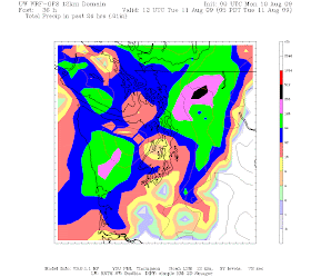
I was struck by the latest infrared satellite picture...a winter-like front is heading for us tomorrow morning (see image)...and look a the predicted 24-h rainfall ending 5 AM on Tuesday (image)! Wow..this is serious rainfall, particularly in the north Cascades. We are going to cooler and wetter than normal for a few days...but guess what...we get warm and dry for next weekend!

Was the heat wave a sign of global warming?


Quite a few have emailed me asking whether last week's heat wave was a sign of global warming. Others have suggested that I have been strangely silent on this issue.

Anything, although I have commented on this subject in my blog and KUOW, let me give you my take on this--and I think the take of most meteorologists.

One heat wave, one storm, one event says nothing about global warming or its effects. That is why those who jumped on Hurricane Katrina as proof of global warming were really off-base.

First, this last hot event was completely localized...while we had record breaking heat, the upper plains and midwest (and parts of the east coast) had record breaking cold. The reason: a persistent ridge of high pressure over the western U.S. and a trough over the central/eastern U.S.-- NOT uniform warming. When I went back east for a meeting, people were complaining about the cold, and those of conservative bent were griping about the global-warming fanatics.

Second, one event does not provide much information on trends, and trends are what count in climate. The atmosphere has a certain amount of natural variability, and there will be records and extremes even if the large-scale situation remains the same. The atmosphere is rarely "normal" and the averages include extremes of both directions.

The media and some climate-action groups are continuously confusing the differences between weather and climate and some of their claims are unsupportable --like the frequently stated prediction that the NW will have more windstorms under global warming. There is NOTHING to support this conjecture. I have even heard some explain the unusual cold/snow wave last December on global warming! (the claim is that global warming will produce more weather variability). And another one is about heavy rain events--that our recent heavy rains/flooding are due to global warming. The truth is that heavy rain events are decreasing in Oregon and increasing over parts of NW Washington (I have a student working on this issue). Why would global warming produce such a dipole effect? (I can speculate on this but won't here).

Don't get me wrong...I am absolutely convinced that global warming is going to happen and will be significant here, but many of the claims about local effects are without support. And because we are downstream of the cool NE Pacific, the Pacific NW may see global warming's effects delayed and weakened.

The bottom line of global warming is that the effects will not be uniform, and that the differences will be profound. And there is much about local effects that we don't know. The whole topic has also gotten too political...with some believing that global warming is some left wing/Gore induced dementia, while others hyping its effects to induce a social/economic transformation or to enhance their political prospects.

I suspect mankind will not act fast enough to reduce fossil fuel use to stop large global warming effects and that we will learn to live with it. But that is another topic...

August 05, 2009

Why Such High Humidities Last Week?

Several of you have asked why the humidities got so high last week. As I mentioned in the last blog, dew point is the preferred measure of how much moisture there is in the air and the dew points last week got into the mid to upper 60s--which are very high for us (the dew points today for example are in the lower 50s).

So lets play detective! One facility meteorologists have is the ability to compute trajectories of the air..the path that the air took over time--thus, we can determine where the air came from that was so sticky and humid.

I have done this...finding the air trajectories for air ending over Puget Sound at 500, 1000, and 1500 m at 5 PM on Tuesday the 28th...the evening before the warmest day and a time with high dew points (see figures). Where did the air come? From the desert southwest as some media types said? No! The humid air came from the north over southern B.C., including the forested slopes of the Cascades.

This makes complete sense if you think about it. Earlier than week, Sat through Tuesday it was quite wet up north...an upper low caused thunderstorms that rotated westward to our north. Don't believe me? Check out the radar image from the Sunday before (see below). So we had very warm air which was passing over moist forests and vegetated surfaces, picking up lots of moisture. But the fun doesn't stop there! The Strait of Georgia is warm! Well, at least a lot warmer than Puget Sound. Water temps there were in the 60s to near 70F...which mean it could provide much more water vapor to the air than the cold Pacific.

So I think we have our answer...warm air passed over moist forests and a warm water surface and picked up lots of water vapor. That made us uncomfortable and kept the temperatures up at night (remember water vapor acts like a blanket).

Now here is the interesting thing. The air really dried out on Wednesday as the temperature surged to record levels. Why? Well, the direction of the air shifted from the moist forests to the north to the dry continental surface to our east. Want proof? Below you will also see trajectories a day later...5 PM on Wednesday, July 29th. And this air was really sinking as it descending over the Sound...producing enhanced warming.


August 03, 2009

The Other Side of the Heat Wave: Humidity

There was another side of the heat wave of the past week--the high humidity. It really felt like the torrid east coast the day before the big record.

Air with lots of water vapor makes us miserable in two ways: first, we can't evaporate water off our skin (sweat) as effectively...and thus feel warmer. Second, water vapor acts as an atmospheric blanket--keeping temperatures up at night.

Many of you have heard of relative humidity--with air have 100% relative humidity when completely saturated. But relative humidity varies with temperature and drops as the day warms. It is NOT an absolute measure of the amount of water vapor and thus meteorologists prefer to use another measure, dew point. (air with 100% RH at 45F has far less water than air with 100% RH at 85F)

Dew point is the temperature that air must be cooled to to become saturated (100% RH). The more water vapor in the air, the less you have to cool it down to get saturated (remember, warm air holds more water vapor than cold air). So dew point is actually a measure of the amount of water vapor in the air.

Still with me? In Seattle, the typical summer dew point is in the lower 50s. In DC it is closer to 70F (a very good reason to avoid living in DC and to appreciate our congressional/senatorial delegation that has to live there).

Take a look at the plot of dew point at Sea Tac for the last two weeks above. The dew point starts in the 50s and rises well into the 60s in the day leading up to the heat wave...that is why it felt so terrible. (some local stations had dew point rising near 70F) Then on the day of the heat, as the dry, easterly flow developed, the dew point dropped . During the past few days the dew point dropped in to the fifties again...and boy does it feel better. Today was spectacular and comfortable...with dew points dropping into the upper 40s in some locations.

And why are our dew points generally low and our summer air much drier than that of the East Coast? The Pacific Ocean. How can that be? Generally our air has traveled thousands of miles of the Pacific...but because the Pacific and the surface air is relatively cold...the air can't pick up much moisture. In contrast, those poor people of the East and Central U.S. have air coming off the Gulf of Mexico...which is well above 80F in the summer. If you want to read more about dew point, there is plenty more about it in my book.

So that's the unsung issue that made last week a terror...unusually high dew points.

PS: There was a question of why it was so humid. The air trajectory was not off the ocean (air would be too dry because the water is cold) and not from eastern WA (too dry because of the surface). Rather, it came from the north--passing over vegetated areas of southern BC....cliff

August 01, 2009

The Warmest July Ever at Sea Tac

The numbers are in, July 2009 was the warmest since record-keeping began at Sea-Tac Airport (late 40s).


The air above remains very warm above us right now...at 850 mb--around 5000 ft-- it is 20C (68F)...which is much above normal. At low levels we have had weak onshore flow, bringing marine air and some clouds in the lower few thousand feet. A vertical profile at Sand Point is shown below. Notice the inversion at low levels, with temperatures increasing with height. The cool low-level air warms during the day and the inversion is slowly burned out in the morning hours...producing rapid warming. Temps remain warm in the mountains where they are above the marine layer.
In the lowlands away from the water temps will rise in the mid to upper 80s..with a few 90s. And very warm hiking weather in the Cascades. This hot period doesn't want to end.

There are some major changes suggested in the latest computer runs for the end of next week, when a strong upper low swings through....convection--thunderstorms--often come with such changes. We will see.