October 30, 2009

Winds

9:30 PM update:  winds are now gusting to 45 mph at Whidbey Is Naval Air Station and 64 mph at Tatoosh Island. 43 mph at Port Townsend. 53 mph at Smith Island.


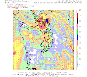
Attached is the latest wind forecast for 8 PM tonight...very strong winds over NW Washington. Pink indicated 40 knots of SUSTAINED WINDS. Gusts could be much higher. If you are on the southern side of the San Juans, northern Whidbey Is, or on the NE Olympic Peninsula coast, be prepared! Don't even think about going on the water.


As shown by the Seattle wind profiler...strong winds (sustained 25 knots +) are above us right now. The air now is in the sixties and the snowpack is rapidly melting.

October 29, 2009

Serious Wind


It will be quite windy tomorrow evening...particularly over NW Washington and along the coast. The latest model run show this clearly (see graphic). Strong southeasterlies after roughly 3-4 PM building into the evening from Everett to the San Juans. Sustained winds of 20-35 mph with gusts to 50-60 mph. Batten down the hatches!

And the rain will pick up in the evening as well as the cold front approaches.

October 28, 2009

Warm, wet and breezy


I am finally ready to talk about the upcoming wet weather--I had to wait until the solutions settled down. This week there were major shifts and changes in the forecasts, not only of the winds but for precipitation as well. The reason for the lack of predictability have been ETs--extratropical transitions. This is when tropical systems move northward into the midlatitude westerlies. As the tropical systems move poleward they transition into midlatitude or extratropical systems and this transition is very sensitive and can induce weather disturbances far afield. Sort of like a freeway entrance....hard to judge exactly what car you will be behind as you accelerate into the traffic.

Well, if you haven't been able to go to Hawaii, Hawaii is coming to you!

A warm front is now approaching our area, bringing clouds and light precipitation (see image above). Most of the rain will be done with by 10 AM and there should be breaks tomorrow afternoon. The 24-h precipitation ending 5 PM shows modest rain over the lowlands, with heavier amounts (1.5-2 inches) southwest of the Olympics and Mt Rainer. Nothing major. But you will notice the change in air temperature tomorrow as much warmer (like 20F warmer) air moves in aloft (see temps at 850 mb--roughly 5ooo ft). Bad news for snow levels. Major melting of today's snow will occur.


But then the second act will occur...the arrival of the premo moist, warm air from north of Hawaii and the cold front. A long thin conduit of moisture from Hawaii to the NW will be apparent on Friday afternoon--and at that time it will be headed for BC (Figure). The infamous PINEAPPLE EXPRESS.

Later on Friday and early Saturday the plume of moisture will sag down over Washington ahead of the cold front. So later on Friday night it will be our turn. Amounts will be substantial over the N. Cascades, perhaps producing minor flooding for rivers there, but not a really serious situation because the front will move through quickly (see graphic showing 24-h rain ending 5 AM Saturday). The worst flooding situations occur when the plume stalls over us. Amazing rainshadow over Sequim and vicinity. By Saturday afternoon it will be through, with postfrontal showers. No major threat for the Green River valley.

October 25, 2009

The Disappearing Windstorm


Yesterday, a few of you were noting the potential for a major windstorm later in the week, with the National Weather Service GFS (Global Forecasting System) model indicating an amazingly deep low pressure system right off our coast. The graphic (sea level pressure-solid lines) is shown above for you amusement (132 h forecast starting 5 AM Saturday). SCARY! Hurricane-force winds offshore! Gales in the Strait of Juan de Fuca! The TV stations would have field day if this was true.

But one thing forecasters learn quickly is to restrain themselves that far out and to look carefully at run to run continuity. Is this forecast stable? Did several model runs (forecasts) show the same feature. Did the forecasts of several modeling systems produce the same solution? For this storm, each run has been very different. Want to see?

Here is the next run starting 12-h later...much less scary--and farther north.


And the run starting 12-h later (this morning at 5 am, 108 hr forecast)... its nearly gone.


Or the run starting a few days (Thursday, 5 AM) before the scary one....the low is weaker and far inland.
The bottom line is that forecasters have little confidence in such erratic predictions that far out. Generally forecasts settle down when one is less than about 108 h out...but not always. The current situation is a particularly tricky one, since some of the energy of a tropical storm in the western Pacific is being injected into the midlatitudes...and that inevitably decreases the reliability of forecasts. The technical terms is extratropical transition...or ET.

October 23, 2009

Nice Convergence Zone


It is pouring outside my home now. Take a look at the radar and surface observations...a very nice convergence zone is apparent in both. But tomorrow should be dry--even with some sun. A frontal system moves in mid-day on Sunday...so have your outdoor fun (or work) tomorrow.

October 22, 2009

Atmospheric River Observatories and the Green River Valley


There is a great deal of interest and concern about flooding in the Green River valley. Before the construction of the Howard Hanson dam in 1962, that valley flooded regularly, which was of minor concern when it was predominantly agricultural. But the dam afforded protection for nearly all heavy rainfall events and allowed the development of the Valley, from Kent and Auburn to Renton. Today, thevalley contains billions of dollars of warehouses, factories, stores, housing, and public infrastructure. The problem, of course, is that the Howard Hanson dam was damaged in the heavy precipitation of last January and the U.S. Army Corps of Engineers are worried about a catastrophic failure if the dam is filled. Currently, they only plan to fill the dam a maximum of 1/3 this winter. From my discussions with the Corps and others, it appears that they can prevent flooding for a 1-2 year return-time storm and perhaps a 5 year storm--anything more and flooding will probably result. Their public estimate has been a roughly 1 in 3 chance of flooding this year. This is also a very personal concern of mine...my son lives in an apartment only a few hundred feet from the river!

The National Weather Service and its parent organization--NOAA--have been revving up to provide enhanced prediction of atmospheric and hydrological conditions. The NWS will be placing 11 additional rain gauges in the Green River watershed. This is very useful--we need a better idea of how much rain has fallen, so we can run accurate hydrological simulations of river level and to evaluate and calibrate our atmospheric models.

But something else is going in and is the subject of considerable hype and misinformation--a NOAA ESRL (Earth System Research Lab) Atmospheric River Observatory (see the picture above to see what the instruments look like). This lab has already made the front page of the Seattle Times and has been described in various local newspapers. Emergency managers and others have asked for more of them, at considerable public cost. But as I will describe below, they really won't help much and are not worth the expense.

Most of our local flooding events are associated with narrow plumes of warm, moist air coming out of the subtropics--known as atmospheric rivers or pineapple expresses in the literature. A view of the moisture stream associated with the Dec 07 event is shown below. Our computer forecast models are getting very good at predicting these events and the forecasts of most of the major events of the past several years have been quite accurate--but not perfect.

In order to provide more information about the flow coming off the Pacific, NOAA ESRL has recently installed one of their Atmospheric River Observatory equipment suites at Westport along the Washington coast. This system can measure the weather elements at the surface, as well as the winds, precipitation, temperature, and humidity IMMEDIATELY above the unit. This week the unit went operational and you can get to the information at this web site: http://www.esrl.noaa.gov/psd/data/obs/

A sample of today's output showing the height of the freezing level (black dots) is shown below. Now it is certainly nice to have this data for verifying our computer models, but it really is not very useful for forecasting. We already have a very good idea of the freezing level from the Seattle profiler, aircraft ascents and descents into Seattle Tacoma Airport, and the local radiosonde (balloon-launched weather obs) that we have now. Besides when we have a flood-inducing atmospheric river event the air is inevitably so warm that we know that the whole Green River Watershed is in rain. In addition, the air is moving so fast during atmospheric river events that coastal air reaches the Cascades in about an hour or two. Finally, the data is only from a narrow pencil beam above Westport--which does not give us the comprehensive view we really need. Image a cat scan that only shows the details beneath a single point--few doctors would use it.

In contrast, the coastal radar we are getting in a few years due to the efforts of Senator Cantwell and others in our state delegation will provide a wide ranging view over the entire region...including well offshore...that will be of great forecasting utility.
There are some well-meaning individuals (like the emergency manager mentioned in the Seattle Times article) who want the NWS to secure one or two more AR observatories--at substantial public expense--to provide more "protection" and warning--and they propose to put them at or near the dam. But let me be honest--these will not help weather or hydrological prediction very much. They might be nice to have for research purposes, but won't assist the threatened folks of the Green River Valley.

Rather than spend large amounts of money on such equipment, it would be far better to expedite the coastal radar so its substantial capabilities are on line a year earlier. This year is an El Nino year which reduces the threat after the new year...next year could be a neutral year--when the worst flooding events tend to occur.

October 20, 2009

Undermining Math Education in our State

As many of you know, improving math education is of particular interest to me--particularly since I see on a daily basis the poor math skills of many entering UW students. And I was stunned by the questionable materials provided to my own children. I am active in a group called wheresthemath.com, which includes thousands of parents and educators from throughout the state trying to do something about it.

Two years ago the State legislature got tired of the terrible math standards (or requirements) in our State and took authority away from Terry Bergeson, then Superintendent of Public Instruction. Ms. Bergeson was an advocate of discovery math (a.k.a. fuzzy or reform math), which is weak on fundamentals, but heavy on calculator use, group learning, and writing about math. Under her watch, discovery math came to dominate our K-12 schools, and student math skills declined.

Today somewhat improved math standards are in place (better, but far below what they should be) and the new Superintendent of Public Instruction Randy Dorn has instructed his staff to drop the math WASL and to develop new End of Course assessments. But the problem is that he did not replace Bergeson's old staff and they are committed to keeping the poor Discovery math in place. One of his senior math education staff testified FOR the poorly reviewed Discovering Algebra and Geometry series when considered by the Seattle Board of Education. With her encouragement, the Board voted to acquire these extraordinarily bad high school math books (rated "mathematically unsound" by mathematicians hired by the State Board of Education). But that is not the worst of it, OSPI staff are now editing the new state standards so that only portions they like will be tested.

Recently, Dorn's staff released the Test Development Guidelines that will guide the writing of new WA standardized tests. These are on the OSPI website in the What's New box at this link: http://www.k12.wa.us/assessment/WASL/Mathematics/default.aspx. In these guidelines, bold text is used to indicate what parts of each state math standard should be tested.

Even a cursory examination of these guidelines reveals that state standards are being compromised to further a Discovery math agenda. Fluency, competency, and standard algorithms are not deemed important enough for evaluation. To illustrate this problem, consider the following key grade 3 standard, with the bold text representing content to be assessed:

"3.1.C Fluently and accurately add and subtract whole numbers using the standard regrouping algorithms." (page12)

As you can see, neither fluency nor standard algorithms will be tested. The same undermining was applied to multiplication and division, with none of this standard bolded:
“4.1.A Quickly recall multiplication facts through 10 X 10 and the related division facts. “ (page26)

So none of our state students have to worry about knowing multiplication and division facts very well! So students won't have to know that 4x5=20, or 36/6=6!
According to discovery math supporters, that's for calculators to know, not kids.

And the same treatment is given to fractions and other key mathematical skills.

You can look through the rest yourself, but the bottom line is that the State math standards are being gutted by these folks. Fluency in basic operations will not be tested and they are trying to push the reform approach of heavy reliance on calculators and inefficient discovery-math algorithms (a good video on fuzzy math was made by fellow meteorologist M.J. McDermott, who is also a member of wheresthemath.com: http://www.youtube.com/watch?v=Tr1qee-bTZI).

Randy Dorn campaigned with a promise to clean up the math mess in our state, so each child could get a world class math education. It is time he replaced the Bergeson dead-enders who are undermining his intentions and maintaining the failed policies of the past. Editing standards is clearly subverting the expressed written intent of the Washington State legislature and the needs of our state.

October 17, 2009

Amazing Rain Intensity


An hour ago, an amazingly intense line of thunderstorms passed through central Puget Sound. At my house there was nearly .4 inches over 15 minutes--and my gutters did not do very well with that volume of water. Take a look at the radar--you can see areas of red...those are intense rainfall areas...and one went over my house--and there wasn't any hail, which is usually associated with such high values. Just amazingly intense rain with big drops. An image from the new Rainwatch system (which will become public soon) is show below as well...many lowland locations have gotten 1.5-2 inches over the last day. Some areas received over two. Scattered urban flooding has occurred. No issue with the Green River--early in the season and its watershed did not get sufficiently large amounts of precipitation for any concerns.

October 16, 2009

A very wet Saturday (and the Green River will not flood)


The latest high resolution forecast model runs are in. As are the new ensemble predictions (running many lower-resolution versions to determine the uncertainty of the forecasts). The bottom line...it will be quite wet during the next 24-36h...including the central Puget Sound region, the Olympics, and the Cascades.

Lets start with the latest satellite picture (attached)--you can see the plume of moisture that is approaching us. You can also see a wave in the clouds--that is a developing weather disturbance that will move through tomorrow and enhance the rain.

I will show you a graphic now I have never shown before...from the new RAINWATCH system my group is developing for Seattle Public Utilities (who are very concerned and proactive about heavy precipitation and flooding in the City). This shows you the rainfall over the past twelve hours based on combining the local radar and surface rain gauges. You can see the rain shadow NE of the Olympics and the heavier rain over Seattle and the central Cascades (keep in mind the blockage of the radar SE of the Olympics and over portions of the Cascades). Many locations have gotten over .5 inches in the later regions, some with well over an inch. But there will be a lot more.
Next the latest information from the high resolution forecasts. The precipitation may back off a bit tonight and then hit hard tomorrow as the disturbances comes in. The 24h totals ending tomorrow at 5 PM (Saturday) show a drenching...with 1.26-.2.5 inches (pink) over many locations (like central Puget Sound), with some places getting 2.5-5 inches. The subsequent 24 hours (ending 5 PM Sunday) brings precipitation, but far less (graphic). A frontal passage late on Saturday will transition us to a drier regime on Sunday with scattered showers. So that is the day to get out (and dry out). Maybe a hike in the Olympics.

So lets talk about the Green River...there should NOT be flooding from this. The river is very low now and this event is not the equal of the big ones. There is plenty of room behind the dam to store water right now.

Around the urban core there could be some localized street flooding...particularly if leaves clog the drains...so it is a very good idea to clean the drains in front of where you live or work.

October 15, 2009

Heavy Precipitation


Just a brief heads up about fairly heavy precipitation that will hit on Friday and Saturday. Take a look at the latest high-resolution (4 km WRF) 24h precipitation ending Friday and Saturday at 5 PM. A plume of moisture associated with a Pacific front will slowly move southward over the region. Black indicates 2-5 inches over 24h. Both the SW Olympics and the central Cascades get hit fairly hard. This is NOT equal to one of the major pineapple express events, but the first major mountain rains of the season.

The Green River watershed will get significant rainfall from this event. Nice rainshadow NE of the Olympics. The front moves through later on Saturday and Sunday bringing showers and a strong convergence zone north of Seattle. More later--have to teach 101 now.

I am canceling my hike on Saturday! Time to head to Sequim.

October 13, 2009

Bicycles Safety/Weather/Big Storm

We are now entering the dark, rainy time of the year, when visibility declines and roads get wet and slippery. A much more dangerous time for those in our community who ride bikes to work or cycle for pleasure. I cycle to work each day and have been in more than a few accidents myself--including one incident when a driver deliberately ran over my bike.

Many local communities don't take bicycle safety seriously and Seattle is a poster child for a lackadaisical attitude towards providing safe bikeways. The city acts like they are doing a lot for bicycles (and they have printed costly, multi-color bicycle maps to prove it), but its all a hollow promise. Want some prime examples?

(1) There is no dedicated bicycle path--without contention with cars--into or out of the city. The Mayor talks big about encouraging bike commuting...but the lack of safe, car-free, bike paths for commuting to the city in unconscionable.
(2) Until recently the heavily used Burke Gilman trail was full of deep ruts and bumps from tree roots and other reasons. Very dangerous. I saw one individual thrown by one of those ruts and taken away by an aid car.
(3) The City has plastered white bicycle symbols all over major arterials--somehow suggesting they are safe for cyclists (I think they are called sharrows--see pic). This is recipe

Sharrow on the Fremont bridge..both cars and bikes share this right lane where cars have to be to turn. I have seen some very close calls here.

for disaster as bikes are encouraged to ride in very dangerous territory. But it allows them to put lots of bicycle route lines on their maps.
(4) The Fremont bridge is a very dangerous place where cyclists and cars are thrown together in the same lanes.

The laws are quite weak regarding penalties for motor vehicle operators when they hit or kill bicyclists. (and dozens die each year) Tomorrow there will be a justice seminar at City Hall in Seattle to talk about this issue and all are invited to attend--check out the web site: http://www.cascade.org/Advocacy/traffic-justice-summit.cfm

OK, enough editorializing. Now back to weather. Want to bike and stay dry? No, you don't have to move to Phoenix. Use the weather radar.

On my department web site (and many other places, like the NWS sites) you can view weather radar animations. Rain is rarely uniform. Looking at the radar you can time your cycle, avoiding the heavy stuff most of the time. Ever since I began using the weather radar, I rarely have gotten very wet--even during the winter. Really--using the radar can change your life.
Not the time to go for a ride.

Finally, we have some big weather to talk about. Today, heavy rain struck the Bay Area-- a few gauges today outside the San Francisco metro region at elevated locations received more than 10 inches, including 12.08 at Mt. Umunhum and 16.81 inches at Mining Ridge. Even the lowlands near SF got 2-5 inches. That is big rain down there.

But our turn is coming on Friday. I will post more about this tomorrow...but take a look at the high-resolution model precipitation prediction for the 24-h ending Saturday at 5 AM (see graphic). WOW! Over 5 inches (red color) in portions of the Olympics and several inches over a substantial area. And the rain is not over yet. The first big rainfall of the season. We really could have used the coastal weather radar for this one--with the potential for a rapid rise on SE Olympics rivers and streams. At this point it does not look like a problem for the folks downstream of the Howard Hanson Dam. You will not have to water your garden anymore.

October 11, 2009

A shift to stormy conditions


Well, it couldn't last forever. Several you have asked about a big storm in the offering. Well, there will be a big storm...but sufficiently offshore that the major winds will only strike the coast and offshore. Tomorrow--Columbus Day--will be benign, with some mixed clouds, no rain, and temps reaching the mid-50s.

But on Tuesday a major low will move up along the coast (see graphic), with strong winds offshore (graphic). Not much for us wind-wise. Rain will also be modest over Washington, but for California, it will be a different story, with heavy precipitation on the coastal mountains and the northern Sierra (see graphics).
On a another topic...I took a bike trip up the Green River in Kent today--not many sandbags or other preparations and the waterway looks in good shape there. I did see one amusing sign for "Sandbags to Go." Sounds like a perverse form of restaurant delivery service.

October 10, 2009

Tomatoes Beware! and the Importance of 2 meters


There was more clouds last night then originally predicted and they should hold in much of the area today. With the clouds intercepting and radiating infrared radiation back to the surface, temperatures held up overnight in the 40s over much of the area.

Tonight (Sunday AM) should be different with clearing skies and unusually cool temperatures aloft there will be good radiational cooling. Working against that will be the significant offshore pressure difference, which can keep some wind going in exposed areas. Wind causes mixing which helps stir up cool air near the surface. But sheltered valleys away from water could drop into the 20s tonight...and tomatoes don't like it. Below are two maps showing the low temps tomorrow morning. The first from probcast (www.probcast.com), the UW probabilistic prediction system and the other a straight forecast from our high-resolution WRF numerical forecast model. Cool away from the water, over the SW Washington interior and eastern WA.

Another pulse of cool air hit E. WA tomorrow..and that is when they will get some dust if they get any. This is really a marginal dust event.

Finally, keep in mind that surface air measurements shown on the web and TV are NOT at the surface, but at 2 meters (roughly 6 ft). On cold, calm nights it can be much cooler at the surface than 2 meters...perhaps 2-5F cooler. So keep that in mind while driving. And your car thermometer has the same issue (although it is measuring more like .5-1 meter above the surface).

October 08, 2009

Dust Storm Redux?


A dry weekend is ahead, but there is some interesting meteorological action in our future. A fairly strong cold front followed by rapidly increasing pressure will push into eastern Washington tomorrow...with several pulses of cold air and high pressure over the weekend. Take a look at several forecast charts over the next few days--they show sea level pressure, surface winds, and temperature (with blue being cold). Notice how the cold colors push in as the cold front moves southward.

This surge of cold air will cause fairly strong winds from the north and northeast...but not as strong as last Sunday. Winds will surely reach 20-30 mph, with some stronger gusts--and such winds are strong enough to raise dust.

The problem is that many farmer's have tilled the soil in preparation for next season, and the ground is very dry. As noted above, it takes a 20-30 mph winds to raise significant dust and we will probably attain this--with the strongest winds probably on Sunday. The Spokane NWS office has already put out a warning for poor visibilities in blowing dust. So be careful if you are driving east of the Cascades this weekend.

If you look carefully at the forecast pressure maps above you will note that there is a tongue of particularly high pressure over the eastern slopes of the Cascades. This is caused by cold-air damming whereby cold air is pushed up over the eastern slopes. Strong easterly winds should also pour out of the Fraser Valley..so Bellingham and NW Washington will also get strong winds. But no dust.

October 05, 2009

Major Duststorm and Strong Winds Hit Eastern Washington. Damaging Winds Over NW Washington

Extraordinary winds struck eastern Washington on Sunday, with 30-40 mph winds being commonplace, with gusts reaching nearly 60 mph around Wenatchee and vicinity. The result a major duststorm that closed down I90 for a while and resulted in numerous multicar accidents, sending 11 people to the hospital. Visibilities had dropped to less than five feet at times and the powerful winds knocked down many of the apples still on the trees near Wenatchee. It was reported that the ground at some orchards had turned red with apples.

An amazing picture is shown above from one of the the NASA MODIS satellites, clearly showing the dust (the brown stuff oriented NW-SW). The strong winds came at a bad time.... farmers had plowed up their wheat fields in preparation for the next season and rainfall has been very low this year. Although this is one of the worst dust storms in a while, it happens relatively frequently--my book has a section on it.

So why the strong winds? We had a combination of cold high pressure in Alberta and southern BC and a strong low over eastern Oregon and vicinity. The result was the creation of very strong northeasterly winds aloft and an intense low-level pressure gradient (see graphic). You see how packed the lines (isobars) are...that is a HUGE pressure gradient.
The computer model forecasts were quite good with this event and the National Weather Service had timely forecasts out well before. Want to see a vivid video of how bad it was...check out http://www.youtube.com/watch?v=yr819WqZMak

But the fun doesn't stop there. Western Washington got part of the action too (but no dust storm alas). As the high pressure built into southern BC a large pressure difference was established down the Fraser River Gap, allowing air to accelerate to the SE in that near sea level gap. Bellingham got hit hard, with winds gusting over 40 mph--accompanied by downed trees and power outages. Again, the computer models had it...see the graphic of wind speed predicted for 8 am on Sunday. You can see the strong NE winds exiting the gap. One of the great things about this blog are the reports I get from many of you--and this event was no exception.

Abram R. ("Abe") Jacobson, Earth and Space Sciences/ University of Washington, was sailing east of Bellingham yesterday and reported seeing waterpouts to the lee (west) of Lummi Island produced by the intense shear produced by the interaction of the strong winds with the island. To quote a warning in his informative email:

"If there are waterspouts on the lee side of Lummi, be afraid. Be very afraid! Water spouts are severe weather."

October 03, 2009

The Meteorological F Word and Improving Weather


Temperatures over the region have been generally a bit cooler than normal during the past week (see graphic) as a cold, occasionally showery, upper trough has influenced our weather. But things are going to change in a big way--towards extraordinarily fine autumn weather.

The upper level weather map for later today shows the upper trough starting to move south of us, and as a result most of the showers are found over Oregon and southeastern Washington. The visible satellite image this morning shows those shower areas and some low clouds and fog over parts of western and eastern Washington (image). But don't worry about that. The computer forecast models are in agreement that the trough will progressively move south and a HUGE ridge (high pressure) will develop over the eastern Pacific. I have included below the upper level charts for late Sunday and Monday--not only is there a ridge...but northeasterly and easterly flow develops over...and such offshore flow produces rapid drying and west side warming.

But now the F word for all gardeners...especially those of us with the hopes of gathering the last of the season vine-ripened tomatoes. Frost. Nights are getting much longer now and when the skies clear there can be strong and extended radiational cooling to space. Yes, you and everything else emits infrared radiation and thus the ground can cool overnight this time of the year. Clear skies and low humidity promotes this.
Take a look at this morning's temps at 7 AM. Temperatures at some locations both east and west of the Cascades dropped into the 30s. Remember these are air temperatures at 2 meters...around 6 ft. It can be cooler at the surface! And as skies clear the next few days and the atmosphere dries, the radiational cooling will increase...so there is certainly a substantial risk of frost in the coolest places (away from water, low spot where cold air drains, etc). So if you have some cold sensitive plants on both sides of the Cascades...protect them.