March 30, 2014

The Wettest March in Seattle History and Stillaguamish Precipitation

The rain is mainly over now for the remainder of the month here in western WA, so I can analyze the precipitation totals with some confidence.

Seattle has had the wettest March in its historical record.

As of 5 PM last night, there was 9.44 inches in the gauge at Seattle-Tacoma Airport, more than TWICE the normal March monthly total of 3.72 inches.   This is the all time monthly record for March at this location, for a record going back into the late 19th century (at the airport until 1948 and downtown Seattle before that)

At the National Weather Service office in north Seattle (Sand Point) they also had their monthly record for March (9.22 inches), for a shorter observing period (going back to 1986).


My lawn has turned into a carpet of moss and my deck is now green. 

The plot of precipitation versus normal (yellow line) for 2014 shows the story (upper plot below).  Seattle was quite dry from mid-January to mid-February, but then the pluvial gods took over for the next month.


Many of the stations around Puget Sound are having a top-ten precipitation total for March, but the amounts appears less unusual than Seattle at places like Olympia and Bellingham.

Many of the heavier precipitation events over the region were associated with atmospheric rivers, plumes of moisture appearing to project northeastward out of the subtropics.  The image below shows vertical moisture totals and was provided by Sheldon Kusselson of NOAA/NESDIS.  You see the fingers of high moisture values (generally green) heading right towards us?  When that moisture interacts with our mountains, heavy precipitation results.


Naturally, there is substantial interest in the precipitation that fell on the mountains around the landslide area near Oso, Washington.   As I mentioned in a previous blog, perhaps the most relevant location is the Finney Creek RAWS site (see map, oval shows the landslide, symbols the observing location) in the terran about 7 miles to the NNE of the landsldie


Here is the precipitation at Finney Creek since the beginning of the year.  After a dry stretch it started to rain again around Feb 12th, with a big ramp up the first two weeks of March.


Here is the hourly rainfall and cumulative total in March.  About 22 inches this month, and some periods of intense rainfall (hourly totals exceeding .3 inches an hour). 


There is not a long record at this site, but 2007 was almost as wet (20.04 inches),

Deep-seated landslides, such as the Oso slide on March 22rd, respond more to longer-period rainfall rather than heavy rainfall over hours or a day that result in many shallow slope failures.  Why the slope near Oso failed during this particular period is something that will undoubtedly be studied by geomorphologists more knowledgeable than I am in such matters, such as UW's Professor David Montgomery.

March 28, 2014

The Landslide State

If you were trying to design a region that would have a large number of catastrophic landslides, what would you include?

  • You would start with an area with substantial terrain and steep slopes.
  • You would make sure the area had loose and unconsolidated soils.
  • You would make sure there was plenty of rain and that much of that rain would fall in a relatively short period..
  • You would have a group that would cut down large water-intercepting vegetation and disturb the soil to promote slope failures.  And this this group would leave lots of debris around that would dam up rivers and streams, releasing quickly to promote torrents of downward-moving material.
  • You would add large numbers of people and buildings on top of or at the bottom of sloping terrain.
  • To top it off you might add earthquakes that could contribute to the initiation of slides.
Well you don't have to imagine this landslide-optimized region.   Many of us live in it.  Washington State.   I think one can make a strong case, based on landslides of the past century, that Washington State experiences more catastrophic landslides than any state in the U.S..  To illustrate the problem, here is a map showing some of the landslides during One storm: the atmospheric river of  January 2009
Or if you look at the Washington State Department of Natural Resoure's hazard directory, many landslides have been identified over northwest Washington;

So let's go through the checklist why the Washington State environment fosters large, damaging slides and debris flows.

First, there is terrain.   We have lots if it, withmany  relatively steep slopes (see map).


Then we have the impacts of glacial sediments. Washington is far enough north to have experienced glaciation during the past ice ages, with the one that ended about 10,000 years ago pushing over the north Cascades and Puget Sound (see map)


As the glaciers retreated they left sand, silt, and loose material (see image) and all of these materials are porous and weak.  Melting glaciers can produce lakes in which finer clay particles settle out, leaving a near waterproof barrier. If one of these clay layers are underneath the loose sediments, that can result in the sediments not draining and becoming saturated.   Water within the pores of sediments act as ball-bearings allowing soil movement and failure.  


And glaciers do something else that contribute to landslides:  as the glaciers melt, enormous weight is taken off the terrain, which subsequently rises over thousands of year.  Rising terrain contributes to increases slopes, particularly when river are cutting through them.  Retreating glaciers have also left fairly steep cliffs and bluffs, particularly along margins of Puget Sound, that are prone to failure.

As a result of the movement of glaciers southward during past ice ages and their subsequent retreat, northern Washington has been left with weak sediments, underlying clay layers, rising terrain, and bluffs--all contributors to slope failures.

And then there is heavy precipitation, which can saturate the soils.  As the pores fill with water the soils become heavier (pulling them down the hill) and the lubricating effects of the water promotes weakening of the soil structures.   

The western side of the Northwest has some of the heaviest precipitation the country, with some slopes receiving 60-120 inches a year (see map)

But is is worse than that.  Most of the precipitation falls in a third of the year (roughly November through February), ensuring the soils become highly saturated during the winter.


But it is even worse than that.  The Pacific Northwest often experiences atmospheric rivers (also known as pineapple expresses), with moisture streaming out of the subtropics that can bring intense rainfall (10-20 inches) to the mountains over a day or two.  (see graphic).   Many landslide events have been initiated by torrential downpours of strong atmospheric rivers.  Washington and Oregon get more atmospheric rivers than any place in North America.   And, by the way, the latest research suggests that such rivers will intensify under global warming.
Finally, all the rain around here produces vigorous rivers, like the Stillaguamish, that eat away at glacial sediments, steepening the slopes and contributing to slope failures over time.

And then there is the timber industry.   Many landslides have been the byproducts of the activities of some of the less responsible members of this group.   Trees intercept water from reaching the soil and draw moisture from the soil with their roots.  Thus, clear cutting results in much more water reaching and staying in the ground.  Furthermore, tree roots can also help to bind the soil together.  And then their are the roads built on steep slopes by the forest industry.  Improperly designed such roads can be the source of initiating of slope failures (see image).


Poor forest practices can lead to debris falling into rivers and streams causing damming.  And when such dams finally release during heavy rain events, one can get highly damaging debris flows.   One example of such a flow occurred in 1983 after heavy rains above Lake Whatcom (near Bellingham).  The result was severe damage at the base of several streams descending into the Lake (see image)

And then there are the region's earthquakes. Earthquakes can trigger landslides in a number of ways.  The shaking can accelerate materials downward, initiating a slide. The shaking can cause failure of soil structures that were maintaining soil integrity on the slopes.  Or earthquakes can cause liquefaction, in which the acceleration by the earthquake can increase the pressure of water in the pores, resulting in the loss of adhesion of the soil particles so they act more like a liquid than a solid.

And finally there is the tendency for too many Washington State resident to live in landslide-prone locations. Huge numbers of people have built homes on the bluffs above Puget Sound or on the Sound below.  Many houses have been destroyed and some lives lost as a result (see picture from a tragic case on Bainbridge Island)

Others live on rivers, which often are adjacent to steep slopes produced by the river itself.  The Oso landslide is an example of this, but there are many others.

For all of the above reasons, and some I have not discussed, Washington State has large numbers of landslides, with many of them being quite severe and damaging.  The recent landslide near Oso is one of the greatest environmental disasters in Washington State history and hopefully it will initiate a conversation about where people live in our state and being more able to respond to environmental disasters.

March 26, 2014

Google Could Greatly Improve Weather Forecasts: Will It Take the Necessary Steps?

Google could make a huge contribution to weather prediction, undoubtedly saving many lives and billions of dollars of economic costs due to severe weather in the U.S. alone.  It is something that is well within their technical capability and would cost little.  And if Google can't help, Facebook or Twitter would be almost as good.

What am I talking about?   Collecting millions of pressure observations each hour from smartphones. 

The skill of weather forecasts, and particularly predictions of smaller-scale features, such as severe thunderstorms or strong fronts, depends on having detailed observations of the atmosphere.   And even today, meteorologists often don't have enough.  As we secure more computer power and run our models at finer and finer resolution, we need the data to describe small-scale structures that can lead to tornadic thunderstorms, flash floods, downslope windstorms, and other serious threats to life and limb.


Surface pressure is a uniquely valuable observation.   It is the only surface parameter that reveals information about the whole depth of the atmosphere (since pressure is dependent of the weight of the atmosphere above).  Recently, atmospheric scientists demonstrated they could determine the entire structure of the atmosphere with pressure observations alone.  Pressure observations can be taken inside or outside of a building, in your pocket or purse, in the the sun or out.   It is a forgiving observation to make.

And initial research, like that done by my graduate student Luke Madaus, has revealed that additional pressure observations can substantially improve forecasts of small scale storms and weather features. For example, using only a handful of smartphone pressure observations substantially improved the forecasts of thunderstorms over the eastern slopes of the Cascades (see figure).
The radar echoes on the eastern side of the Cascades (thin solid lines) compared to the predictions of max thunderstorm radar returns from a collection of forecasts (colored dots).  Left side, without smartphone pressures, right side, with smartphone pressures.   The right side is much better!

Forecasting the initiation of major thunderstorms in the Midwest and Great Plains depends on knowing the details of wind, temperature, and pressure.  A dense network of smartphone pressure might greatly enhance such forecasts.

In several past blogs (here and here), I told you about the excellent pressure sensors that are in a number of Android smartphones (e.g., Samsung Galaxy S3, 4, 5;Samsung Nexus) and a few others (e.g., Nokia 1020).   Today, there are probably 10-20 million Android phones in North America alone that are taking pressure measurements-- measurements folks in my professions need.

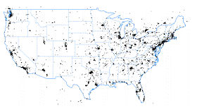
During the past two years I have been talking to two energetic, young start-up firms that are collecting pressure observations from smartphones through two free apps (Pressurenet and OpenSignal).   The principals of these firms have shared the pressure data with me to evaluate the potential of the phone pressure sensors.   Combining both groups' collections, which I get in real time, results in about 25,000 pressure observations per hour across North America (see graphic, each dot is one pressure observation)

In some metropolitan areas there are so many observations that the figure turns black, but there are plenty of areas of poor coverage, including regions (like the Great Plains) with terrible storms.  In reality, the current collection is only securing data from one thousandth of the smartphones out there.  Imagine, what a million observations per hour would look like.  I suspect the eastern half of the U.S. would turn black and coverage over the west would get far better.  Remember, farmers and ranchers have smartphones and so do folks traveling the interstates and other roads.

But now we get to the problem and why Google is essential.   Only a very limited number of people have loaded the free pressure apps and we probably will never get the density we need following this route.   We need to put the code for collecting the pressure observations and the position of the smartphone in software that millions of folks have.  And because most of the smartphones with pressure are Android base, the software has to work on Android phones first and foremost.

What one company has the ability to do this?  You know who:  Google. 

Imagine if GoogleMaps, which is surely used by millions, collected pressure information.  That app is already transmitting position to Google to allow determination of car speeds.  Pressure would be a relatively trivial addition.

Or even better, what if the Android operating system itself collected the pressures (after giving the user a chance to op out, of course.)  

Google could do this and have a tremendously positive impact on society, hopefully sharing the data with the National Weather Service, the research community, and the U.S. weather industry.

I have talked to my friends in Google and several have tried to talk to contacts at Google's Mountain View headquarters.  I have emailed the head of GoogleMaps.  Nothing has happened.  No response at all.

Perhaps one of you is well connected with someone high enough in Google management to get someone's attention.  If so, maybe you can help.  Or maybe someone in Google management reads this blog.  Google is working on lots of technological advances, like autonomous cars.    Why not improving weather prediction? If invited, I am ready to fly down to the Bay Area to talk or give a presentation on this issue.

If Google won't do this, the next obvious possibilities would be Facebook or Twitter, both with huge installed bases of app users.  Anyone in those organizations interested n helping?  Perhaps Mark Zuckerberg is a weather enthusiast. And if any of you know of any Android app  used by millions of people that I missed, let me know about it....I would love to talk to the principals of that group.   And, of course, the greatest home run would be if Samsung included the software in every phone.


It is frustrating to see all the pieces of a technology that could really contribute to the safety and economic interests of people all over the world, yet they have not come together.  Maybe, with the right connections, we can realize the potential of the pressure observations folks are already taking every day without realizing it.

March 24, 2014

The Meteorological Background for the Stillaguamish Landslide

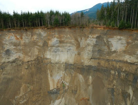
On Saturday morning (March 23rd) a huge section of the terrain slope north of the Stillaguamish River near the town of Oso failed, crushing a number of homes, covering portions of State Route 530, and caused a number of fatalities and serious injuries.  The pictures provided by Washington Department of Transportation are chilling (see below)

There is an interesting meteorological perspective I would like to briefly share here.

But first, let's get oriented.  The location is found in the western Cascade foothills, an area of often very heavy precipitation produced by air being forced to move upward by the terrain (area map below with oval in the slide area)

And here is a closer-inn view.

A major issue was the extraordinary precipitation of the past month.  Here is a map for the entire western U.S., showing the departure from average for this period:  the north Cascades stick out like a sore thumb, with anomalies of over 12 inches more than normal!


Percentage of average for the past month?  The north Cascades were above 300% of normal!

Or looking at the departure from normal in inches--big values in the North Cascades.

There were some very wet conditions earlier in the week.  Since there are not that many observations in the immediate area of the slide, lets look at the "storm-total" precipitation from the Camano Island radar encompassing the period from March 18th at 10:33 AM through March 21st at 3:36 AM.  The area in question got hit hard with at least 3-5 inches.


A nearby weather observing location in the hills behind the slide,  Finney Creek, has had 24.2 inches of rain this month.  This satellite image shows the location of the slide (red circle and Finney Creek observing site (red balloon symbols).


And here is the plot of precipitation at Finney Creek for the month so far: several days with more than two inches.


So we had a very wet month, topped off very heavy precipitation earlier in the week.


March 22, 2014

College Textbook Prices: Out of Control

It is a rare day when I agree with a Seattle Times editorial about an education subject, but today is that day.

The ST editorial is about out of control college textbook prices and how they are harming students.  And it's true.  In fact, even more disturbing than they describe.

Let me tell you a story.

A few years ago, I was scheduled to teach Atmospheric Sciences 101, with an expected enrollment of around 240.   Traditionally, my department had used the latest version of what we considered the best introductory textbook, one with a list price of around $130.   The U Book store planned to order a large number of  new books (which they sold at list) and have a modest number of used books at 30% off, around 95 dollars.  So perhaps they would order 150 new books.


I would inevitably get a call from a representative of  the company that distributed the book we generally used...and often several competitors.   Now keep in mind there was quite a bit of money at stake (130 x 150 = $19,500).

The book company representative called and told me about the many benefits of the latest edition.  But then it got seedy.   The representative offered to take me out to dinner...and yes, my wife was included.  And I could pick any restaurant in town.   I never accepted such offers--completely unethical.

I told the book representative that I planned to ask the University Book Store to only order  used books, acquiring additional copies on the market to get enough.  That a $130 textbook was a poor value. He said he would get back to me.

Then the next day the book company's rep called.  He said he had a special deal for me.  He would provide NEW books at a price less than the U Book Store's used price.   But to do so, I would have to either add or take away something from the book.  Add a few pages of my own or take away a chapter.  And they would change the title. In short, the same new book, but at a price just under the University Book Store used price.  A little surprising.

I agree to this deal..thinking I could save my student's some money.  But I played into the reps hands in one way:  my discount books would not be attractive to others on the used book market later and the students would have a harder time selling them back to the U Book Store...those book folks are clever!

And part of their corrupt little game is to produce new editions every year or so, even though 95+% of the books are the same.  So the "new and improved" book being pushed was hardly different than previous editions (I checked page by page).  But it would help undermine the used book market.

Smartening up a bit, my next time teaching the class I insisted on using only used books and told students to purchase any edition of the book of the past ten years.  And I told them to do their shopping online, since Amazon and others often sold $150 list books for $20-30 used.  Much cheaper than the used book price at the University Book Store. Parenthetically, my son, who was going to college at the time, bought all his books online, saving me a lot of money.

Now let me make the case that many of these textbooks are poor values.   Take a very popular book that we have used for Atmos. Sc. 101:  Ahren's Meteorology Today.  640 pages, lots of color. And     $ 161.48.   The electronic (Kindle) Version is $ 125.00.   Hard to believe.


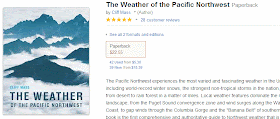
Compare this book to another good weather book, one I am kind of fond up (see below).   Just as good color graphics and quality. 281 pages. List price of $ 29.95 but available new for $22.00 (until recently 19.95).  Used books for 5-10 dollars.  Yes, my book.   And the University of Washington Press, the publisher, must have been selling the book to Amazon at substantially less than $20.00


So using the costs per page of my book, Ahrens should list for $ 68.00 and available on Amazon for around $50.00   But Ahrens is one of the most popular 101 books in the U.S. and has huge volumes...and thus should be cheaper. And virtually all the material is found in past (and FAR cheaper) editions.

How many ways can one spell R-I-P O-F-F?   To get faculty hooked,  Ahrens offers all kinds of extras for the instructor, like test questions, visuals, and homework questions.   Not much use for the student's though.

There are a number of other introductory atmospheric sciences book with crazy high prices, like this one at $135.00

As described in the Seattle Times editorial and in many other places, textbook prices have gone up much faster than inflation.   It has become a significant proportion of student education costs.  Many students are NOT purchasing required textbooks, something I confirmed last time I taught 101.   I try to ensure there are few copies in the UW library under short-term loan, but those are always checked out.

Why has the current system continued to exist?  There is certainly a lot of self-interest going on. Textbook companies make a killing.  Professors who write textbooks make a lot more royalties for expensive books.  And college book stores, which get a percentage of the transactions, bring in much more with high-priced books.   And book publishers play up to faculty with exam/hw materials, prepared powerpoints, and a lot more.  Everyone does well except the debt-laden student.

Fortunately, technology offers a way to deal with the problematic publishers.  Professors such as myself need to create books that are in the public domain and available electronically.  There are a number of groups working for free or inexpensive online college textbooks.

 I am trying to get my department to create an introductory meteorology  textbook.  We have experts in all major areas of atmospheric sciences.  Each of us could write a chapter on our specialty area, which would be easy for us since we know the material.   A pretty decent online book could be written is a few weeks that way, certainly at least as good, if not better, than the expensive ones shown above.  Perhaps we could charge $30 for it and use the money for an undergraduate scholarship.  I really hope my colleagues will work with me on this project.

And, if you think college textbook prices are a problem, K-12 text prices are just as bad.


March 20, 2014

When Is the Air Coldest Aloft? The Answer Might Surprise You!

When do you think the air in the Northwest is coldest above the surface, say at 5000 ft above sea level?

(1)  December 21st when the sun is weakest.
(2)  First week of January when the surface temperatures are lowest on average.
(3)  Early February
(4)  Now, mid-March
(5)  April 15th.
(6)  Late November when Northwest weather is most wet and windy.
(7) Mid-June, when the Northwest is the midst of lots of low clouds.

Time's up!  The correct answer is (4)...right now.   Bizarre isn't it?  Our coldest temperatures aloft are nearly coincident with the beginning of Spring (today!), when the sun is far stronger and daylight much longer than 3 months ago.

Don't believe me?   Here is a plot the climatological 850 hPa (roughly 5000 ft)  temperatures over western Washington by month.  The data is based on upper air data from 1948 to 2013 at Quillayute on the NW Washington Coast, nearby Tatoosh Island, and Seattle.  Take a look at the 50% line or the median temperature value.  The coldest month on average?  March! The extreme cold temperatures are in November through February (black line), but ON AVERAGE temperatures aloft are colder in March.  Who would of thought?
If you think about it, it all makes sense.   The sun strengthens after December 21st, and  a shallow layer at the land's surface starts to warm from the greater sun.  To put it more technically, the land's surface has limited heat capacity, the ability to store heat.   So it warms up rapidly as the sun's rays strengthen. That is why a sandy beach warms up so readily when the sun comes up.   And keep in mind that there is always cooling from infrared radiation emitted to space; warming only occurs when the solar radiation coming in is greater than the infrared radiation going out.

But now consider the atmosphere.  The air has a substantial mass and volume.  It has more heat capacity than the surface or what we call thermal inertia.  Think of huge flywheel....hard to spin it up and later to slow it down.

So the ground warms up relatively quickly, but it takes some time for the atmospheric flywheel to rev up from the sun's rays (and from the infrared radiation from the warmed surface below).   And around here there is another factor, during March and April we have less strong storms with powerful southerly winds bringing warm air up from the subtropics.  The flow is more westerly in the lower atmosphere, with a greater tendency to pull air from more northern climes.  The 850 hPa  wind maps for April and December illustrate this.

Now there are big implications for the differing heating rates of the surface and the air aloft during the spring....and you experienced the effects today if you were here in the Northwest.   With the surface warming up more rapidly than the air above, the difference in temperature between these two levels increases.  To put it another way, the rate of change of temperature with height...known as the lapse rate...becomes very large in spring around here.   And big changes in temperature with height leads to vertical instability and convection (cumulus and cumulonimbus clouds).  We have lots of instability and convective showers the last few days (like the picture below) as a result of the large springtime change in temperature aloft.


You can see all the spring instability clouds from the MODIS satellite.  Most of the white clouds in the image are convective clouds.


All of you have lots of experience with big changes in temperature causing convection:  in your hot cereal pot or the convecting water in your water for pasta. All examples of vertical instability produced by large changes of temperature in the vertical.

So because of the lag of warming aloft, spring is the most unstable time of the year, with the most change in temperature with height, and the most cumulus convection.  It is also the least foggy time of the year, since fog does not do well with large cooling in the vertical and vertical mixing.

And autumn is just the opposite.  The atmospheric flywheel keep the atmosphere relatively warm, while the land surface cools as the sun weakens.  The atmosphere becomes very stable, with lots of fog and the potential for air pollution.  Far fewer thunderstorms.


March 18, 2014

The Rapid Refresh Revolution

There is a major revolution developing  in weather prediction, something many professionals are becoming aware of and using, but relatively unknown to most others:  The Rapid Refresh Revolution.

How many times do you get the latest forecast over the web, radio, or TV and the short-term forecast is different than what is happening outside?  This is not rare, unfortunately.   We may be able to fix this.

Short-term forecasts are really important; they help us decide whether to take that bike ride, mow the lawn, take a run, and innumerable other tasks.   For folks worrying about wind energy, a good short-term forecast is worth huge sums and for those who maintain our roads, a good short-term forecast can make the difference between gridlock and a free-flowing highway.


Typically, the numerical weather forecasts made by major centers are only done every 6 hours (National Weather Service GFS and NAM models) or 12 hours (like the European Center for Medium Range Forecasts).   Since forecast errors increase in time, these forecasts are often a bit stale when we get them. Furthermore, many of the global and national modeling systems are run a modest resolution and are not started (or initialized) with a full set of local weather data.   The result of these and other issues is that short-term forecasts based on them are frequently unskillful, even in the short-term.

But some imaginative atmospheric scientists at NOAA's Earth System Research Lab in Boulder, Colorado have developed an alternative approach to weather prediction, one designed to optimize short-term forecasts:  the Rapid Refresh (RR)  approach (also called the Rapid Update Cycle).

In the current RR approach, high-resolution (13 or 3 km grid spacing) numerical weather prediction models (WRF model) are initialized and run EVERY HOUR using as many local weather assets as possible, including surface networks, weather radars, radiosondes, aircraft data, and others.  The model closely duplicates the detailed structure of the atmosphere at the starting time and then is run out 15-18 hours, not the days or weeks commonly used for the national or global models.

Begun at the Rapid Update Cycle in 1994 (60 km grid spacing, update every 3 hours), the Rapid Refresh methodology has been perfected over the years, particularly as computer power and high resolution data have increased.  5 years ago the Rapid Refresh methodology did not impress me, but during the past few years I and others interested in forecasting have noted a very large improvement in skill.   To put it succinctly, the skill of NOAA/NWS Rapid Refresh is now sufficiently accurate in the short term to be a game changer for short term forecasting.   But not perfect by any means.

There are two resolutions of the current  NOAA/NWS Rapid Refresh system, one at 13 km (called Rapid Refresh) and 3-km (the High Resolution Rapid Refresh or HRRR).  You can view these yourself here and here.  Every hour they construct a high-resolution analysis as well as short-term (15 or 18 h) forecasts of all major weather parameters.

Let's consider an example.  Here is the radar image at 2 PM on Friday.   The yellows are heavy precipitation.


Friday afternoon a very strong convective line developed over north Puget Sound and adjacent areas. Another line of heavy precipitation in eastern Washington.  

The HRRR two hour forecast had the Puget sound band in the right location and orientation, as well as a heavy band of rain in eastern Washington. Not too bad.


Compare the HRRR 2-h forecast to the 9 h prediction from the UW WRF, which was initialized at 5 AM.   The Puget Sound band is not there and the precipitation in eastern Washington is too weak.


This is not an exceptional case.   Today, the Rapid Refresh (13km) system is operational and available on National Weather Service web servers.  The HRRR is not operational, but only available in test mode.  The reason?  LACK OF COMPUTER POWER available to the National Weather Service operational center (Environmental Modeling Center).  You know what I think of that!

The Rapid Refresh approach will make possible greatly improved NOWCASTING, short term descriptions of what is happening now and in the near term.  Imagine a whole new generation of smartphone apps, showing you exactly what weather to expect in the next few hours.  Greatly enhanced renewable energy guidance for the hours ahead. A whole cottage weather industry could be built around such detailed local weather forecasts, and I suspect will.