And it happened last night. Here are some cam shots Sunday morning to illustrate. And the fun is not over yet.
We start with the parking lots of Mount Rainier's visitor center, where a snow plow is already at work.
Or at the Olympic Mountain's Hurricane ridge
Both of these locations are around 5000- 5500 ft, and so far the snow has generally been above 4500ft. But as shown by the latest aircraft reports over Seattle, the freezing level is still dropping, so snow could get down to 4000 ft today. In fact, there was even a light dusting at Steven's Pass:
The figure below shows temperatures (red lines) and winds (barbs) above Seattle over time (time increases to the left). Heights are in pressure (850 indicates about 5000 ft). The winds are westerly, which produces substantial upslope precipitation. Note that 0C (freezing) line has gotten down to 850 hPa (about 5000 ft). And snow doesn't melt immediately when it warms, it takes approximately another 1000 ft to disappear. That is why some snow got to Stevens, whose base is roughly 4000 ft.
The latest infrared satellite picture (8 AM, below) shows cool, instability clouds (mottled appearance, called open cellular convection) offshore, with a comma-shaped cloud mass making landfall right now. This kind of feature is a real snow producer!
The radar imagery at the same time show these cool showers clearly. They will reach the Cascades mid-morning.
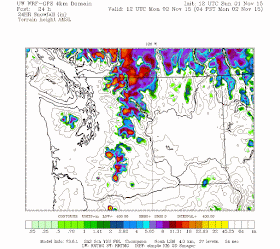
The latest model runs suggest substantial snowfall over the higher volcanic peaks and the north Cascades during the next 24-h. Some places may get more than a foot!
The National Weather Service has a Winter Storm Warning up for the higher elevations. The text will warm the hearts of all skiers and water managers (see below).
WAZ513-567>569-020000-
/O.CON.KSEW.WS.W.0004.000000T0000Z-151102T1900Z/
OLYMPICS-CASCADES OF WHATCOM AND SKAGIT COUNTIES-
CASCADES OF SNOHOMISH AND KING COUNTIES-
CASCADES OF PIERCE AND LEWIS COUNTIES-
437 AM PST SUN NOV 1 2015

...WINTER STORM WARNING REMAINS IN EFFECT UNTIL 11 AM PST MONDAY...

* SOME AFFECTED LOCATIONS...MOUNT BAKER...HURRICANE RIDGE...
  PARADISE...STEVENS PASS...WHITE PASS...RAINY PASS...CHINOOK
  PASS.

* TIMING...SNOW SHOWERS WILL FALL IN THE MOUNTAINS TODAY AND
  TONIGHT. THE HEAVIER SNOW WILL OCCUR TODAY...WITH INTENSE BURSTS
  OF SNOW LIKELY. SNOW SHOWERS WILL TAPER OFF MONDAY.

* SNOW LEVEL...4000 TO 4500 FEET TODAY THROUGH MONDAY.

* SNOW ACCUMULATIONS...TODAY THROUGH TONIGHT... HURRICANE RIDGE: 4
  TO 6 INCHES. RAINY PASS: 7 TO 13 INCHES. MOUNT BAKER: 7 TO 13 INCHES.
  STEVENS PASS: 2 TO 8 INCHES. SNOQUALMIE PASS: NO ACCUMULATION.
  CHINOOK PASS: 5 TO 10 INCHES. WHITE PASS: 4 TO 8 INCHES.
  PARADISE: 13 TO 20 INCHES.

* MAIN IMPACT...THIS WILL BE THE FIRST SIGNIFICANT SNOWFALL OF THE
  SEASON FOR THE HIGHER PASSES AND MOUNTAIN HIGHWAYS. TRAVELERS
  SHOULD BE PREPARED FOR SLIPPERY ROADWAYS...POOR VISIBILITY...AND
  POSSIBLE TRAVEL DELAYS ON THE HIGHER PASSES.


What was with the ridiculous NOAA release two days ago indicating "up to" 12-15 FEET of snow at the upper elevations?
ReplyDeleteThat was the forecast for the summit of Rainier, way up at 14,000 feet. Not sure it was ridiculous. Conditions up there, 10,000' above the freezing level even for this storm, can be unimaginable for those of us who spend our lives at 5500' or below.
ReplyDeleteaccording to the weather station up at Timberline ski resort on mt. hood oregon; since the 30th, it received about 15 inches of precip (probably mostly rain) at 5880 feet asl. checking temps at camp muir on rainier at +/- 10 000 feet showed subzero temps throughout that time period...sooo....if mt. hood had a similar freezing level as rainier, the top grand or so of mt. hood could have received a pretty good whack of snow... would be great to get some reports on this.
ReplyDeleteOn another matter: any insights or other thoughts on the weekend's news of the firing of "Monsieur Météo", the head of the weather desk for France's TV2? It seems he is deemed guilty of inciting the public to question whether the IPCC is politically motivated, as well as stating that the most common error made by media weather personalities is the conflation of newsworthy weather events with climate change.
ReplyDeleteThis comment has been removed by the author.
ReplyDeleteYes, LVDLM. This is why Climate Alarmists have already lost. No matter the importance of your cause, if you have to suppress dissent and thus use force to disseminate your ideas, you have already lost.
ReplyDeleteReal science does not require bullying.
Does anyone know if there ever been an attempt to deploy a Weather Station on the summit of Mt Rainier? If so, would there be any benefit to the Meteorological community to gather such real-time data?
ReplyDeleteI see that http://www.atmos.washington.edu/data/rainier_report.html provides estimated conditions with the disclaimer "TEMPERATURES AND WIND FOR THE SUMMIT AND CAMP MUIR ARE AVERAGE
CONDITIONS EXPECTED IN THE FREE AIR AT THOSE ELEVATIONS."
I have compared the real-time data from the Camp Muir weather station and the readings are usually a great deal different from the estimated data from atmos. Seems like it would be a nice to have. There are already hardened systems deployed in the Arctic from companies like Raytheon so surely the extreme environment aspect could be handled.