Getting some light snow in September over the higher elevations of the Northwest is quite normal, but what is about to happen over western Montana and southwestern Alberta, will be unusual--with several feet falling at some locations on the eastern side of the Rockies during the next week.
And here in western Washington we will get a taste of much cooler temperatures and a dusting over our high terrain.
Regarding the first date of snow, here is a wonderful graphic from NOAA/NWS (link ) providing the earliest first date of snow. Lots of locations with September and even late August dates in western Montana, eastern Oregon, the high terrain of Idaho, and the spine of the Cascades.
So now that the shock of potential snow is over, let's take a look at the latest forecasts for total snowfall over the next week--examining the forecasts of the European Center model and the UW WRF modeling system (below).
They are very similar...HUGE snow dump of 2-3 feet on the eastern sides of the Rockies. And a few inches to a half foot over the higher elevations of the Cascades. Eastern Oregon will get a thin veneer of snow.
The forecast temperatures at Seattle from the European Model show the abrupt change ahead. Mid-60s for a few days, but then highs of only around 55F on Saturday and Sunday, with a slow warm up after that. Rain late Thursday and more on Saturday. No snow for us!
But the story in Spokane is different. The bottom drops out there. A 20 degree drop in the high temperatures, with minima declining to below freezing. And snow is forecast there.
Missoula is something else. 25-30F drop, 9 inches of snow, minima below 20F.
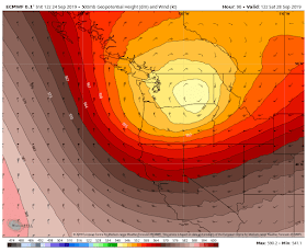
The cause of all this? An usually deep upper level trough that will move into our region from the Northwest (see 500 hPa upper level map below). Wow. I get shivers looking at it.


Why have all the stations stopped recording snowfall?
ReplyDeleteIt might be fun to start "a pool" (like a grid for sports scores). I've been tracking overnight lows for a few years since we had an overnight low of 39.7 F on June 22 2017. Here near Mt Baker (at near 1000'), the first hard frost in the fall of 2016 was Oct 11, in 2017 Oct 14, and 2018 Oct 4. First snow here: 2015 Nov 14, 2016 Dec 4, 2017 Dec 2, 2018 Dec 21. I once heard a mariner say, "Don't steer the boat by watching the wake." These old figures are probably meaningless. I'm far more interested in what lies ahead. Thanks for sharing the predictions. Fascinating!
ReplyDeleteCould this help to break up the North Pacific "Mini Blob"?
ReplyDeleteOpposite actually.
DeleteQuite easy to track the status of the Blob on the NOAA website. According to mine eye, subtle but notable cooling of sst's over the past few weeks in a pretty large portion of the NE Pacific. Looks like a slight rise in sst's in a smaller, concentrated area of the mid north pacific though.
Deletesept 2
https://www.ospo.noaa.gov/data/sst/anomaly/2019/anomnight.9.2.2019.gif
sept 23
https://www.ospo.noaa.gov/data/sst/anomaly/2019/anomnight.9.23.2019.gif
what needs to be updated is the old farmers almanac they say we will have a very warm winter but 1 foot in the cascades sounds like a snow event 2X the winter that happened this past winter it is supposed to get to 33 at my house again only up 500ft pluss above sea level like that crazy!!!!
ReplyDeleteThere was another old timer who said the two worst weather years were 1955 and next year.
ReplyDeleteThe Bow WA weather-reporting rock-on-a-string is ready for what comes.
Hey Cliff, my Mom lives on the east coast in Atlanta. Do you have a counterpart in that area who blogs like you do?
ReplyDelete