June 30, 2022

The Upcoming Inundation of Southern BC and Northern Washington. Plus Thunderstorms!

Southern BC will soon be hit by unusually heavy precipitation for this time of the year.    

And conditions before July 4th will be a damp affair, with a good chance of thunderstorms Saturday evening and Sunday morning. 

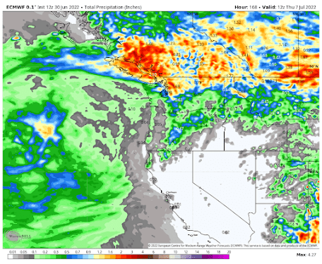
Let me start by giving you the big view:  the total predicted rainfall during the next seven days.  The European Center accumulated precipitation forecast through 5 AM next Thursday (below), shows considerable rain.. as much as 2-3 inches in southern BC, with the North Cascades and northeast WA getting a piece of the wet action


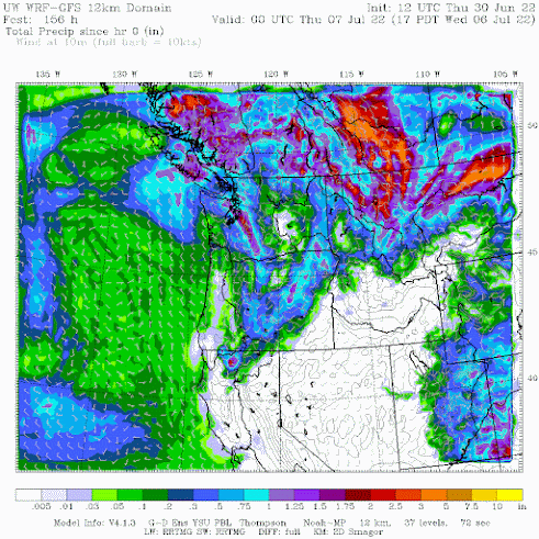
The University of Washington modeling system's forecast is similarly wet.  BC ducks will be happy.


The first big rain action will start Saturday night as an approaching upper-level trough forces a series of thunderstorms that will move northward out of Oregon.  

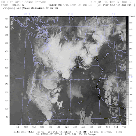
The uber-high resolution UW forecast model shows the simulated satellite image at 11 PM Saturday (below).  The most active thunderstorms will be over the Cascades and eastern WA, but western WA should get a taste of it.


Sunday will be a showery day, and on Monday (July 4th) most of the rain will be in eastern WA and far eastern WA.

The silver lining of the weekend rain is that the ground will be wetted down before all the firework activity on July 4th, reducing the potential for unintended wildfires and home destruction.

I should note that the cause of the weekend rain is similar to the origins of our wet spring:  a persistent offshore trough of low pressure.

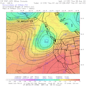
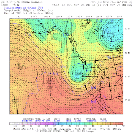
Here is the upper-level (500hPa pressure, about 18,000) map at 11 AM Sunday. A strong trough/low is centered just east of Oregon.


Next Thursday?  The same feature is in place.  This is a cool, wet pattern for us.  And it is not going anywhere.


With a lot of rain over an already moist southern BC, wildfires there will be suppressed in that province through a good part of the summer.  

This is very good news for us in Washington State.  BC fires have been a major source of recent summer smoke.

But not this year.


June 28, 2022

An Unnecessary Tragedy: The New Mexico Hermit's Peak Fire

On April 6, a wildfire was accidentally ignited by U.S. Forest Service personnel doing a prescribed burn near Hermit's Peak, New Mexico. 

A prescribed burn is a deliberately set fire intended to reduce the potential for catastrophic wildfires by burning off surface fuels during conditions unlikely to cause an uncontrollable wildfire. 

This Hermit's Peak fire began about 30 miles east of Santa Fe and 15 miles northwest of Las Vegas, NM.  Joining another escaped fire two weeks later (the Calf Canyon Fire), the Hermit's Peak fire has now burned 342,000  acres and destroyed over 900 structures.  

The area of the Hermit's Peak/Calf Canyon Fire as of June 27

The cost of fighting the fire is now over 250 million dollars and the total damage, all the responsibility of the Federal government, will easily range into the billions of dollars.  

Satellite image of the fire area last week.  
Red indicates burned area and bright orange shows active fires.

As I will describe below, none of this had to happen.
 
Inadequate use of meteorological forecasts and data, ignoring the large amounts of preexisting flammable surface fuel, and poor decision-making all contributed to this disaster. Climate change was not a major player in this wildfire, in contrast to the suggestions by certain media (e.g., Washington Post, Seattle Times) and some Forest Service officials.

Last week the Forest Service put out an official report on the incident.  Although there was an admission of some deficiencies (like not having firefighting capability in place if the prescribed burn went wrong), the report provides an inadequate description of the conditions leading up to the fire and did not note the failure to take advantage of modern meteorological prediction tools. It also suggested, erroneously, a major contribution of climate change.  

This blog will tell the real story.

Dangerous Accumulation of Flammable Fuels Before the Fire

Prior to the fire, the accumulated amount of surface fuels (e.g., grasses) was far above normal and very dangerous.   This was documented on one of the Forest Service's own websites (fuelcast.net) and a specific warning of the danger BEFORE the fire was given by a leading Forest Service surface fuel expert, Dr. Matt Reeves.   

Heavier than normal precipitation last summer during the Southwest Monsoon led to abundant grass growth, which dried out during the winter and spring under the influence of a moderate La Nina (which causes the southwest U.S. to be dry during the cool season).  Neither of these conditions is associated with global warming.

Dr. Reeves (on March 1) noted that surface fuel density in eastern New Mexico was above normal (yellow and green colors in the figure below), representing a substantial wildfire threat.  The location of the Hermit's Peak fire is indicated by the black arrow.


A Strong Wind/Drying Episode the Day Before the Fire

On the day before the fire, there was an intense drying event, with very strong, low-humidity, desiccating winds over the region.  This is illustrated by the Hot-Dry-Windy index that combines wind speed and atmospheric drying potential (values shown below are for the area around the fire). 

A HUGE spike of drying conditions occurred on April 5th.   Think of it as a drying storm that quickly sucks the moisture out of dead grasses and other vegetation.


This intense drying was evident at a nearby U.S. RAWS weather station (Pecos, NM), where the winds gusted to 40-50 mph and the relative humidity dropped to under 20% on April 5th.   Any grasses or light fuel were completely and utterly dry after the "drying storm."


An Ominous Weather Forecast Ignored on April 6th

Now we get to the day of the prescribed burn and runaway wildfire.

According to the official Forest Service report, there was no dedicated meteorological support for the burns and the only guidance was a few spot forecasts requested from National Weather Service forecasters in Albuquerque.

The Forest Service report states that the key reason why the fire got away from Forest Service personnel was "variable and shifting winds."    The truth is that such winds were clearly forecast well before the prescribed burns were initiated during the late morning of April 6.

Consider the operational National Weather Service HRRR forecast model, which is run at high resolution over the entire U.S. every hour, providing timely and accurate high-resolution weather prediction.  These predictions were available to the Forest Service folks well before the burn.

Below are the HRRR forecasts of surface wind gusts.  This forecast model run was started at midnight Mountain Daylight Time (MDT) and would have been available on the web by 2 AM April 6th (well before the fires were initiated by the Forest Service).  The plots below show forecast wind direction and wind speed (plotted by UW research meteorologist Jeff Baars).

At 6 AM MDT, the predicted wind gusts were from the south near and east of Hermit's Peak, reaching 15-20 knots  Winds were variable near the peak with strong northwesterly winds to the west.

By 11 AM winds had greatly strengthened to the east of Hermit's Peak and a surge of strong northwesterly winds began to push over the terrain just to the west of Hermit's Peak.  A major wind shift and wind strengthening were about to occur.  This is when they decided to light many of the fires.

By 3 PM, when the prescribed fires were starting to go out of control,  northwesterly winds were predicted to hit the Hermit's Peak areas, with gusts to 20-25 mph.  As shown by the observations at Pecos RAWS (shown above) and other local observing sites, this was a good forecast.
To further illustrate the realism of the forecasts, below are the maximum gusts on April 6th.  26 mph at Pecos and 31 mph at Las Vegas, NM.  

Maximum wind (mph) on April 6 in the fire area.

The substantial change in winds was also forecast by the National Weather Service National Blend of Models (NBM).  Below are the forecasts for the Las Vegas, NM airport,  made at 1 AM the DAY BEFORE (the times are all in UTC/GMT).  

The gusts (GST) were predicted to be as high as 24 knots that afternoon.  And the wind direction  (WDR) was predicted to shift from southerly (17, 18) in the morning to northerly and then northwesterly (3, 5 to 34, 33) later in the afternoon.


The bottom line is that increasing winds and wind shifts were clearly predicted by the National Weather Service HRRR model and the NWS NBM system well before they occurred, and subsequent forecasts enhanced the threat further. 

Thus, the strong, gusty winds with changing directions should NOT have come as a surprise to Forest Service personnel.

But it is worse than that: the air predicted to come across the terrain west of Hermit's Peak was far drier and thus more prone to burn.

The observed relative humidity plot at the nearby Pecos RAWS site (repeated below, Local Standard Time shown), shows this profound drying, with relative humidity dropping to BELOW 8% during the afternoon of the 6th.


Weather model forecasts the day before clearly showed the very, very dry air coming across the terrain from the west.  Below is a high-resolution forecast (starting 6 PM the DAY BEFORE) of relative humidity.

The forecast for 6 AM shows moderate relative humidity (50-60%) around Hermit's Peak. 


By noon, MUCH drier air was forecast (correctly) to move in, with values less than 25% at Hermit's peak and much drier air just upstream.


And by 6 PM, values were down to 10% and below.


Putting it All Together

So the morning of April 6th, Forest Service personnel made the decision to go ahead with a prescribed burn:

1.  With surface fuel loading was much higher than normal.   
2.  The day after a severe drying event was taking place.
3.  When National Weather Service operational forecasting guidance predicted a major wind shift and strong winds during fire operations.
4.  When National Weather Service operational forecasting guidance predicted plummeting relative humidity during the burn period.

Furthermore,  Forest Service personnel did so without dedicated meteorological guidance and did not ensure that there were sufficient firefighting resources to deal with an out-of-control fire.

These actions were not responsible and did not reflect the high standards expected of the USDA Forest Service.   

These actions not only resulted in billions of dollars of loss, the disruptions to the lives of thousands of New Mexico residents, and the loss of valued natural and historical resources but also undermines the critical task of responsibly restoring the dangerously fire-prone western forests, damaged by decades of fire suppression and mismanagement.

Finally, there should be a special place in Hades for those in the media and in the government that blame such forest mismanagement and prescribed burn missteps on climate change, as illustrated by the article and headline below in the Seattle Times. Such misinformation/disinformation undermines our ability to fix western forests and puts people and the natural environment at risk.
June 26, 2022

A Very Green Start of Summer

What a difference a year makes.  The bountiful precipitation and cool temperatures have resulted in a far greener Washington and Oregon east of the Cascade crest.

Let me show you.

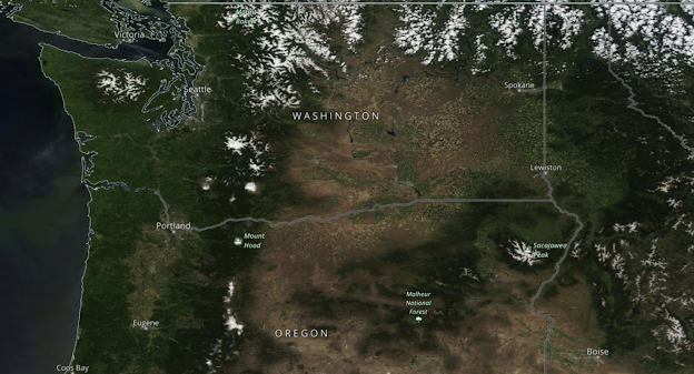
Consider the visible satellite picture yesterday (see below)

2022

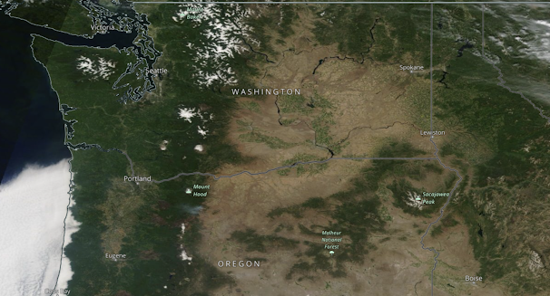
Now compare it to one year ago.

2021

The differences are substantial.   

Do you see how much greener southwest Washington and northeast Oregon are?   Pay particular attention to the eastern side of the Columbia Basin.

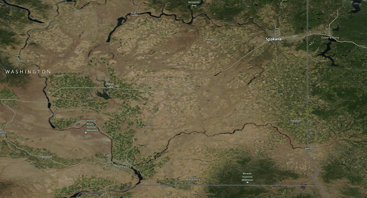
To show the difference even more clearly, let me zoom in on the southeast portion of Washington State.  A lot more fields are green--and many of these are wheat and barley farms.

2022


Although there has been a lot of talk of drought and problems for dryland farmers in eastern Washington, the truth is that things look good.  

But don't take my word for it.   Below are the statistics available from the Washington Association of Wheat Growers and taken by the Federal National Agricultural Statistics Service data collection as of June 19th.  The condition of spring wheat is 89% good or excellent, for barley 86%, and peas 88%.  Winter wheat that began during the dry winter is 71% good or excellent.

Winter wheat:
1% very poor
4% poor
24% fair
58% good
13% excellent

Spring wheat:
0% very poor
3% poor
8% fair
81% good
8% excellent

Barley:
0% very poor
1% poor
13% fair
77% good
9% excellent

Dry edible peas:
0% very poor
1% poor
11% fair
85% good
3% excellent

In short, dryland cops in eastern WA seem to be in good shape.   There are some crops that have been damaged/slowed by the cool/wet conditions such as cherries.

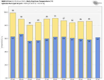
After we finish this mini heatwave tomorrow (Monday), expect normal conditions on both sides of the Cascades (see temperature forecasts for Seattle and Ephrata below).  Low to mid 70s will dominate western Washington.   Close to perfect.   And I might note there are NO significant fires anywhere in the Northwest.

Seattle Temperatures


Ephrata Temperatures


June 24, 2022

Weekend Warmth and the Secrets of Northwest Heatwaves: All in My New Podcast

This weekend is going to be the warmest of the year so far in the Pacific Northwest and my podcast provides the details.  

 But  I don't stop with the forecast:  in my second segment, I tell you how difficult it is to get a heatwave in western Oregon and Washington because of the cool Pacific Ocean and the specific conditions needed to push us into warm territory.

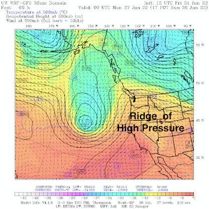
The key feature promoting weekend warmth is an upper-level ridge of high pressure that will develop over us on Saturday and Sunday (see upper level...500 hPa pressure...about 18,000 ft...for 5 PM Sunday)


At the surface, this situation is associated with high pressure inland that produces easterly (offshore-directed) flow that pushes the cool marine influence out to sea.   This is shown by a surface map at 5 PM Saturday, with colors showing temperatures and pressures by solid lines.


The latest forecasts for surface temperature show the warming.

5 PM Saturday:  Temperatures in the 80s or more are found in the Columbia Basin, southwest Washington and into Puget Sound.


Even warmer on Sunday, with 90s (pink colors) spreading from the Willamette Valley into SW Washington as well as in the Columbia Basin.


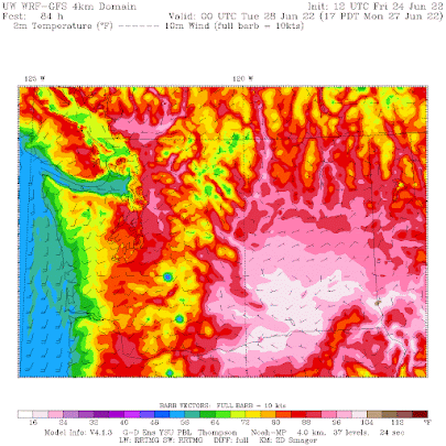
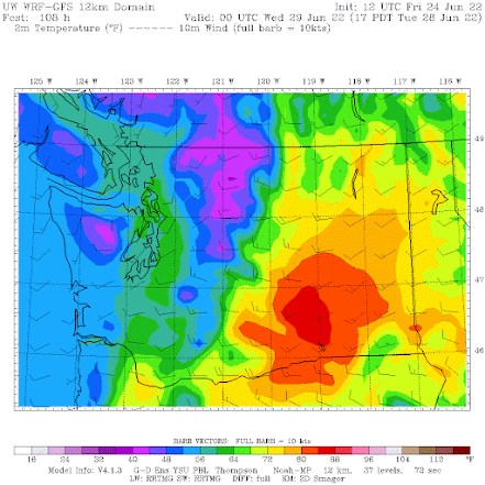
Monday's 5 PM temperatures suggest major changes. Very hot in the Columbia Valley (more than 100F) and profound cooling along the immediate coast.  The marine air is moving back in! Perhaps the warmest day in northern Puget Sound.


And Tuesday afternoon will be profoundly cooler in the west.  Wow.  You might need a sweater!


To listen to my podcast, use the link below or access it through your favorite podcast service.


Some major podcast servers:

 HTML tutorial HTML tutorial
Like the podcast? Support on Patreon 


_____________

Announcement

   I will be giving a talk on Northwest Weather and signing copies of my updated book (Weather of the Pacific Northwest) at the Northgate (Seattle) Barnes and Noble at 1 PM on Saturday, June 25th.  

June 23, 2022

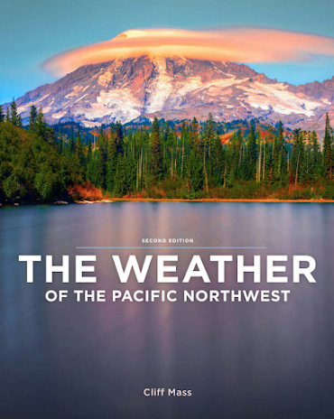
My Saturday Weather Talk in Seattle and the New Edition of Weather of the Pacific Northwest

I am excited about the possibility of doing in-person bookstore talks again...and I am beginning with one at the Barnes and Noble in Seattle (Northgate) at 1 PM this  Saturday (June 25th).  More information here.  It will be very good to talk to people in person.

My talk will describe some interesting aspects of Northwest Weather, including the origin of June gloom, Northwest heatwaves, the rapid transition to summer in late June or early July, and much more.    I will also note the heavily updated version of my Northwest Weather book (see below).  I will be happy to sign and personalize any copies of my book you purchase at Barnes and Noble or bring with you.


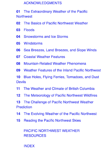
The new version of my book is entirely updated with recent storms and weather events, and I have added two major chapters:  one on the meteorology of Northwest wildfires and the other on the weather of British Columbia.  I completely rewrote the chapter on climate change in the Pacific Northwest.  The outline of the book is found below:


More information on the book can be found at the Barnes and Noble and Amazon websites.  

See you on Saturday.

June 21, 2022

A Very Pleasant Heat Wave Ahead

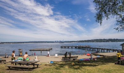
Although the term heatwave has recently become a word that provokes fear and anxiety, a short, moderate heat wave can be very pleasant.

A time for swimming, icy drinks, and hanging out at a local park.


This week we will enjoy such a welcome period of warmth.  In a real sense, we are about to cross a meteorological rubicon from a cool/wet spring into mild/dry summer.

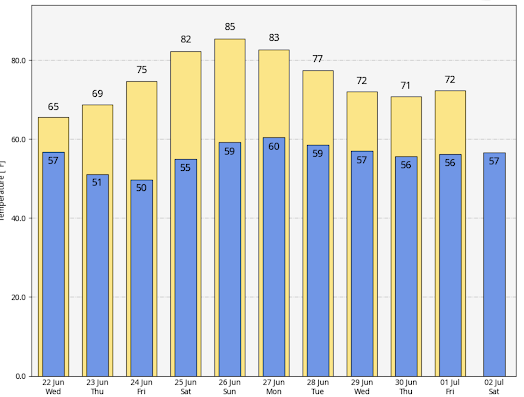
Below is the latest National Weather Service forecast for Seattle.   We have one relatively dreary day ahead (Wednesday), with a high of 65F.   Thursday is the transition day.  Friday will be in the mid 70s and Saturday through Monday will bring highs into low to mid-80s.


And after our "heatwave", there will be day after day in the 70s.

The warm period will be associated with the development of a moderate upper-level ridge along the West Coast, illustrated by the upper-level (500-hPa pressure level, about 18,000 ft) map at 2 AM Sunday (see below).


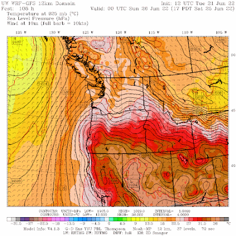
The surface map at 5 PM Saturday, during the first day of the warmth, has high pressure inland, easterly (offshore-directed) flow, a trough of low pressure extending from California northward into western Washington.  The classic warm pattern (the solid lines are sea level pressure and near-surface temperature is shown by colors).


This heat wave will be quite typical for this time of the year and will have little in common with the great heat event of late June 2021.

The latest extended forecasts suggest a profound change in the weather.

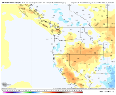
Temperatures over the next 30 days are predicted to be near normal  (see below)


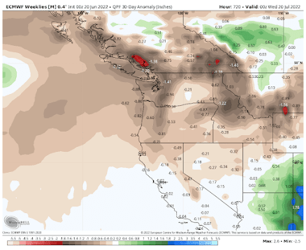
While precipitation for the next 30 days is forecast to be below normal for most of the region.


_____________________________

Announcement

   I will be giving a talk on Northwest Weather and signing copies of my updated book (Weather of the Pacific Northwest) at the Northgate (Seattle) Barnes and Noble at 1 PM on Saturday, June 25th.  


June 19, 2022

Northwest Weather: Darkest Before the Dawn

Announcement

   I will be giving a talk on Northwest Weather and signing copies of my updated book (Weather of the Pacific Northwest) at the Northgate (Seattle) Barnes and Noble at 1 PM on Saturday, June 25th.  

___________________

It is a well-known aphorism that it is always darkest before the dawn.   

And this wisdom may prove particularly applicable to the weather situation this week.  A major  improvement will soon occur

But first, let's talk about darkness.

330 PM Friday in Seattle.  It rarely gets worse than this in June.

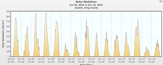
On Friday, Seattle only received 4.64 MegaJoules per square meter of the surface (Joules are a unit of energy).    This is the darkest June day since June 2014.  June 9th was almost as dark.  And Saturday was only slightly brighter.  

Full sun this time of year should be around 900 watts per square meter.  
We have had several days with half that much

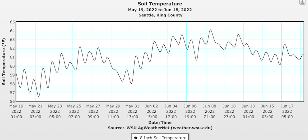
With cool, cloudy air over us, soil temperatures have stopped rising and started to decline, as shown by the soil temperatures at 8 inches in Seattle (below).   Your tomato plants are not happy.   No one is happy.


But I have good news.   Leading weather forecast models suggest we are going to break out of this infernal situation, at least for a while.

The Key Problem

The main reason we have been so cloudy, wet, and murky has been persistent low pressure or troughing along or just offshore of the West Coast.   Below is the upper level (about 18,000 ft) weather map for 11 AM Friday.   

Mama Mia!   A huge, high amplitude trough along the West Coast.  No wonder it was dark and abysmal around here.   

A persistent trough of one kind or another has been in place the last few months.  And this situation is about to change.


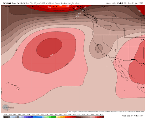
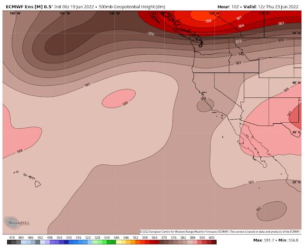
Examining the most potent, skillfull extended forecasting modeling system is the European Center's ensemble forecasting system.   Its latest forecast suggests that the upper-level trough will move inland a bit and weaken by Tuesday morning (pink indicates higher pressure--ridging, brown indicates lower pressure--troughing).  That will produce improving weather over the Northwest.


 On Thursday, a strong trough will pass to our north and a weak trough will remain over California. This will produce some decline in our weather.


But things look better on Saturday, as a deep trough develops well offshore and weak ridging extends along the coast.  A very different and MUCH more favorable pattern.


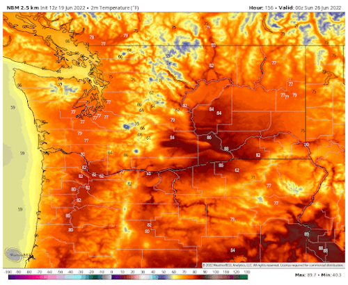
Sit down before I tell you the forecast for next weekend.    Saturday's temperatures, predicted by the National Weather Service Blend of Models (below), show the upper 70s in western WA and mid to upper 80s in the Columbia Basin.  Sunday will be nice as well.    It will seem like Paradise after what we went through the last few months.


And one more thing, based on the latest extended models, there is no hint of any possibility of getting a crazy heat wave like last June.   That was a black-swan event that will probably not happen again for many decades.