Next week, startling weather contrasts will develop across the Cascades.
Frigid, Arctic air will settle into the Columbia Basin, topped by low clouds. Temperatures there will fall into the single digits and sea level pressure will be very high due to the cold dense air.
In contrast, although a bit cooler than normal, temperatures over the western lowlands will reach the upper 30s. But downstream (west) of gaps in the terrain (such as the Columbia River Gorge) VERY strong winds will pummel localized regions in the west.
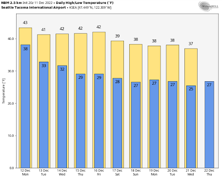
To illustrate, below are the forecast temperatures for Seattle and Richland for the next week or so from the National Weather Service blend of forecast models.
Here in Seattle, highs in the low 40s will rule through Friday, followed by a decline to the upper 30s. Freezing temperatures at night.
Cold but tolerable.
But consider Richland in the Tri-Cities.
By next weekend the highs will only rise to around 20F and lows will decline into the single digits. The coldest spots in eastern WA will drop below zero.
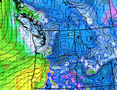
The cold, dense air in eastern Washington will result in the development of high pressure in the Columbia Basin. Here are the forecast sea level pressure (solid lines) and low-level temperatures (colors, blue and purple are the coldest) for Thursday afternoon.
You notice the intense pressure variation (gradient) over the Cascades. Large pressure changes drive winds. By late next week, very strong easterly winds will develop in the passes and in the Gorge (over 60 mph)
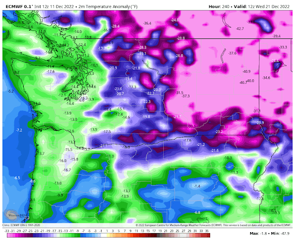
By Wednesday, December 21st, uber-cold air will settle into eastern Washington, with morning temperatures 30 to 40 degrees below normal (the forecast map below shows the difference from normal surface air temperature). A balmy 13F below normal in western Washington.
And yet this pattern will be dry. What is the cause?
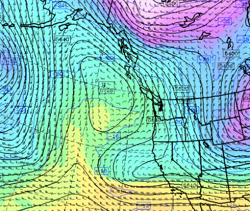
Our old friend this fall: a strong upper-level ridge of high pressure over the northeastern Pacific, which has powerful, northwesterly flow on its eastern side (see below for late Thursday)
This flow from the northwest will bring very cold air southward east of the Rockies, and a serious slug of it will get into eastern Washington. But no precipitation.
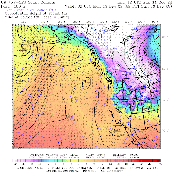
To really impress you, below is the forecast map of temperatures, winds, and heights at 850 hPa pressure (about 5000 ft) for Sunday evening. Purple is very cold, and white is very, very cold. I would not want to be in central or eastern Montana.
A very appropriate way to start winter.



That ECMWF temperature departure map is way,way, exaggerated. For example,the normal minimum temperature for Spokane on the 21st is 23 degrees.If one was to believe that map,then the minimum temp that day would be minus 17 F.The record low for that date is minus 10,which was set in an extraordinay 1983 cold spell that also produced a record low of 9 at Sea-Tac.
ReplyDeleteIt also should be noted that Spokane has not had a below zero reading in nearly four years.
Additionally, I believe that forecast map does not take into consideration the air stagnation and widespread fog and low clouds that often prevail in especially, Eastern Washington during high pressure episodes.
The current forecast is for temps bottoming out maybe in the single digits for most areas,unless extremely favorable conditions( no fog or wind).The exception would be in the higher northern valleys,which usually are above any fog,and currently have a deep snow cover to facillitate rapid radiational cooling.
That is one forecast. But virtually all are going for unusually cold conditions over eastern WA is a week.
DeleteThe bottom line is that we have to take models--even the better ones--with a grain of salt if they are more than 2 or 3 days ahead of the forecasted event.
DeleteStart winter? You mean his is only the start? I'm tired of winter already!! Those turtles of mine have the right idea: Just sleep it away, and emerge in April...
ReplyDelete