We continue to run much warmer and drier than normal and this persistent pattern will continue this week.
Yesterday we had very warm air above us, but the fog and low clouds held in sufficiently to prevent temperatures from climbing into the 60s except for a few favored areas (like North Bend, where I was biking yesterday). But still, much of the area got into the mid to upper 50s and only a little morning drizzle to dampen things.
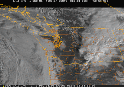
Today the warm air is still around, with a mixture of sun (over Seattle and Olympia) and clouds (along the coast and the western foothills of the Cascades)--check out the latest visible satellite image attached. Looking at this satellite picture, I would think it was June, not December. Lots of low clouds on the coast..and these clouds are moving westward...like a summertime onshore push. On the far western border you can see some higher clouds associated with a Pacific front
This front will cause increasing clouds this afternoon, with rain coming in around dinnertime. Showers tonight, with some hanging on into tomorrow morning...particularly on the mountain slopes.
Later Tuesday into Thursday, ANOTHER ridge of high pressure builds in with more warmer than normal, dry weather. Forget skiing. No significant snow this week.
what time do you eat dinner? or is that a safe way to say between 3 and 8pm.
ReplyDeleteWhenever the rain starts! Today I will eat crow...the rain came in early....about 3:30 PM....
ReplyDeleteohhh I should also say this is by far one of my favorite sites on the net. Thanks for all the great info and help in dodging the rain!
ReplyDelete