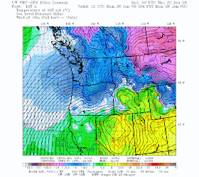
Several of you have commented on the potential for a transition to much colder air over the weekend. I have held off talking about it until we were close enough, but now it seems clear we will move to much colder air overhead later on Saturday. By Monday will be deep in moderated arctic air (see forecast output for 4 AM Monday). Blue indicates air cold enough for snow.
By Sunday AM we will be cold enough aloft for snow..but there is a real question on how much precipitation will be around. The latest runs only indicate light snow south of Seattle. The current forecast configuration does not look amenable to a significant snowfall. I will update much more on this tomorrow.
Cliff, will that still be part of the inversion and stagnant air over us, or will we get some movement? Thanks, Morgan
ReplyDeleteCould a Convergence Zone save us on Sunday?
ReplyDeleteNo..this will not be a stagnant situation...
ReplyDeleteand not a convergence zone situation...winds will be from the wrong direction
Noooooooooooooo! I'm freezing all the time now and it's gonna get colder?
ReplyDeleteI have a question for anyone who might know the answer. My home is in Maltby, kids go to school in Monroe and I go to the UW Bothell. It has been sunny and beautiful in Bothell the last few afternoons but by the time I get to Monroe it's foggy and dark and has been all day long. Why? Is it the river? Mountains? Punishment for the prison inmates?
Need to call on Fūjin, the Japanese god of the wind. He could be messing with you in Monroe…Ask him what the deal is….
ReplyDeleteI'm hoping for snow, but looks like it might just be cold and cloudy.
ReplyDeleteRegarding fog, every day this week on the way home I've noticed fog starts right around 180th and hwy 9 (going north on hwy 9). It gets thick starting at that intersection and stays thick all the way to my home in lake stevens.
It's been below freezing every night for...maybe weeks now in lake stevens and we haven't seen any sun up there in a while.
Wow, look at everyone getting excited for more snow... IDK about you guys, but I think I've had my fill of the white stuff in the lowlands for the winter. I like having the opportunity of driving 40 miles east on I-90 to have fun in the snow when I want to.
ReplyDeleteI think I'd choose snow over fog any day! At least it's brighter! The fog is so depressing....just a boring, gray, ho-hum pattern....It's funny how when it was forcasted to snow in December that everyone was sooooo excited. Then, after more and more and more snow, everyone wanted it to go away. Now we're all getting excited for snow again....oh, how short our memories are! I just hope we get a few more good storms (wind prefferred!) before spring. And hopefully spring gets here on time this year so I can plant my garden on time! :)
ReplyDeleteAnyone know the last time we had a signifcant lowland snow event in February? I'm thinking 2001 (if you exclude the North Seattle-to-Everett event of Feb. 28, 2007). So maybe all hope for more snow this winter is not lost...it seems we're a bit overdue for a February blast.
ReplyDeleteI to would rather see winter snow over fog any day during the winter months.
ReplyDeleteAs far as snow goes, it`s really looking pretty minimal as both the operational GFS models along with WRF-GFS this morning are going pretty dry with this upcoming event. 925mb temps Sat afternoon evening really lookto take plunge and dip to around -7c with NE flow. And with WRF showing 700mb moisture/humidity content of 20-30%, you know the cold air air mass will be really dry. NAM models also look a bit dry, but still show at least an inch or snow for Sunday per the simulated radar graphics.
-----------
As for today....pretty cold out there. Cloudy/low clouds and 33 degrees here on Hollywood hill in Woodinville.
At my elevation 400 feet, I do not remember a MAJOR snow event starting after the end of January. This is not at all true for a friend 500 feet higher. My major snow event I mean one that results in days of school missed + higher heating bills + stays around for some time + difficulty driving more than just in the early morning.
ReplyDeleteThe first specific storm I can remember along with a date was the near blizzard we experienced in January 1950. I remember at least a couple deep snows as a toddler type previous to that. Rob
Rob,
ReplyDeleteWhat about February 1989?
In recent memory, March 7-8, 2002 was pretty good for the Central Sound. It only canceled ONE day of school, though. Same with February 16, 2001. On both days, the snow started melting by noon. February 1989 was different.
In Bellingham, we had a foot of snow on the first day of Spring, 2002.
ReplyDelete