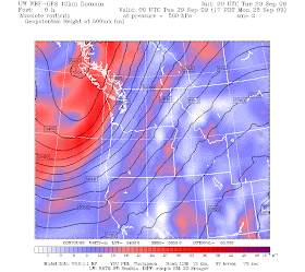

The front made it in late this afternoon and early evening as shown by the infrared satellite photo above. Winds really increased this afternoon as the front approached as winds reached 20-25 mph in places. If you look carefully, you will see the mottled cloud pattern over the ocean...those are the classic postfrontal instability showers produced by cooler air aloft over warmer water. You will notice an area of enhanced showers out there...that is associated with an upper level trough (see map for 500 mb, the lines give the height of this pressure above sea level). So expect showers and sunbreaks tomorrow.
The latest radar image shows the frontal precipitation on the east side of the sound and an area of enhanced showers from Sequim to Whidbey Island...this is from a convergence zone to lee of the Olympics...since winds are now from the SW aloft. All convergence zones are not over Puget Sound! It all depends on the wind direction.

The forest service decided to to a controlled burn up on White Pass yesterday. It blew all it's smoke into Yakima which made for an eerie site at sundown as the city looked vacant.
ReplyDeleteThanks for that info mainstreeter! That explains something I saw yesterday.
ReplyDeleteSpent the weekend in the scablands/dry falls area. High winds pulled all the dust from tilled farms up thru the canyon on Fri/Sat that fully obscured the Sunlakes canyon when you looked down canyon/SW direction. It was surreal. I've never seen it that bad.
But on the drive home yesterday, entering Ellensburg there was this huge ominous, nasty looking yellow column of "cloudy" stuff moving northward. It was so murky and unhealthy looking; worse than dust. Now I know what it was!
Excellent posts--I'm enjoying your Weather class! (ATM S 101)
ReplyDelete