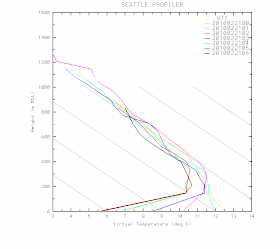
 Temps in degrees C and height in meters. The yellow line was for 4 PM...no inversion then. But you see how quickly the inversion forms after that...evident by 6 PM, and strengthens after that. It doesn't have to be dark for the inversion to start forming, you just need more outgoing infrared radiation than incoming solar radiation to do the trick. Look how shallow the inversion is! Roughly 200 meters, 600 ft. By 10 PM is was 6 C (around 11 F) warmer 600 ft up.
Today, many locations got into the upper 50s to near 60F. And something else happened...the winds picked up a bit. Below are the observations taken at the UW for the last 3 days. All with super sun and warm temperatures. The solar radiation is at the bottom...they looks like something out of textbook...no cloud effects. The wind speed (sustained and gusts) are at the top. Notice something? Winds tend to be strongest during the warmest time of the day. Why do you think that is?
The reason is at least two fold. The most important is that heating at the surface causes the air to be less stable with more up and down mixing. That mixing brings down stronger winds from aloft. Why stronger aloft? Less impact of friction and drag at the surface. The other reason winds pick up is that differences in heating between land and water and lowland and mountains produce diurnal winds (sea breezes, mountain-valley winds, etc) that increase wind speed.

Tomorrow will be the final perfect day. The last April day in February. On Tuesday a weather system will approach with a chance of showers later in the day. Then we switch into a cloudier, wetter pattern...but not too extreme. The El Nino impact is still clear, with the jet stream splitting to the north and south. We get some clouds and a few showers. Nothing interesting.
But I did but a lot of vegetables in today and planted my peas. Will they germinate? Will my lettuce and kale grow? If this keeps up it will be time for tomatoes in a few weeks (just kidding!).
I do hope your veggies grow! I spent some time getting my garden ready this weekend - lots of digging and work to do. I'm a bit wary of planting too much, but the NOAA extended forecast looks positive for above average temps the next couple of months. Can I be certain? I don't want to go too crazy, then lose things...
ReplyDeleteHi Cliff-
ReplyDeleteWhenever you post height vs. virtual temp data (usually to illustrate an inversion), I notice you frequently use observations made at Sand Point. How are these measurements taken? I can't imagine they launch weather balloons under the SEATAC flight path. How does one otherwise measure the temperature at multiple elevations?
Inquiring minds want to know.
Cheers,
Dan
By the acoustic measurement of the velocity of sound (which varies with temperature).
ReplyDeleteThink of an upward pointing doppler radar (or sodar) coupled to a sound generator. Measurements are taken at zenith and tilted from zenith. The device can determine both wind speed and direction at given heights and with the sound generator can measure sound velocity by height which can be converted to temperature.
Not sure which one they use at KSEW (but as the vertical range seems to be limited to 2km it might be either a 915MHz radar. It's at Sandpoint.
http://en.wikipedia.org/wiki/Wind_profiler
http://www-das.uwyo.edu/~geerts/cwx/notes/chap15/profiler.html
http://amsglossary.allenpress.com/glossary/search?id=wind-profiler1
Thanks Kevin. That makes perfect sense.
ReplyDelete