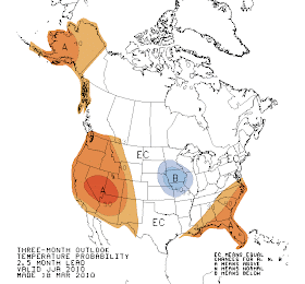
Quite a few of you have emailed me asking about the summer forecast. What does one expect in an El Nino year? Is there any useful guidance for planning that summer outing or party?
Let me begin by being honest: forecast skill for summer made this far out has only marginal skill. Now that won't stop me from telling you what the official and unofficial forecasts are, but please don't depend on them for anything critical.
And keep in mind that summer generally start around here a week or two after the July 4th weekend. The inside joke in the local weather community is that summer starts on July 12th, and this is often pretty close. It is true that we are in an El Nino pattern right now (warmer than normal water in the tropical Pacific), but it is only a moderate one and our forecasting tools suggest that it will weaken rapidly this summer. Besides, El Nino does not correlate that well with our summer weather.
The National Weather Service's Climate Prediction Center provided the following forecast for this summer (June, July, August) temperature and precipitation. To create the forecast, NWS forecasters use many tools: El Nino/La Nina, historical trends, an ensemble of long-range weather forecasts, and much more. You note that they are going for above-normal temperatures over the western U.S. (Canada is white because they don't forecast there!) and below normal precipitation over Oregon and Washington. Good tomato weather.


Just looking at the influence of El Nino one finds very little signal. Here are plots of temperature and precipitation anomalies (differences from climatology) for El Nino years. All white. Very little signal.


As noted earlier, long-range forecasts only have marginal skill. Want proof?
Here is the temperature forecast from the ensemble of computer forecasts for last summer's temperature made in early May. Reality was much warmer than normal over the NW, while the models missed it completely.
 Now there is always the Farmer's Almanac, found in better supermarkets everywhere. Here is their forecast for this summer:
Summer will be drier than normal, with below-normal temperatures, on average, in Washington and above-normal temperatures in California and Oregon. The hottest periods will occur in late June and mid-July.
Dr. Nick Bond of NOAA and UW JISAO studied the Farmer's Almanac's skill...it didn't have any.
Anyway, I wish I could give you better guidance for this summer, but I can't. Oh, I almost forgot. When is the absolutely best time to plan than special outdoor occasion? The driest period of the year? The last few days of July. I love having a "dry-sky" party on July 30th. Precipitation has only fallen on about 7% of the time on such days.
Somewhat-off-topic question related to today's infrared loop, here:
ReplyDeletewww.goes.noaa.gov/MOVIES/WCIR.mpg
I see a really huge plume erupting from the area of southeast Colorado, wrapping around the low pressure area moving northeast across northern Montana and North Dakota. While other features seem to be drifting with the atmosphere, the trigger for this plume appears to be locked to the ground. I look on Google Maps and I don't see a topographic feature that would account for this, nor is there any mention of a wildfire that could work as a trigger.
Could you comment on this sort of thing?
MGF
I've lived in Western WA for nearly 35 years...Bellevue Art Fair weekend (aka the last weekend in July) is reliably a fantastic weekend for anything outside.
ReplyDeleteIt looks like the NWS outlook for JJA was made in mid-March, about the same time that the ORIGINAL April outlook was made, which said warmer and dryer than normal in the Pacific NW. The revised April one changed significantly, to basically what we've seen this month. I'll be interested in the next JJA outlook the NWS makes.
ReplyDeleteMark G Forbes
ReplyDeleteYou are seeing Thunderstorms that are firing up and these move much slower than higher clouds that you are looking at in that loop.
On another note, here is a really interesting article on low solar activity being linked to colder UK/Europe winters. Have you covered anything like this in your book?
ReplyDelete"You are seeing Thunderstorms that are firing up...."
ReplyDeleteYes, I've got that part. What's puzzling to me is why the trigger for those storms is stationary on the ground in southeast Colorado. As a hang glider and ultralight pilot I'm familiar with atmospheric instability and the development of thunderstorms. We search for triggering features in the terrain where thermals are likely to show up. In fact, most flying sites have a set of "house thermals" that the local pilots know about, which can be fairly reliable sources of lift. When I saw the origin point for this plume, I assumed it was either a mountain or perhaps a wildfire, or maybe some sort of wave phenomenon. But I don't see any of those things, so I ask....why there, and why doesn't it at least drift a bit over time? What is locking it to the surface?
Today's image may provide a clue though; there's significant storm development along a line from eastern New Mexico up through Nebraska. I'm thinking maybe this is the boundary where dry air from the west collides with moist air from the gulf. If so, it may simply be happenstance that yesterday's trigger was stationary, but I'd appreciate any comments from folks who have a better idea.
MGF
I sure hope we get thunderstorms like we did last Spring, and some warmer/drier temps like we did last summer...
ReplyDeleteThat said, I didn't move here from Southern CA to have hot, dry, sunny all the time weather.
;-)
Thanks Cliff!