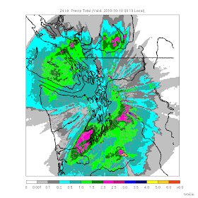
Here is the latest 24-h rainfall map from Seattle Rainwatch. Heavy rains continued last night and the focus was in a band stretching from the SW side of the Olympics through south Seattle into the foothills. A number of locations have received 2-3 inches with 3-5 inches on the western slopes of the Cascades. During the last 24-h (ending 8 am) Shelton has had 3.8 inches, Quinault 5.35 and the NWS has a flood warning out for the Skokomish River.
But things are about to change....the latest radar shows the wet front band is about to move through central Puget Sound
 and the latest visible satellite image shows not only the frontal band...but clear skies behind (see images).
  Unfortunately, improvement will be slow for central Puget Sound where a convergence zone will set up today. Here is the forecast precipitation ending 11 AM:
and the forecast cloud cover at 2 PM:

So if you want bright sun today and you are in western WA..you can have it...just get out of the convergence zone. That is what I am going to do!
That Skokomish river is kinda unique. Its always the shot for the salmon swimming across a country road.
ReplyDeleteBut that river rises and lowers so much more quickly than other rivers. Its drainage area must be steep and very rocky. I dunno.
Mostly Sunny and upper 80's in Gilroy Ca. Sigh!
ReplyDeleteVery impressive PSCZ rain band over Capitol Hill, Seattle on Sunday night with one lightning flash with thunder at 2248. That seems to be associated with a little cell moving west to east on the Rainwatch radar rendering embedded in the other rain.
ReplyDeleteThese orangish cells(?) seems to reappear drifting across Lake Washington and then drift to south of Kirkland and north of 520. I presume a small warmer humid air is getting lifted a bit with the CZ and then the lift keeps going given the colder air aloft. Classic thunderstorm on a "Seattle" scale.
Persistent moderate rain for the following hour.
Smokejumper,
ReplyDeleteThat pesky Skokomish floods so easily because land use actions have exacerbated some natural rain patterns.
The entire south fork basin has been clearcut which means a rapid runoff and large sediment load. The north fork has been damned which you would think would reduce flooding. However, the loss of that water means the sediment doesn't get washed out to sea, but instead is silting up the main stem of the river, cause easy flooding.
Interesting history:
http://www.getlostmagazine.com/features/1999/9906skok/skok.html
http://uwnews.org/article.asp?articleid=3438
http://en.wikipedia.org/wiki/Skokomish_River