But it looks like this is going to change, with the mountains beginning to build the wintertime base of snow that all skiers long for.
The first shot comes on Thursday, when a very deep trough moves over the West Coast, pushing the jet stream into California. Take a look at this 500 mb upper level chart at 2 PM on Thursday (below)...quite a deep trough over the northwest...and lots of rain and weather going into southern CA and the Southwest. Bad time in lotus land! And a huge ridge in the eastern Pacific....reminiscent of a La Nina-type pattern.
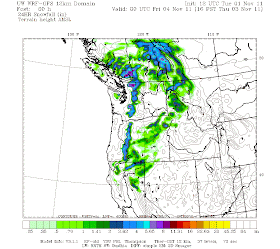
Here is the snowfall for the 24-h period ending 5 PM on Thursday--several inches in the Cascades--with some of it getting down to pass level (snow level descends to roughly 2500 ft). Not much, but a start.
Then another trough moves in on Saturday, and again the bulk of the flow going into California.
This relatively weak feature only provides a dusting of snow over the Cascades, perhaps and inch or two at the most.
But then on Monday another trough approaches--stronger and embedded in much stronger flow. This system could produce FAR heavier snowfall, with totals reaching a foot or more.
Of course, our confidence in the forecast declines in time, but it is clear that during the next week, a colder, wetter pattern more reminiscent of the La Nina situation of last year will set up. In fact, the NWS Climate Prediction Center forecasts for the next 6-10 days is for colder than normal and wetter than normal conditions (see graphics)---enough to warm the hearts of Northwest skiers hoping for an early start to the season. And yes...a reminder of last year.
KUOW Update
I have been fairly quiet about KUOW recently, not the least because I am really enjoying doing my weekly weather program on KPLU (Fridays at 9 AM) with Keith Seinfeld, their excellent science reporter. But all too often I get reminded about the attitudes over at KUOW, and particularly at Weekday, that I found so disturbing when I was on the inside. Case in point: Joel Connelly, the well-known PI reporter. This week Joel wrote the following:
"Not long ago, on KUOW Radio -- before being exiled for protesting their ouster of weather expert Cliff Mass..."
Joel was one of the wisest and principled voices on the 10 AM "Week in Review" Friday program on KUOW, and a wonderful counterweight to the very conservative views of the Seattle Times' Joni Balter. He was a vocal critic of my "firing" for the terrible sin of talking about an education issue on one program--and wrote a very supportive piece in the PI on the subject. Turns out that criticism of Weekday staff or KUOW management is not allowed by this public radio station. It appears that by speaking his mind, Joel was given the boot....in a very similar way I was given the boot when I disagreed privately with Steve Scher's approach of selectively allowing certain opinions on his show. Folks--this is very disappointing behavior and quite frankly unacceptable for those responsible for a very important public radio outlet--a station whose license is held by the University of Washington.
And as long as I am complaining, why does KUOW Weekday insist on using a non-meteorologist, posing as a meteorologist, on many of their Friday shows? This is about as reasonable as having a person without a medical degree doing surgery or providing detailed medical advice. And what does this say about journalistic integrity? The KUOW audience deserves better.
Local American Meteorological Society Meeting on Friday: Open to All
The Puget Sound Chapter of the American Meteorological Society will be meeting on Wednesday, November 2 at the Northeast Branch of the Seattle Public Library at 6:30 PM. UW Graduate Student Luke Madaus will describe the new dual-polarization products available from the newly upgraded National Weather Service radars. All welcome. Location: 6801 35th Ave. N.E. More directions at: http://www.spl.org/locations/northeast-branch/net-getting-to-the-branch


KUO Who? I haven't tuned into that station since you left, and frankly can't imagine why I would. My listening time and my pledge dollars go to KPLU, with a little extra during the last pledge drive to thank them for getting you on board.
ReplyDeleteHi Cliff. I was wondering about the low temp forecasts on probcast.com. It appears to be forecasting higher lows than the actual temps I observe at my location west of Mount Vernon. I believe I recall you mentioning awhile back that there was a glitch with the low temp forecast. Is the confidence level high in that aspect of probcast? Thanks.
ReplyDeleteWe've dropped our KUOW membership, and let them know why. We're supporting KPTZ here in Port Townsend.
ReplyDeleteThis comment is not on topic, but I was hoping a future blog post could discuss any west coast implications now that reactor no 2 is in meltdown at Fukushima. Thanks and love your work.
ReplyDeleteCalling Joni Balter "very conservative" is hyperbole, right?
ReplyDeleteGoodness gracious, Cliff, you're pretty far to the left. Nobody at the paper is "very conservative". Time to get out of academia for a bit! ;)
ReplyDeleteEnjoying your comments regarding mountain snow. I had a question about how you got that model result- I've been using the model for a while and don't see a 184h in the public link- is that something that is kept behind the scenes? I'd love to see what the models do at longer times....and specifically see how the 'forecast' for this mountain snow might be changing.
ReplyDelete