Yesterday (Saturday) the area experienced an event more common to the eastern U.S.: a summer convective squall.
Forced by an short-wave trough aloft that was moving northward, the action occurred around noon to 3 PM, as the fast moving line of convection brought heavy rain, lightning/thunder to some, and winds gusting up to around 40 mph on the east side of Puget Sound. Roughly 10,000 customers lost power, including 6,000 customers in Mukilteo, Monroe and Granite Falls served by Snohomish County PUD and a number of trees were downed including one on I5 (see picture above). The raindrops was far bigger than normal, a sign of the convective origin of the rain...and the top of the thunderstorms exceeded 25,000 ft...very high for western WA but wimpy back east.
The Granite Falls area got hit particularly hard. Here is a very professional video on the storm by Mark Horner (click on image to view)
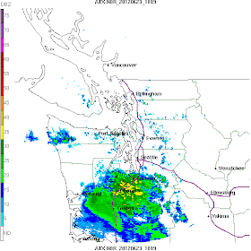
Here is the radar sequence, and keep in mind the red indicates POURING rain or hail.
At 11:19 AM...showers were south of Seattle and moving north. Some yellows (moderate rain)
At 12:09 PM, the squall line was evident...see the line of red colors. My gutters were overflowing at that time! The line was more intense east of Puget Sound.
At 1:21 PM, the squall line had moved north of Everett, with moderate precipitation behind.
At 2:35 PM it was the turn of Bellingham and vicinity, while the rain was over in Seattle.
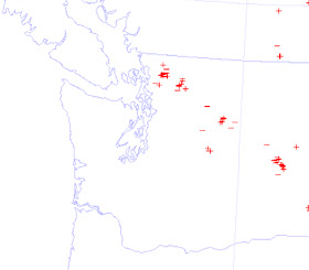
This band extended across the Cascades into eastern Washington. You can see that by following a sequence of images showing the lightning at 11:30 AM, 1 PM, AND 3 PM. The lightning was pretty much limited to the eastern portion of western WA, the Cascades, and eastern WA.
Here is what happened when the line passed the UW (where it was only of moderate strength). Winds gusted to 25 knots (around 30 mph), precipitation picked up, temperature fell from the low 60s to the low 50s, and pressure abruptly increased and then steadily rose after that.
Although the forecast was for showers yesterday, the strength and timing of this particular feature was not well forecast...which is not surprising. Here is the UW model precipitation forecasts for Saturday (staring 5 AM Saturday morning)--it thought a fairly strong line would occurred...but the timing was hours too late.


I was in Chelan on Saturday,and we saw the brief effect of that storm system, as the wind picked up around 3:00 and was blowing quite strongly for about 20 minutes. It threatened rain but we were spared, and then it all cleared away.
ReplyDeleteThank goodness that I am a good backyard farmer. My corn is still standing, albeit, a bit bent over.
ReplyDeleteGood post Cliff during this interesting period. Its not extreme weather by any means but for this time of year!?!
ReplyDeleteAnyway, even under dynamic SE flow and low pressure to our SW. Usually a great moisture feed on the leeward slopes of the Cascades, we've been spared. Steady west gap winds last 3, 4 days. Strong temperature/pressure gradiant.
Also, that Columbia River Gorge is a homicidal thunderstorm killer. Ill always watch t storms in central OR race north and if theres a thru west wind, they're finished. Farther east, there's been some borderline supercells this week. Very cool.
Saw your post on Saturday about getting out before the rain, checked the radar map and tried to coax the wife to hurry a go walk the dog with me. We were about 15 minutes too slow and got caught in the downpour! Total soaking to the point of Hollywood movie hilarity. Maybe next time I'll bring my rain coat.
ReplyDeleteI was caught in this while on a hike to Mason Lake in the Alpine Lakes Wilderness. Received some small hail mixed in with heavy rain and numerous lightning strikes nearby.
ReplyDeleteFrom the Mill Crrek area, the squall was interesting but not spectacular. about 15 minutes of rain, some wind, not much lightning...
ReplyDeleteI wonder if this explains the shot we got at 4PM on Saturday up here in Port Alberni on Van Isle. We had a good downpour that peaked at 16mm/hr at 16:06 along with steady 40km/h wind which probably led to an underreported rain rate. It was really coming down.
ReplyDeleteThe Kendall WA area east of Bham - it was like a small twister. Tree top came crashing down and running water eroded our dirt road. A big event here
ReplyDeleteA bit off-topic, but curious what you think of this iOS app that purports to accurately predict upcoming weather events (http://bit.ly/LO6kms) and if you think it's a good choice for working with unruly PNW weather?
ReplyDeleteThe Federal Way Farmers Market was going on during this downpour. Most vendors had to leave. I sure hope this weekend is much better!
ReplyDeleteAre we going to have summer this year? Could you please do a post on summer 2012? Please? Pretty please?
ReplyDeleteSummer starts after 4th of July .. if I recall correctly Cliff has noted previously that our warm weather starts around July 7-11, statistically.
ReplyDelete