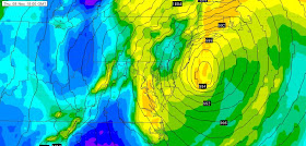
Let me be clear, this storm will not be as intense a storm as Sandy and will not be a hurricane. Rather, it will be an extratropical storm driven by horizontal temperature variations. But it will be capable of producing strong (40-50 kt) winds and flow that can push water inland over vulnerable areas. It will me a major storm.
Lets turn first to European Center model, which did so well during Sandy, and which generally has superior verification to the U.S. GFS. Each of these forecast maps show sea level pressure (in hPa or mb) and relative humidity near the surface (2m). At 10 PM PST Wednesday, we find a strong low off of Maryland, with very strong pressure differences (gradient) along the coast. There would be powerful easterly onshore winds across coastal NJ and in LI Sound with this pattern. Central pressure perhaps 978 hPa.
The low is unfortunately slow moving. Twelve hours later (10 PST), the low was off New Jersey, with a central pressure a bit less than 984 hPA. (Remember Sandy was 946 hPa at landfall!).
7PM Thursday the low is just SE of the east end of Long Island.
What about winds? Here are the predictions for near-surface winds at 7 PM Wednesday. Some sustained winds reaching 50 kts, with higher gusts. This is serious stuff. Strong enough to down trees and capable of creating a modest storm surge.
What about the U.S. GFS model? Here is the forecast for Wednesday at 10 AM from the model run started at 5 AM Saturday. Deep low a bit more offshore and faster to move northward than the European model.
And the windfield is also threatening.
This is a major shift for the U.S. GFS model, which had the low way offshore yesterday:
 | |
| GFS forecast started 18z Nov 2, 147 hrs (valid Thursday, 1 PM PST) |
As I have noted many times in the past, one should not look only at the high-resolution forecasts, but should study the ensembles to evaluate the uncertainty in the forecast. This figure shows the high resolution European forecast at 4 AM PST Thursday on the right and the MEAN (or average) of the ensembles (many forecasts at somewhat lesser resolution) on the left (both blue lines). The shading in both is a measure of uncertainty. The ensemble mean has a low center that is broader and centered a bit offshore of the high-res prediction. The shows there is some uncertainty in the position and intensity of the low, but clearly most of the ensemble are going for a coastal cyclone.
The ensemble of the GFS models runs, show below (starting and ending at exactly the same times), is very different, with ensemble mean off of New England, with lots of uncertainty to the west.
So, the bottom line is that both the deterministic and ensemble prediction systems of the U.S. NCEP model center and the European Center are now forecast a strong cyclone over the NE U.S.. The potential for strong winds are considerable. With cool air inland, there is a good chance for major snow away from the coast. The European Center model had been calling for this solution for day, while the GFS model, initially taking the low center offshore, is now producing a forecast more similar to the European model.
The issue of the relative skill of the U.S. and European models has garnered a lot of media attention this week, and I will return to this critical subject in a future blog. As a sample, here is a graphic on the NBC nightly news on Friday night (white is the actual path).
.........................................................
I will be giving a talk: Global Warming Over the Pacific Northwest, Separating Facts from Hype, at the Mountaineers in Seattle at 7 PM on Thursday at the Mountaineer's facility in Seattle (Magnuson Park). Open to the public ($5 contribution for non-members). For more information, go here. Will talk about Sandy's implications as well.


Each model run this thing looks nastier. Going to be a tough time in the NE.
ReplyDeleteI am wondering why the European weather model is so much better than the US model and why we don't adopt that technology?
ReplyDeleteIt's like you're reading my mind here, Cliff. I'm on the East Coast on business and I'm going to be driving between Boston and Philadelphia on Wednesday night, staying in New Jersey Wednesday - Friday nights. I've been curious about this storm since I first heard about its potential formation. Thank you for keeping us up to date on this! It could really affect my plans. Think I'll put together an impromptu emergency kit...
ReplyDeleteI am still not understanding the generation of the surge which seemed to have the effect of a tsunami and caused most of the damage (the NOAA maps for precipitation at leave over NYC showed minimal rain). Wiki says something about water "piling up" on itself...and the record low pressure. Why? And was that the real driver of destruction?
ReplyDeleteI won't be able to make your talk Cliff, but I wish I could. The most important thing in this "debate" our country is having about global warming right now is that the facts are separated from the hype. All this hype is threatening to overwhelm any real discussion about global warming. And the facts are getting lost in it. In the hype. So good work.
ReplyDeleteYou should see if the nytimes will accept an op-ed on the model quality gap.
ReplyDelete