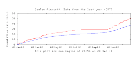
Seattle has had around 48.5 inches of rain so far this year, about 12 inches above normal. To get a view of how we got so wet, here is a plot of the normal cumulative rain (blue) versus what has actually hit the airport (red). Two wet periods stand out: late winter/early spring and this fall (after roughly 20 October). And, of course there was our dry spell during the late summer/early fall.
Do we have a chance of any records? The greatest annual rainfall at Sea-Tac was 55.14 inches in 1950. There is little chance we can reach that in a few days. Only three years (including 1950) got above fifty inches...there is a good chance we will get close to that level. In any case, we will "enjoy" living in one of the top 10 wettest years since 1948.
But the pattern is a changing.... the latest NWS Climate Prediction Center 6-10 day forecasts show drier than normal conditions over the Pacific Northwest. The origin? Persistent ridging (high pressure) over the region with a few glancing blows, mainly to our north.
The European Center Model has very little precipitation over the lowlands during the next week, and even the U.S. GFS model takes most of it to the north and south of us. This weekend looks fine, with only a few showers around. No serious weather.
The snowpack is not only bountiful, but it is unusually good condition, since we have not had many warm rain periods to turn it into Cascade concrete. Very few wet/warm atmospheric rivers this year. As shown below, much of the region has 150% or more of normal snow water equivalent (amount of water in the snow).
So the skiing is very good.
Talking about skiing, today was the last mountain/avalanche forecast of a mainstay of the local mountain weather community, Mark Moore. Mark has been the leader of the NW Weather and Avalanche Center for years, and his work has not only immeasurably strengthened this crucial local resource, but has undoubtedly saved many lives. We owe him a real debt and wish him the best. By the way, the NW Avalanche Center deserves your support, particularly if you depend on their mountain weather and avalanche forecasts. The latest Seattle Times/NY Times articles on the Tunnel Creek avalanche deaths shows how important the NWAC is and why you should listen to their warnings!
 |
| Mark Moore, Director of the NWAC |


Bellingham has missed out on the extra precipitation this November and especially December.
ReplyDeleteWhile Seattle has 7.31 inches to date this December, Bellingham has only 1.67, a difference of 4.4 fold. This is compared to averages in December to this date of 4.82 in Seattle and 4.02 in Bellingham, not such a large difference. Vancouver has 5.19 to this December date so it also far ahead of Bellingham.
Mt Baker Ski Area has done well so the heavy overcast has certainly been in Bellingham, but somehow not the heavy rainfalls.
Alan Fritzberg
Bellingham, WA
Are those B'ham numbers from the airport, or...? They definitely aren't reflective of north Whatcom County. I find it difficult to believe that Bellingham has had one-third to one-fourth the rainfall we've just up the road.
ReplyDeleteThe numbers for Bellingham came from the airport (via Weather Underground monthly data) and the Bellingham Herald which this morning showed the same cumulative number for December.
ReplyDeletevery interesting and informative article about an avalance near Stevens Pass
ReplyDeletehttp://www.nytimes.com/projects/2012/snow-fall/#/?part=tunnel-creek
I've recorded EVEVEN point NINE inches of rain so far this month at my home on the Bothell - Mill Creek line.
ReplyDelete