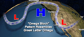
This pattern tends to be self-reinforcing and can be stable for days. The current model forecasts shows this pattern setting up on Friday and lasting for quite a while. Let's take a look at the upper level (500 hPa, about 18000 ft) for several times, starting with the forecast for 10 PM on Friday. The upper ridge has begun to push northward over the eastern Pacific.
Twenty four hours later (Saturday at 10 PM) the ridge and the block have intensified. No precipitation in this pattern!
Or Sunday night:
Monday night, still there:
and even late Tuesday, it is holding on!
You get the picture...an example of an amazing persistent blocking pattern. No precipitation over the West Coast, and yes the threat of persistent low clouds and fog over interior valleys (including Puget Sound and the Willamette valley)
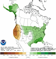
Based on this pattern, the National Weather Service's Climate Prediction Center is going for below normal precipitation over both the 6-10 day (left image), and 8-14 day (right image) periods. We get stuck in a dry situation, the eastern U.S. in a wet one.
It is good we have a decent snow pack right now....there will be little additional
accumulation starting Friday.
We are now running out of the time for
real winter weather. Generally, it is rare to get major windstorms,
precipitation events (atmospheric rivers), snow, or anything else after
the third week of February around here. We know nothing is in store for the first
two weeks of the month. Not much time after that.
Finally, the meteorological honor of Seattle citizens is at stake. Atlantic Monthly has called us "weather wussies" because we are sensitive to a little snow. Let them check out our hills or the ice that tends to develop after light snow. Consider that East Coast types, such as the Atlantic editorial staff, give names like "Storm of the Century" and "Perfect Storm" to events that would invoke a tepid shrug from a Northwesterner. We know who the real weather wimps are.


I should have taken a picture of one of our intrepid downtown bicyclists stopped at Boren and Pike on one of those light snow days! Contemplating whether or not to continue down hill...no wussies here!
ReplyDeleteI was wondering when we were going to give up and call it a lame winter. With the 10 day forecast, I guess now's the time. I just hope our winter doesn't decide to give it a try in the spring. :(
ReplyDeleteI agree with C.P.O., I'd rather have the winter now than in April through June. How's the spring look?
ReplyDeleteBTW, I hope this next high gives us the sun and not another big inversion. Do you think the sun is high enough to heat and mix? Seems like it usually does in February.
Ansel
Cliff, what you call "lame" I call "lovely", quite frankly. Time to get to the p-patch and plant 2013's bumper crop of peas!! :-) P.S. Lake Huron and Lake Ontario are at record-low levels. The midwest NEEDS all that rain. Let 'em have it!
ReplyDeleteJust read this:
ReplyDeletehttp://www.guardian.co.uk/world/shortcuts/2013/feb/06/thundersnow-what-causes-it
"Thundersnow" seems to be a fairly common phenomenon around here; seems about half the time I've seen & heard lightning & thunder. it's accompanied with snow. Care to elucidate?- seems like it would make an interesting blog post. Don't think I ever experienced this in years of living in the Midwest.
Man, what a horrible winter season for the lowlands. BORING! Only if that high would station a little west in the middle of the Pacific so the stream could come down and we could get some arctic air. Anyway, I will be keeping an eye on the Boston Blizzard since our weather is zzzzzzzz.
ReplyDelete"Turning into"? You must live closer to Alaska and the North Pole than I do, or something... Portland's winter was lame before it even began. In my neighborhood, we've been waiting over 4 years now for accumulating snow. Sadly, my neighbor's six year old doesn't even know what snow is (too young to remember December 2008), and I fear he'll be too old to enjoy it the by the time sled-able/snowman-able snow comes back around. Imagine, going your entire childhood living in NW Oregon without ever getting snow in your yard?! Mayhaps poor driving habits and inflated real estate prices aren't the only things Californians have brought up here with them??? :(
ReplyDeleteMissing winter? Go check out Boston's forecast... Boston Herald: Blizzard Watch: Friday Travel Could Be Nearly Impossible
ReplyDeleteI'd rather be here in the benign drizzle. :-)
I have relatives in Rhode Island. Wondering how high the snow drifts might get?
DeleteBlocking ridges seem so frequent in February it would be interesting to see if this phenomena is reflected in the weather statistics for the month.
ReplyDeleteI'm hoping for some springlike temperatures this month as a stronger sun breaks through the temperature inversion.
Seems like we've been under a ridge since Christmas.
ReplyDeleteWell, up in the islands we had a significant, and not forecasted, wind storm last night. All the TV pundits were saying "breezy" in the islands, winds 15-25 or 20-30, NWS forecast max gusts of 32 for our location.
ReplyDeleteOops. Out on the west side of the islands (Haro Strait buoy) sustained winds around midnight hit 43, gust 53. Gusts from about 8:30 on were almost constantly in the 40s, and we lost at least one tree (over the drive, haven't checked in the woods yet).
Yet no wind advisories from NWS.
What happened? Why did they miss this one so badly?
People who live in Portland or Seattle and complain about no snow have only to get into their cars and head up into the mountains, where there is more than enough snow for everyone. (and where it belongs afaic....)
ReplyDeleteThe main and broader heat distribution at the 900mb height-level, illustrative of the pattern's having begun to set up.
ReplyDeletehttp://discover.itsc.uah.edu/amsutemps/AAT_Browse.php?chan=04&satnum=15&aord=a
Richard 583,
DeleteIf you have the time perhaps you could send me this link and further explanation regarding the formation of this "Omega Block" high pressure ridge. I think this is a great opportunity to increase my atmospheric / meteorological knowledge. Thanks... gpacharlie@gmail.com
Just curious. The value (X) hPA is used routinely in graphs and discussions. I know you have stated it is a measure of pressure. I have also seen mB as a unit of pressure when describing lows, especially hurricanes and strong northwest windstorms. Here you use about 18,000 feet and 500 hPa interchangeably or synonymously or directly proportional? Maybe it is too much detail for this blog but I am curious how "deep" the Omega Block boundaries are in feet ( for example what is happening at 180000 feet vs. Say 1000 feet, and can high clouds go over the block and low clouds float under the block. Also curious how 'wide' is the jet stream at any given altitude or hPa?
ReplyDeleteHello Cliff,You may have already mentioned this at some point already but are you familiar with the PING Project?
ReplyDeletehttp://www.nssl.noaa.gov/projects/ping/display/
Thanks for all that you do
Gary
Calico Jack of Dabob Bay
Oops ! One too many zeroes. 18,000 '
ReplyDelete