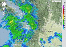
Today has been one of amazing contrasts. A river of moisture (a.k.a. the finger of Poseidon) has been approaching the Olympics and North Cascades, producing very heavy precipitation, while in the rainshadow of the Olympics it is has been nearly dry. We are talking about a hundred-fold variation in rainfall over a few dozen miles. The multi-radar image at 9:14 PM Tuesday shows the contrast vividly.
Let me further illustrate by starting with the storm-total rainfall at of 9 PM Tuesday from the coastal (Langley Hill) and the Camano Island radar. First, consider the Camano Island radar (remember it does a poor job over the Olympics). You will notice the central and northern Cascades are getting hammered with peak values of roughly 5 inches. In contrast, nearly nothing fell from Seattle across the Kitsap, with heavier values towards the north Olympics and Strait (5 inches plus).
The Langley Hill radar (see below) shows at least 5 inches on the western side of the Olympics and a substantial decline over the ocean.
We can also look at the rainfall measured at the ground. Here are the values for the 24-h period ending 9 PM Tuesday. In central Puget Sound many locations had only .01-.04 inches--barely enough to wet the concrete. And yes, those dessicated folks in Sequim had only .01 inches. In contrast, lots of locations on the western and southwestern side of the Olympics and in the north Cascades had 3-4 inches. Extraordinarily short distances (say from Bothel, just north of Seattle, to the nearby foothills (roughly 20 miles to the east) brought a change from a few hundredths to well over three inches. Amazing. This is why one has to love Northwest weather...the contrasts are extreme.
Just as amazing is that our numerical models had a pretty good handle on the situation. Here is the 24-h precipitation prediction starting 4 PM yesterday (a close match-up in time for the plot above). Not perfect, but it realistically predicted the rainshadow and heavier precipitation in the Olympics, mountains of Vancouver Island, and the central/north Cascades.
Based on this forecast, I biked to work on Tuesday. Piece of cake.


So did I.
ReplyDeleteOf course it held off raining until I left for home, but so it goes.
I'll take it. I was anticipating a deluge.
I've been sort of underwhelmed here on Cap Hill. I was expecting rain in biblical proportions, but so far it's been extremely meh.
ReplyDeleteWow your blog is great. I realize how little I know about our little blue ball spinning in space.
ReplyDeleteThis isn't related to the post, but I am a regular reader and am curious what you think about this report.
ReplyDeletehttp://www.accuweather.com/en/weather-blogs/climatechange/projected-changes-in-snowfall/7030230
Shows parts of the Northwest getting anywhere between 40 - 100% less snowfall over the next 70 years.
I got soaked both afternoons riding home on my bike in Vancouver BC. It was fine in the morning. At least I can change pants when I get home. In the morning it was fine. The weather changes so fast.
ReplyDeleteUnrelated but sometimes I'm amazed how models today can do such an about face with such a short period time. Given it was days away, but potentially the storm of the year completely disappeared in tonight's GFS run. And my beloved euro, which latched onto the idea a couple nights ago, went from a massive cold trough to a massive warm ridge within today's run. I'm thinking about ending my affair with the European, maybe the NAM will have me.
ReplyDelete