The past several days has brought strong showers, lightning, and occasional gusty winds. But that inclement weather will soon be a memory as a major ridge develops over the western U.S. Temperatures will climb into the 80s west of the Cascades, with highs reaching into the lower 100's early next week over portions of eastern Washington.
The latest 6-10 day temperature forecast from the Climate Prediction Center says it all: well above normal in the west, with the most anomalous warmth (dark red) over eastern Washington and Oregon.
The origin of both our current cool/wet pattern and this weekend's warmth is essentially the same: a perturbed upper level flow pattern. Let me explain. The upper level (500 hPa) flow pattern today (at 2 PM, see below) had a VERY deep low over the eastern Pacific and a ridge of high pressure over the Rockies and western Plains. This left the Northwest in strong, moist southwesterly flow that brought the showers and clouds (remember the winds are parallel to the height lines and strong winds are associated with large gradients in heights--closer packing of the lines).
By Friday afternoon, both the low center and the ridge move westward, and the ridge builds in amplitude. Expect substantial improvement.
By Monday the flow pattern is really perturbed and "high amplitude" as we call it in the weather biz. The ridge will then be just west of the Rockies and the flow over the northwest will be weak and from the south. A warm pattern for the region.
This strange upper atmospheric pattern continues into Tuesday. The building of high pressure over our region is associated with clear skies, little precipitation, and warming. This particular pattern will bring the highest temperatures east of the Cascade crest (to get record warmth over western WA the ridge would have had to be centered farther westward).
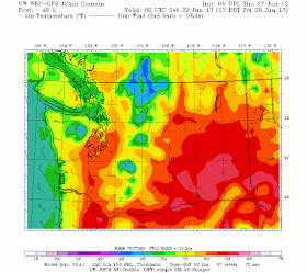
The UW WRF model is going for a nice warm up by Friday (see graphic), with temperatures reaching into the low-80s over SW Washington and low 90s in eastern Washington.
Sunday at 5 PM, a bit warmer in eastern Washington.
But then on Monday, western Washington and Oregon, start ramping up, with highs up into the 80s in western Washington, 90s into the Willamette Valley and around 100F in the warmer portions of eastern WA.
And Tuesday will probably be even warmer...enjoy.


Looking at the extended GFS, sure looks like a lot of CAPE around N. California up thru W. Oregon. I wonder if we're going to have a little light show after the heat wave. I know it's too far out to get hopes up though but a storm spotter can hope. :-)
ReplyDeleteMy concern is we will have a major marine push on the 4th or a trough come in as this seems to be a cycle around here after a big heat up like that. Sadly, it would be right on the 4th making for a very dreary, cool and possible wet day. Horrible timing in my opinion!! :(
ReplyDeleteWe're also going to have a lot of HUMIDITY during this heat wave due to 1) all the rain we just had both sides of the Cascades, and 2) little to no east wind to dry out the lower atmosphere.
ReplyDeleteIs it just me, or does anyone else think it's odd that these "strange" and "unusual" gigantic upper-level ridges in the eastern Pacific are in fact becoming 'usual'? Evidence of increasing global climate change/chaos?
ReplyDeleteThose were two good points left above. The WRF-GFS continue to put CAPE values in the 2000 to 3000 range for parts of the PNW. That's unusual. Wonder if its overestimating something like dew point etc....
ReplyDeleteBut if you look at the column integrated water vapor, there's a lot of residual moisture sticking around with maybe an influx off south of Cali.. Maybe hot and humid. Again unusual relatively speaking.
Heard there will be a lack of tstorms due to a strong CAP? So there's cape and cap. It'd be awesome if you could explain more about our scenario.
CAPE ( convective available potential energy ) and Cap ( a lid on the upper levels ) @ 700mb the air will be very warm and limiting the potential for lift, unless decent forcing can occur thus compensating for the inability to break through the very warm layer up above. Think of the cap like a lid on a pot, the steam rises in the pot but the lid prevents the steam from rising beyond the lid and the same principle is at play here.
ReplyDeleteWe need good forcing for any storms ( likely high based ) to bust through that cap.
Basic explanation and I'm sure professor Mass will go more in-depth on this.