So far tonight I have gotten nearly a dozen emails with pictures of "strange triangular clouds" and a request to explain them. Let's see what I can do.
Here are some samples, the first sent by Eric Berman and the second by Jacob Bruce. Pretty amazing pictures.
This a line of cirrus clouds that were precipitating ice crystals. These appendages with falling ice crystals are known as fall streaks or mare's tails.
To get a better perspective, here is a close up view of a NOAA weather satellite image at 7 PM. You can see a line of clouds stretching east-west. That is what folks were viewing.
It turns out that the line was there for hours and extended out over the ocean earlier. Not chemtrails or aliens.
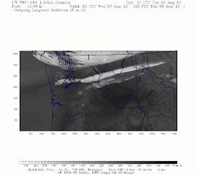
The high-resolution WRF model run at the UW had put a cloud line across the region at about the same time. To illustrate, here is a 15h forecast from the 4/3 km domain for 8 PM that is simulating what a infrared satellite would see. Not perfect, but the model wants to create a thin line of cloud across the region.
But why? Here is are the simulated winds at 300 hPa (around 30000 ft) from the same model (again for 8 PM). There is a big change in wind direction in that area from northwesterly winds on the north side and easterly winds to the south, a situation that can produce an areas of rising motion at the interface.
Looking at the UW weathercam, it does appear that these features developed in jet contrails.
A picture immediately before the clouds developed, did show some features that looked like contrails aloft. These are oriented north-south.
Then a cloud line developed and did look like a contrail. But unlike typical contrails, small cumuloform elements started to form
The elements were maintained and increased in size.
A second line then developed (again another contrail), with similar small cumulus development.
Then this line started to precipitate ice crystals, giving the structure than many of you noted.
So we had an area aloft that was near saturation and the moisture from the jet engines pushed it over to saturation...giving a contrail. The atmosphere aloft was close enough to instability that small cirrocumulus elements developed and subsequently precipitated.
On the meteorological Richter scale this might be a 1, but it is an interesting diversion on the beautiful summer night.
Photo sent by Linda Thomas


Unique and wonderful. Thanks to the curious readers who sent you the pics and thanks for the explanation!
ReplyDeleteAny thoughts on the regular spacing of the clouds in the formation?
ReplyDeleteI was just going to send you yet another picture of the same thing that I shot in Bothell last night around 7:00 PM. The line of clouds was striking, and went for miles from what I could see -- and I couldn't see the end of it. Thanks for the explanation.
ReplyDeleteThe UW Atmo Sci webcams caught these clouds forming and evolving quite nicely:
ReplyDeletehttp://www.atmos.washington.edu/images/webcam2/movies/20130806.mov
http://www.atmos.washington.edu/images/webcam0/movies/20130806.mov
Towards the end of the day; boring blue otherwise...
I would be surprised to see two parallel E-W contrails over Seattle form that close in time to each other. Almost all the air traffic above Seattle at cruising altitude follows roughly NNW-SSE paths (SFO, PDX or LAX to Japan, Korea). Occasionally we get traffic from, say, Houston or Denver passing over us on the way to East Asia, but never that quickly in succession, nor so parallel. I think the formation was purely meterological in origin.
ReplyDeleteDid anyone confirm that there actually were jets? I couldn't see any in the video and wonder if Michael Lakeman's hypothesis has weight. Could these simply be Kelvin-Helmholtz waves created from a wind velocity shear? Also, another tidbit, I did see a rainbow towards the end of the show in one of the lower level clouds. Would this be the Circumhorizontal arc phenomenon? Thank you so much for this rich scientific explanation, I have been fascinated and learning about clouds ever since I spotted this last night!
ReplyDeleteI doubt these originated contrails. I think the original vorticity explanation is more likely.
ReplyDeleteWest-east flights at that altitude are rare here; a review of commercial flights at that time shows no W-E activity (http://www.flightradar24.com/2013-08-06/23:30/12x/47.31,-122.29/9) though it always could have been military. FWIW, the N-S contrails preceding the show look like WJA1698 YVR>SLC and ACA554 YVR>LAX.
Not really on topic to this post, but I was surprised to learn (KUOW via national NPR)
ReplyDelete“The Pacific Northwest has lost about 50% of its snowpack over the last 50 years."
http://earthfix.kuow.org/flora-and-fauna/article/tracking-an-alpine-frog-that-chuckles-and-beeps-fo/
Interesting story on the frogs, and no doubt they are in peril owing to a variety of factors, but this 50% figure, where did that come from?
Thanks for the explanation and time-sequence photos. And especially thanks for pointing out that they are not chemtrails !
ReplyDelete“The Pacific Northwest has lost about 50% of its snowpack over the last 50 years."
ReplyDeleteApparently since KUOW booted Prof Mass, they don't feel the need to be honest any more...
http://cliffmass.blogspot.com/search?q=snowpack+loss
According to the international cloud classification, the cloud forms are Cirrus spissatus.
ReplyDelete