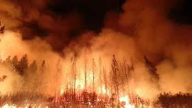
The fire and smoke plumes are highly buoyant and extend miles high into the troposphere and are even apparent on local weather radars. This image form Monday evening shows the boundary of the fire and you can see the radar returns over the highly active eastern and southeastern sides of the fire.
A high-resolution NASA MODIS satellite image for Sunday shows the plume of smoke moving northward into eastern Oregon and southeast Washington and then eastward into Idaho and Montana.
This plume just does not contain particles but is full of other combustion products such as carbon monoxide. Here is model-diagnosed carbon monoxide in a vertical column of air produced by biomass burning (like burning trees) for Sunday morning calculated using the GEOS-5 air chemistry simulation system (thanks to Professor Lyatt Jaegle for pointing this out to me). The carbon monoxide from the Sierra fires moves northward into the Pacific Northwest and Alberta and then heads east. Amazingly, the stuff spreads all over eastern Canada and the U.S.,
Here is the same graphics for this morning: pretty much the same story.
Pilots near Reno report the visible smoke is topping out around 12,000 ft., but it surely ascends more to the north and east.
The reason the smoke/pollution is taking a large loop is due to the upper air pattern: here is what is looked like this morning at around 18,000 ft. You can see a high pressure area over the central U.S., with the winds circling clockwise around it (wind are generally parallel to the solid lines).
The weather situation will not change much the next few days over the Yosemite area...not good news for the firefighters there.


Cliff: Any insights on the state of this summer for California? Was it particularly hot or dry?
ReplyDeleteThanks, Don
Writing from Sonora, within miles of Rim FIre.
ReplyDeleteFlew in jet from NYC Weds 8/27.
From New York, saw thin streams of black above 30,000 ft. cruising elevation. Assumed from RIM FIRE since was visible all the way to West Coast - same thin black strands at 30,000+
Can you explain why smoke carries at that elevation?
Your maps helped me understand, thank you.
Diane Magical 8/28/13