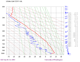
The skies have been full of contrails the last few days and today will be another one.
Here is a recent visible satellite photo...you see all the lines over southwest Washington?..those are contrails. Lots of contrails.
The reason for such a prolific display of contrails? The upper troposphere, where most jets fly, has been at or close to saturation. In other words, the relative humidity of that layer has been close to 100%, a condition indicated when the temperature and dew point are close. I can demonstrate this by showing you the vertical sounding this morning from the balloon-launched radiosonde at Quillayute, WA, on the NW coast (see below). The red is temperature and the blue dashed is dew point. The vertical coordinate is pressure. Jets often fly between 300 and 200 hPa (roughly 35,000 ft) and you will see the two lines are close together up there. Much of the moisture produced by combustion in the jet engines condenses rapidly in such an environment into droplets and freezes into ice crystals.
Below that layer the atmosphere is quite dry, with the sole exception of right at the surface. Look carefully again and you will see that near the surface the atmosphere warms with height through a thin layer...an inversion produced by active radiational cooling at the surface last night. A thin veneer of fog has formed at some locations, a veneer that will rapidly burn off later. Here is an extraordinary picture taken by the webcam on top of the UW atmospheric sciences building showing both features I talked about: the low clouds/fog burning off and lots of contrails aloft. Amazing image.
Sunday will feel like summer. According the the Seattle Profiler (mainly funded by the Puget Sound Clean Air Agency) temperatures are far warmer aloft (4-6F) today than yesterday and southeasterly flow is just above the surface (see graphic below, time increases to the left, temp (red lines) in C, height in meters). Such SE flow is generally very warm, as air sinks and warms on the western slopes of the Cascade Mountains. As a weather disturbance approaches our coast today, the offshore flow will strength.
Go outside and enjoy the warmth. It won't last...showers and clouds on Monday.
Update at 5 PM.
Well, the forecast max temps were a bit off...much of the area got into the 70s and some locations hit 80F. Here is the max temps as of 5 PM. Note how some of the warmest temperatures were in the foothhills (Enumclaw, North Bend), something we expect with offshore, downslope flow.
Bellingham Talk on October 15th
I will be giving a public talk on "The Future of Weather
Forecasting" in Bellingham on October 15th. In this talk, I will
discuss the development of weather prediction from folk sayings to
numerical weather prediction, and will describe what I think will happen over
the next decades. For more information, go here.


78.9 here in Eatonville, according to my home thermometer. According to the WeatherBug station, which is about a mile from my house, it is only 75. Either way, I'll take it! I was going into shock having such a quick transition from summer to fall! I do like my fall and winter weather....I just like it to come on a little more gradual!
ReplyDeleteIt got so warm and dry this afternoon that I knew it just had to be downslope flow at work. A very nice contrast to the previous weekend which I spent almost completely indoors due to all the rain.
ReplyDelete