Today, there were huge contrasts across the the state.
In the northern two-thirds of western Washington the clouds held in most of the day with temperatures only reaching about 50F---roughly 8F below normal (see satellite picture at 4 PM below to see cloud distribution). Many of you awoke to light drizzle-- a very bad sign, since drizzle is associated with deep stratus/stratocumulus that are difficult to burn off.
In contrast, the mountains and eastern Washington were glorious with bountiful sun and temperatures getting into the mid-60s.
Here are the max temperatures today. What a huge contrast! Highs in the 40s over Puget Sound and parts of NW Washington, while 70s occurred over the eastern slopes of the Cascades, portions of eastern Washington and over far southwest Washington. Nice in the Willamette Valley. So if you live near Puget Sound, sun is about an hour's drive away.
To illustrate the contrast, lets look at the temperatures during the last two weeks at Seattle-Tacoma Airport compared to the normal highs and lows. NOT ONE DAY HAS REACHED THE NORMAL HIGHS! Many days are 5-10 F cooler than normal.
But look at Yakima (see below) and you find a completely different story. Normal or above normal temperatures for many days and a high today of 75, roughly 25F warmer than in the west.
In a desperate, sun-deprived state, I head to the eastern slopes with some friends for mountain biking fun. It was around 47F in Seattle with some light drizzle. Miserable. As we started gaining altitude east of Issaquah we entered the bottom of the cloud deck and temperatures fell as low as 42F (due to evaporation of the cloud droplets). My friends were perhaps doubting my meteorological skills. But as we started climbing east of North Bend a miracle occurred, the skies cleared completely. Temperatures rose rapidly into the low to mid-50sas we approached the pass, and by the time we reached Cle Elum, the temperatures had warmed into the lower 60s. By mid-afternoon the eastern slopes were in the mid to upper 60s. Here is the view from a ridge above Roslyn, Washington around 3 PM. Heaven.
Returning to Seattle the wall of clouds was awaiting just east of North Bend. We were ready to turn around.
Picture taken by Roberta Spiro east of North Bend.
The amazing/depressing thing is that the models are forecasting the high pressure to hold in place for the rest of the week. So the stratus and low clouds are not going anywhere soon.
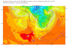
Here are the upper level (500 hPa heights) from the European Center mdoel for today at 5 AM, Wednesday, and Friday. The ridge remains.
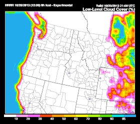
Finally, let me end by acknowledging that both my forecasts and the Weather Service's forecasts of the low cloud break-out have been poor. We both thought there would be more afternoon sun around Puget Sound. I don't want to give a lot of excuses, but as noted in my blog, this is a very difficult problem. And the fact that our key observing system over Puget Sound, the radar wind/temperature profiler in Seattle is broken is not helping. We need to push the technology to do better. I am encouraged that one of our new (but not yet fully operational) tools, the NOAA High Resolution Rapid Refresh Model, did a pretty decent job in forecasts the persistence of the clouds today:
Forecast of percent of low clouds at 2 PM for run starting at 5 AM. Not perfect, but useful


Paradise was gorgeous on Friday. I left the clouds about five miles south of the Graham turnoff on the Mountain Highway, and it was gorgeous the rest of the way.
ReplyDeleteI'm sure you've noticed that the NWS has been doing much worse forecasting this mess, if that makes you feel any better. I've quit looking at the local forecast on weather.gov, because all those little sun icons feel like a slap in the face.
All the local TV forecasters seem to be getting more apologetic by the day. Some of them are even saying that this isn't going to go away until the first of the month.
Say it isn't so? Please? Is there anything in the models predicting when this might be over?
I was in Portland Saturday. Even though the fog burned off, the air was really hazy and polluted, especially over North Portland. One could see this grayish brown layer just hanging over it.
ReplyDeleteEast Tiger Mountain was very nice yesterday afternoon, felt like about 70 degrees. Great view of Mount Rainier with the lowlands all filled in with a soup of stratus.
ReplyDeleteHere on the north oregon coast it has been spectacular for the past few weeks..sunshine every day...a few days have had morning fog but has burned off by mid morning. Woke up to another sunny morning and high of 70 today! can't complain!
ReplyDeleteThis site will give you an idea if the fog will lift today. Not looking very promising for Seattle!
ReplyDeletehttp://sat.wrh.noaa.gov/satellite/alternative.php?wfo=sew&area=west&type=vis&size=1
Cliff, I too went over the pass on Sunday and we climbed Thorp Mountain. With Seattle's polutants trapped below, it was warm at 5800 feet and the air was especially clear. We could easily see Mount Adams, over 60 miles away.
ReplyDeleteBut why can't we mix out this gloom we live in? Even the coast is having better weather that the Puget Sound basin. It seems to me that with the top of the inversion ouly a thousand feet up, a modest amount of wind would do the trick. Why do our highs produce so little wind?
Day 4 of dense fog here in Sequim so we drove up to Hurricane Ridge to catch the rays. Very nice and temps in the low 60's then we returned to the fog.
ReplyDeleteFunny thing is I was feeling the fog blahs on Sunday morning and decided to do the same thing! I loaded up my Mtn. bike and headed East spending
ReplyDeletea glorious day biking in 65 degree sun and blue skies! Only to return to the same, gray fog bank just east of North Bend. My thought... I'm moving to Easton!