Few areas of the U.S. enjoy such varied and variable weather as the Northwest. Last week we were stuck in Fogmaggedon, a very unusual string of dense fog days (most extreme since 1988) that were accompanied by light winds and a startlingly strong inversion. Temperatures varied by 30-40F between sea level locations and others on the slopes.
And then a sharp trough passed on Sunday and we moved into VERY strong northerly and northeasterly flow, with bright sun and cooler temperatures. The moisture levels of our air plummeted to values not seen since last spring. Do you feel your skin drying? The static electricity building in your carpeted rooms?
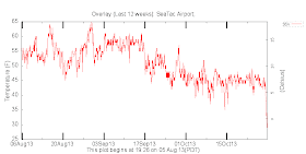
Here are the dew points the past 12 weeks at Sea Tac Airport. Remember dew point is a good measure of moisture in the air (low dew points dry, high dew points lots of moisture). Wow! Dew point dropped to 29F today, from the mid-40s of the foggy period, and MUCH less than that humid period in September.
Take a look at the last 72 hours of observations at the UW. Relative humidities (fourth panel down) have dropped to around 45%, with winds gusting to 20-25 knots. The bottom panel shows solar radiation....a perfect curve today since there were no clouds.
Here is the upper level (250 hPa pressure) map at around 35,000 ft yesterday showing the heights of that pressure surface and the wind speed at that level (in knots). This level is very close to the one most commercial jetliners fly at. The strong winds are in narrow ribbons...the jet stream. A high-amplitude ridge is over the eastern Pacific, with very strong (up to 160-180 knot) northerly winds. I was flying from the East Coast Sunday night and experienced these strong winds (and associated turbulence) close up.
The big ridge is associated with strong high pressure over British Columbia (see map), and the combination of a big pressure difference at the surface and very strong northerly
winds aloft produced areas of huge winds--particularly over eastern Washington. Here are the max wind gusts for the past 24h in that area (the Tri-Cities are in the lower right corner). 110 mph at Rattlesnake Mountain and 77 mph at another rest location. Lots of winds in the 40-50 mph range around the region.
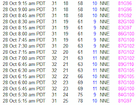
Take a closer look at the Rattlesnake Ridge winds. Mamma Mia! Sustained 80-89 mph with gusts over 100. These are truly hurricane-force. I bet the rattlesnakes are shaking tonight.
Can you imagine how envious those eastern folks are over our weather fun here?
With clear skies and cool/dry air over us, expect minimum temperatures to drop, particularly in sheltered locations. Many of you will experience 30s tonight and in some of the cooler/more sheltered spots, frost. Good time to protect your plants.
Seattle School Board Election Reminder
The school board race is a critical one this year and I am strongly recommending Sue Peters for the position. She has extensive experience in Seattle Schools and is a strong advocate for quality math. I know here very well. Her opponent, has had few interactions with the school district and is being supported by extraordinarily wealthy interests in the area who wish to transform our schools towards the corporate-ed model (Charter Schools, Teach for America, lots of testing). Don't let them take control of the district. Vote for Sue Peters if you live in Seattle.


Combination of dry air and breeze made for crackling maple leaves under foot on my walk through the forest this morning. Best word I could think of was crispy.
ReplyDeletehttp://www.nwac.us/weatherdata/missionridge/10day/
ReplyDeleteMission ridge hit 125. Doesn't look like the average windspeed thingy is working.
Windy indeed!! I was moving my sailboat to Port Townsend on Sunday for haul-out. It was exciting!
ReplyDelete