The official National Weather Service for western Washington tomorrow is favorable (sunny skies and temperatures in the mid to upper 50s), but are they being too pessimistic? Might tomorrow be much warmer and perhaps approach the record of 65F at Sea-Tac?
Perhaps. For the University of Washington in Seattle the NWS forecast is 56F on Monday.
The Weather Channel is 57F.
But UW Probcast (making use of statistical postprocessing of UW ensemble forecasts) is going for 64F!
Let's take a look at the latest runs of the UW high-resolution (4-km grid spacing) WRF forecasts. At 7 AM, it shows easterly flow and band of warmth in the Cascade foothills. You know why that warm band happens? Downslope warming along the western slopes of the Cascades.
And at 4 PM. WOW. Lots of temperatures in the 60s, some in the mid-60s!
Now I would take the potential for a very warm day seriously.
A warm front is moving northward across our region right now (see map), with a low and associated cold front approaching from the west.
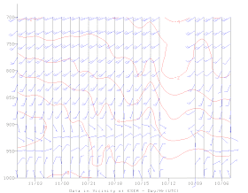
Data above Seattle right now shows moderate southwesterly flow above us now, with temperatures greatly warming over the past 24 h (by 6C or 11F).
With warm air above, the appearance of the sun, and strengthening easterly flow....a much warmer day is possible. It got to 52F today with overcast. Only a few degrees more with all the above going for it? On the other hand, if more clouds come in than forecast, temps will remain in the 50s. We shall see. Would be a nice gift for the veterans.
And did I mention the winds? The foothills may get blustery with moderate easterly flow (see graphic for tomorrow at 7 PM).


Say...do you ever cover Oregon? I life in the Mid-Willamette Valley. It seems to be one of the most difficult places on earth to decipher the weather... (sigh)
ReplyDeletemaking use of statistical postprocessing of UW ensemble forecasts as a statistician, i've always sought a way to process my data before it's available; but (dammit) so far my pre-cog efforts have forced me toward inferior postprocessing of the data. of course i don't generally have forecasts to pre-post process data after they're pre-available ;)
ReplyDeleteHi Cliff, Did you see this paper?
ReplyDeletewww.princeton.edu/main/news/archive/S38/31/66M12/index.xml?section=topstories&fb_action_ids=10201736092755405&fb_action_types=og.recommends&fb_source=other_multiline&action_object_map={%2210201736092755405%22%3A676653292353952}&action_type_map={%2210201736092755405%22%3A%22og.recommends%22}&action_ref_map=[]
Cliff:
ReplyDeleteI know this question is off topic, but it has been bugging me and I am sure you know the answer.
Why was the Philippine Typhoon traveling in an Easterly direction?
Looking at the current pacific infrared satellite there is a cyclone like system out in the Pacific (far offshore Washington/Oregon). Seems to be moving to the north/northwest. Is it anything of significance? When the next low moves onshore will that affect it's path?
ReplyDeleteCliff, love the blog as always! I have always enjoyed Intellicast because the way they present the information... Today, I found Intellicast Labs. I thought this was interesting - the surface wind maps especially. What do you think? Is this real science or just smoke and mirrors?
ReplyDeletehttp://www.intellicast.com/labs/
Thanks!
You were right! Though most of Puget Sound got only into the 50s, there was a record set at Quillayute of 66 degrees on Monday, but not until 10pm when Forks and Quillayute both jumped suddenly into the 60s and the humidity went down to 30s. See here:
ReplyDeletehttp://www.wunderground.com/history/airport/KUIL/2013/11/11/DailyHistory.html
I would be really interested in your explanation of how the temperature jumped 10 degrees in one hour and the humidity plunged down to 36% just before rain set in at midnight.