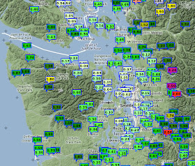
Let's start with the 24-h precipitation totals ending 9 PM on Friday (see below). A few hundredths of an inch over central Puget Sound, while a few dozen miles to the east along the western Cascade slopes some locations got more than 3 inches. The origin? A rain shadow in the lee of the Olympic Mountains. If you look carefully you will see very light precipitation to the east of the mountains of Vancouver Island, which has its own rain shadow.
The radar-based precipitation for the same 24 hours from the Seattle RainWatch web site also clearly shows the rain shadow (see graphic)
As does a radar snapshot at around 3 PM Friday afternoon:
The reason for this profound rain shadow to the east of the Olympics? We have quite strong westerly flow over us, flow that was associated with a disturbance originating in the Gulf of Alaska. To illustrate, here are the winds, temperatures, and heights of the 850 hPa pressure surface (about 5000 ft above the surface). 30-40 knot westerly to west-northwesterly flow hitting the Olympics. Where the winds take air upwards, you get enhanced precipitation. Where the air is rapidly descending (east of the Olympics), precipitation is attenuated.
The air still has water vapor in it even when precipitation is not falling; as the air is forced again to rise (this time by the Cascade), torrential rain and snow results.
High-resolution model forecasts knew such rain shadowing was coming. Here is the precipitation forecast made on Thursday afternoon for the 24h precipitation ending 4 AM on Saturday by the UW WRF model. Not perfect, but the essential pattern is there.
Very strong winds has moved into the Strait of Juan de Fuca late Friday behind the passing trough, with gusts to 50-60 miles per hour. Here are the max winds for the 24-h ending 9 PM Friday. Western Whidbey is being hit hard.


Interesting that you stayed dry on your commute to the UW.
ReplyDeleteMy ride from the Wedgwood neighborhood to the downtown REI around 11am was directly into the teeth of some pretty heavy rain.
off-topic possible-undergrad-499-project and maybe altogether meaningless weather question: "it's raining currently, how long on average, climatologically, should i wait until it's not raining? (per locality per seasonal week)". or said another (naive) way: "what is the half wavelength (in time) of a ridge-o-rain in seattle (for a given week of the year)?" believe it or not, this was the topic in the University YMCA's men's locker room. the consensus, for this time of year, was that one should wait about a day and a half; by which time one would only have to wait another half day.
ReplyDeleteTo Just Above...
ReplyDeleteTake the Fourier Transform of the rainfall pattern. Someone has probably done it.