Some forecasts are very hard and this is one of them.
The lowlands of western Washington have two shots at snow: Saturday morning/early afternoon and Sunday afternoon/evening/Monday AM.
The several weather forecasting models we have available are not in agreement on snow amounts and distributions, with temperatures being right on the edge for rain versus snow.
I am going to give my best shot at this, but it is important to check the forecasts often, since the situation should clarify as we get closer to the events.
Saturday's Potential Snow
Virtually all the models are in agreement that a weak disturbance will approach western Washington from the northwest on Saturday, with precipitation reaching the western interior just after daybreak. (see map for 10 AM Saturday morning below)
So we will have precipitation. Temperature will be the key issue. Looking at a number of models, it appear that there will be a distinct north-south temperature gradient--cooler to the north. As a result it looks like Bellingham and Whatcom County will see a few inches of snow and south of Seattle it will be rain near sea level. Seattle might see some wet snow initially over the higher hills, but precipitation will turn to rain during the afternoon. Better chance of light snow from Lynnwood northward. Here is the accumulated snowfall ending 9 AM from the latest NOAA Rapid Refresh model run. No snow in Seattle...but light stuff over Snohomish County northward.
The mountains are guaranteed snow..up to around a foot in the central Cascades.
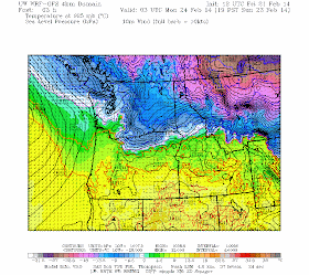
The bigger issue is Sunday. As the Saturday disturbance passes through, colder air will return to the lowlands on Sunday AM. At the same time, a warm front (with plenty of precipitation) is approaching, with precipitation reaching western Washington late Sunday afternoon. With low pressure with the warm front and higher pressure over BC, cold air will push southward, particularly through the Fraser River Gap (see figure). Here is the regional sea level pressure and temperature UW WRF forecast for 7 PM Sunday. Blue indicates cold temps, yellow warm temps.
Here is a close up view of the forecast at 10 PM Sunday...cold air and northerly flow over the Sound...cold enough for snow.
And here is the three-hour snow forecast ending 10 PM Sunday...light snow over much of the region.
The problem is that some models...like the gold standard European Center model...are a bit warmer, resulting in no snow near sea level on Sunday. Folks...we are right on the edge and small differences in the model solution will make all the difference in rain versus snow. Large uncertainty.
We will be watching the models and observations over the weekend...and hopefully the forecast will become more definitive in time. My gut feeling is that Sunday night/Monday morning will whiten up the Seattle area...but we will see.


We just cannot have an easy snow forecast!!!
ReplyDeleteI hope you're right with your gut feeling Cliff. I agree with you...temps are already cool. Mix/rain and snow today in showers at 500 feet where I was.
I will cross my fingers!
Thank you Cliff ... BTW I love your gut feeling for Sunday PM I hope it's right!
ReplyDeleteThanks a lot Cliff. I'll be hoping for snow.
ReplyDeleteI've been watching this setup for the last week and will not be happy unless snow goes down to at least the King/Snohomish line.
ReplyDeleteArg, the one day of the year that I DON'T want it to snow.... oh how I love the white stuff but I have an early morning flight to Phoenix for a week long vacay. Hope the cab can make it to my house to pick me up!
ReplyDeleteSnowing here in Oso already, a dusting on the ground. (Oso is a little east of Arlington)
ReplyDeleteSnowing ( but not sticking) with tiny flakes in Clearview! ( just east of Mill Creek) 9 am Saturday.
ReplyDeleteFalling, but not sticking, in downtown Kingston since 9am.
ReplyDeleteLast time there was a borderline chance of snow, Seattle was hit enough to cover the roads and give the buses issues. And the UW campus looks great in the snow. So I would love to have another little snow even blow through.
ReplyDeleteStarting to snow moderately in Bellingham southside. Sticking on the grass but not the roads yet. Temps dropping.
ReplyDeleteWe are at 400ft, and just walked up from the water where it is still raining - very marginal snow line. Apparently some of the higher hills in town have a couple of inches already.