Before I talk about the storms, lets review the current water situation (see graphic of snow water content across the west). Washington State is around 75% of normal, the Oregon Cascades about 45%, and the recent storms have brought the Sierra Nevada up to around 45%. We are in a far better situation than two weeks ago. The Rockies are doing quite well, which is quite important since the Colorado River headwaters are in fine shape.
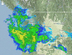
Right now, at 10:30 AM on Saturday, weather radar shows the next approaching system, with the yellows indicating heavy precipitation. Northwest Oregon is already being drenched and Seattle is about to get wet.
Here is the 72 hr forecast rainfall and snowfall maps, based on the UW WRF model. Impressive totals (5-10 inches) in the Olympics and Cascades, and importantly, northern CA gets a piece of the action.
The snowfall maps for the same period will bring a smile to skiers and water resource managers, with 2-3 feet over the mountains of BC and the Washington/Oregon Cascades. Having lots of precipitation in BC is good news for the NW, since that is where the Columbia headwaters are located.
This 72 h totals above includs precipitation from the storms coming in today and late Sunday. But other strong/wet storms are forecast to reach us on Tuesday and Thursday, so lets look at the subsequent 72 hr totals. Mama Mia! It almost looks like a repeat, with a bit less getting into California.
The reliability of our forecasts for the large-scale storms associated with the above precipitation totals is far greater than the frontal waves of last week's local snows...so it would be surprising if we don't get inundated as shown above. The NW River Forecast Center is predicting serious flooding on some western Oregon rivers.
The latest forecasts suggest high pressure will move in on Friday and Saturday, with cooler conditions aloft. I would expect extraordinary skiing conditions then...so get ready. By that time I would expect the Washington snow pack to be near 100% of normal, leaving us in great shape for the upcoming summer, assuming normal or even a bit below normal precipitation the rest of the season. But keep in mind that such a snow dump could lead to dangerous avalanche conditions in uncontrolled areas, so please check with the NW Avalanche Center's forecasts and warnings.
California's situation will improve, but they still need more major storms.
--------------------------------------------------------------------------------------------------
Announcement: The Northwest Weather Workshop will be on Feb 28th/March 1st in Seattle.
The NW Weather Workshop is the big annual gathering of those interested in the weather of the Pacific Northwest and everyone is welcome. For more information, including the agenda and registration information, please check out: https://www.atmos.washington.edu/pnww/


.gif)
.gif)
.gif)

Great news, Cliff. I just wish central California would get in on the action a bit more.
ReplyDeleteAnd yes, in spite of the snow forecast misses, I have noticed the excellent accuracy on these events. I regret complaining about the snow forecasts in our area. My apologies.
Your comments on this, Cliff?
ReplyDeletehttp://www.bbc.co.uk/news/science-environment-26023166
This week I've been struck by the impression... purely a VISUAL sense from satellite and radar graphics... that the jet stream has started moving again.
ReplyDeleteFor the last decade the jet stream was sluggish at best, stuck for months at worst. Now it seems to be slithering back and forth in a lively way that I haven't seen in a LONG time.
Hi Cliff,
ReplyDeleteSome v strong winds here in Bellingham for the last couple of hours. Also, the radar has more yellows and reds than I have seen in a while. Finally, there is a skinny line of really bright red echoes, heading towards Ocean Shores currently (around 6:20 pm.
All in all, this feels like it will quite a storm!
Can anyone explain the radar image over Port Angeles & Sequim right now (19:05 on Sunday)? Convergence zone? The sattelite image is interesting too just off-shore. An explosion of white cloud.??
ReplyDeleteHey Cliff..
ReplyDeleteI live out on Hood Canal at about 500 feet, Kitsap side. Would you believe me if I told you it SNOWED for more than an hour this afternoon???
Only about an inch of slushy snow...roads were covered.
HOOD CANAL STRIKES AGAIN
Anytime the snow level is 1500 feet or lower for most of western Washington and precipitation will be heavy along the canal...its probably going to snow, at least briefly, down to a much lower elevation here