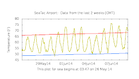
But something unusual has happened this year: practically no June Gloom so far! To show this, here are the temperatures at Seattle-Tacoma Airport for the past two weeks, with normal highs and lows also indicated. Many days have been well above normal, with seven days getting to 70F or above. The minimum temperatures have been above normal as well and there has been plenty of sun. But why has the gloom been kept away this year? First, some Gloom 101!
Gloom 101
Strangely enough, June Gloom is associated with high pressure building over the eastern Pacific and the associated formation of a huge area of low clouds. To illustrate here is a satellite photo on June 4th, our last gloomish day, with massive amounts of stratus and stratocumulus over the eastern Pacific! The offshore high pressure pushes the cool, cloudy marine air inland to the coastal mountain or the Cascades.
Here is the corresponding sea level pressure (solid lines) and lower atmospheric temperatures (colors, red is warm). Nice high pressure system over the eastern Pacific (the East Pacific Anticyclone).
But why does high pressure produce low clouds and June Gloom?
High pressure areas like above have warm air above the surface, while the ocean surface and adjacent air remain cool. That situation can produce a stable situation in which air does not tend to mix much in the vertical (warm, less dense air is above cooler, denser air). High pressure generally has relatively light winds, which also lessens mixing. So the air near the surface can be cooled and moistened by the ocean surface, without drier air mixing in from above. And there is more! Northerly flow forced by the high pressure causes coastal upwelling, with cold water ascending from depth. This cool water contributes to cooling the air down to saturation--giving you fog and low clouds.
But why do things get murky in June?
In late spring, this area of high pressure moves northward and strengthens offshore of us; earlier in the season there is still lots of weather systems moving through and the high pressure is mainly to the south. In June it is in its optimal position for the U.S. coastal zone to be enshrouded in clouds. Also, as the interior of the continent heats up in June, the air becomes less dense and pressure falls. Lower pressure inland encourages the Pacific air to move eastward .In July, the high shifts further north and enough air pushes southwestward across the coast to clear out most of the Northwest. Also, as the high gets stronger, the low-level cold air shallows so much that it can be mixed out by the sun during the day.
If you plot the maximum and minimum relatively humidities at Seattle during year (see graphics from Weatherspark), you will notice a small maximum in early June in both. A sign of June gloom meteorology.
The term June Gloom is heavily used in southern California as well, where they share the cooling impacts of the extensive low clouds over the eastern Pacific and onshore flow forced by the high offshore and low pressure associated with the heated interior And some folks stay in June gloom nearly the whole summer, such as the unfortunately citizens of Monterey, California and the Pacific side of San Francisco.
So why have we been so nice this year? The reason is that the East Pacific High Pressure area has been much stronger than normal, as illustrated by the following figure that shows the pressure anomaly (difference from normal) between June 1 and 6th.. The red indicates much higher pressure than normal offshore over the northern Gulf of Alaska.
Although most of us have been been quite happy with the sunny weather this year, there are some folks that have been disappointed by the lack of June Gloom. Considering their typical hours and usual hangouts (around Forks, WA), you probably won't run into them. Bring a silver bullet.


"there are some folks that have been disappointed by the lack of June Gloom. Considering their typical hours and usual hangouts (around Forks, WA), you probably won't run i"to them. Bring a silver bullet"
ReplyDeleteThose of us who are profoundly missing the June-Gloom would have the usually precise Professor know that silver bullets have no negative effects on us mythological few who would sensibly shun the skin-cancerous sun. (wood-stake-heart: vampires; silver-bullet: werewolves thus spake hollywood (mummies are left as an exercise for the student))
Dr. Mass, is this a similar phenomenon to the persistent summertime marine layer in the San Francisco Bay Area?
ReplyDeleteVAMPIRES SUCK
ReplyDeleteThe fog has mostly kept offshore so far, but we have had intense north winds for the last 10 days or so here in Newport.
ReplyDeleteThe beaches are not nice to hang out on unless you want the feeling of being sand blasted while freezing.
This has definitely been a weird year for weather...it will be interesting to see if the predicted El Nino makes it even more so if it shows up.
I just call it June-uary.
ReplyDeleteI'm just looking forward to July pie.
ReplyDeleteIs there any potential correlation between the magnitude of the high pressure and the warmer than normal Pacific water temperatures in the same area?
ReplyDeletemeteorologists / meteorology speak are/is confusing when they always use PRESSURE to explain weather....
ReplyDelete