Wrong paradise. I am talking about Paradise on Mt. Rainer at around 5500 ft in the Washington Cascades. Yesterday and this morning they actually had some snow up there, as illustrated by the cam shots below:
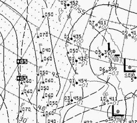
The reason? A cold, upper-level trough has moved over the Northwest: here is a very short forecast for 8 AM this morning at 500 hPa (about 18,000 ft) showing heights (like pressure), winds and temperatures (color shading). Blue is cold.
The upper level chart at 850 hPa (about 5000 ft) this morning at 5 AM show temperatures at both the Quillayute and Salem radiosonde stations of 1C at this level under cold northwesterly flow.
Although global warming will have serious impacts here in the Northwest later in the century, the snowpack in our mountains has remained healthy--particularly at higher-elevation locations like Paradise. To show this, here is plot of the amount of water in the snow (snow water equivalent or SWE) on June 1 at Paradise (at a unit called a snotel) for the last thirty years (the red line is a five-year running average). If anything, the snow pack at this level is increasing.
 |
| Information gather by Mark Albright, UW. |
The 83.2 inches of snow water at the Paradise Mt Rainier snotel on June 1 marks the 6th greatest June 1 snowpack out of the past 31 years at
Paradise Mt Rainier. The median snowpack is 63.6 over the past 31
years, with the past 7 years (2008-2014) have all been above the median June
1 snowpack.
And what about the date of snow melt out? We have a 97-year record at Paradise and the mean melt-out date is 11 July. From 2000-2009 the mean melt out date was 10 July. From 2010-2013 the mean melt out date has been 30 July! Bottom line: snow is not melting out earlier at this location.
Before I get harangued by those worried about global warming, it is important to stress that global warming from human-enhanced greenhouse gases will cause the Cascade snowpack to lessen later in the century. But not yet, since the cooling effects of the ocean and natural variability are still dominant around here.


Would one expect to first see an effect from climate change at 5000+ elevations? Are we already seeing other indicators? For example has the average midwinter snow line (closer to 3000 feet) changed? Or what about the rate of glacial retreat? Has that accelerated over the past 50 years? I understand that the noise from ENSO and PDO confound the climate signal, but have we detected no climate change signal at all in the north cascades It doesn't seem that snowpack at 5000+ feet would be the most sensitive indicator since there is a 2000 foot buffer in place.
ReplyDeleteIt seems that the PDO might be playing a role here as there have been several springs post the classic April 1 snow pack date where snow has been added to the higher elevation snow stations. Regardless, glacial ice accumulation zones on most Washington glaciers have continued a downward trend. Summer temperatures may be even more important than winter and spring snow accumulations for our glaciers. That said, it would appear that loss of critical snow water storage problems has not yet begun.
ReplyDeleteI see on the Snotel SWE map that the Olympics are at 0% Yikes?
ReplyDeleteCliff, could you address this study in one of your blog entries?
ReplyDeleteIn the West, what used to be snow, falling as rain
http://www.inkstain.net/fleck/2014/06/in-the-west-what-used-to-be-snow-falling-as-rain/