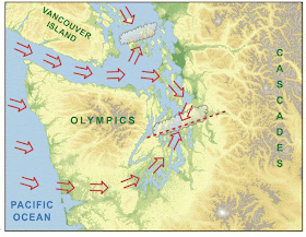
Although the convergence zone location shown in the figure above is quite frequent, it can shift north or south depending on the direction of the coastal winds. For example, if the incoming flow is more southwesterly, the convergence zone tends to shift north...often positioned from Everett to central Whidbey Island (see graphic).
The Puget Sound convergence zone is probably the most important local feature of Puget Sound meteorology, typically occurring 10-30 times per year.
But something that is not as well known is that convergence zone precipitation often extends far eastward of Puget Sound, often intensifying precipitation over the windward slopes of the Cascades, at the Cascade crest, and sometimes a bit on to the eastern slopes. And such major downwind convergence effects are forecast today.
Here is a high resolution WRF model forecast over western Washington for 11 PM Saturday, showing near-surface (10-m) wind speeds (shaded) and wind bards (which show direction and speed). Look carefully and you will see the winds along the coast are southwesterly (from the SW), with air splitting around the Olympics and converging into an area of light winds over northern Puget Sound.
Here is a high resolution WRF model forecast over western Washington for 11 PM Saturday, showing near-surface (10-m) wind speeds (shaded) and wind bards (which show direction and speed). Look carefully and you will see the winds along the coast are southwesterly (from the SW), with air splitting around the Olympics and converging into an area of light winds over northern Puget Sound.
Now let's look at the forecast precipitation for the 3-h period ending 11 PM Saturday. Can you see the band of precipitation stretching SW-NE from central Puget Sound into the north Cascades? That band is associated with the convergence zone. Some folks camping in the north Cascades might get wet tonight. You will also notice some upslope precipitation on the western sides of the Cascades.
If you really want to get in a wet mood, here is the precipitation forecast for the 24-h period ending 5 AM Sunday. The western foothills are wet (1/3 to 2/3 inch of rain), but that area of convergence zone influence is really unpleasant (1-2 inches).
The extension of convergence zone precipitation into the Cascades is known to many skiers, who enjoy the snow-enhancing impacts of the convergence zone on Stevens and occasionally Snoqualmie passes.
Finally, our weather has worsened the last two days because we lost the east Pacific high pressure and an unusually strong jet stream is directed east-west across the Northwest. Here is the upper level (300 hPa, about 30,000 ft) heights (like pressure) and winds at 11 PM Saturday (colors give wind speeds, with yellow being strong). Really strong westerly upper level flow for this time of the year. I flew from Denver to Seattle this morning and it was an amazingly LONG flight with such headwinds.
Fortunately, the atmosphere will reconfigure on Sunday and Monday, and a warming spell will arrive, with temperatures rising above 80F on Tuesday.


Thank you so much for your ongoing teaching via this blog. I am an avid skier and boater and weather is everything! There are too many gaps in my understanding of meteorology, so I truly appreciate your "patient" explanations. Thank you!!
ReplyDeleteHi Cliff, from a Whidbey fan.
ReplyDeleteI searched "chem trails" on your blog and was surprised to get no hits. Seems unlikely you've not addressed what appears to be an increasing phenomenon. Can you direct me if I'm missing something?
Thanks for all your good work!
drew
http://cliffmass.blogspot.com/2013/08/chemtrails-versus-contrails-do.html
DeleteIt's only an "increasing" phenomenon because of your confirmation bias. If you mean since the commodification of air travel, then sure- I'll give you that. But recently? Nope.
How does it look for the Fourth of July and the fireworks? We're considering driving out to Port Townsend because the whole day can be very pleasant there if the weather is good... but the beautiful summer weather's not really reliable until my birthday (7/11). :-)
ReplyDeleteThanks!
It seems here in Wenatchee we get some of our best rainbows when the convergence zone makes it over the Cascade crest.
ReplyDelete