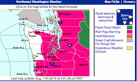
How often do you see the National Weather Service putting out a RED FLAG WARNING for western Washington? (see image below)
A Red Flag Warning is given when the National Weather Service expects extreme burning conditions.
Hot temperatures, dry air, some wind, lightning, instability--we will have all the ingredients in the west.
Think that the western side of the mountains can't get the big fires we are seeing east of the Cascades?
Think again. There have been huge fires on the western slopes of the Cascades and there are lot of big trees to burn once an event gets started.
Like the 1902 Yacolt Burn in SW Washington.
The temperatures on the West side were amazing on Monday, with a number of stations getting to between 95 and 100F. Many daily records have fallen.
Take a look at the 24-h max temperatures ending Monday evening. Some temperatures above 100F in the interior of SW Washington and a few 100s even on the east side of Puget Sound. Sea Tac got to 96F!
A close up view around Seattle is impressive: mid 80s even near the water and a few 100F reported. I suspect some of the really high temps had some exposure problems, but still it was very warm.
What about the temperatures of the roads? The Seattle SnowWatch application reports road and air temps. Here are the reports at 4 PM (road temps in the boxes). 113F on I5 over N. Seattle. 116F near Woodinville. No worries about ice on the roads today, except for those needed for iced drinks.
On Monday night, thunderstorms were moving into Washington from Oregon, with a strong cell descending into western Washington southwest of Seattle (see the radar around 8 PM).
There were a number of thunderstorms embedded in this precipitation, as illustrated by the 1/2 hr lightning ending 7:30 PM Monday (each - or + is one lightning stroke).
We should be concerned about the ignition of more fires by this lightning.
Tuesday should see a step down in temperature due to clouds, but the real rain and thunderstorms should wait until Tuesday evening and Wednesday.


Pretty nice lightning storm for the last 45 minutes, in Wedgwood-View Ridge!
ReplyDeleteexcellent lightning show from Redmond WA. Plus a near full moon rising below the cloud deck
ReplyDeleteThink the 100 readings may not be artifactual--my car thermometer, which seems to be well calibrated when in motion, picked up two 100 degree hot spots near Renton Monday afternoon.
ReplyDeleteAnd where do you find all those nice map summaries of local precip and max and min temps that you use to illustrate your blogs?