Although summer still has one more month to run, the extraordinary warmth of the past two months is putting us on a track whereby we might achieve that record. Here is the average departure of the maximum temperature from normal from June 21st until now. The Northwest is well above normal, particularly over and east of the Cascade crest.
Minimum temperature? Same picture.
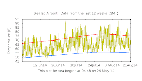
We can compare the temperatures at Seattle Tacoma Airport, Yakima, and Spokane against the normal highs and lows (see figures). For roughly 2/3 of the days, the max temperatures are higher than normal (the red line), with many days 5-10F warmer than normal.
July was the first or second warmest for many stations around the Northwest and, as shown above, August was even more anomalous.
The latest Climate Prediction Forecast for the next 6-10 days is... you guessed it. Warmer than normal over Washington and Oregon.
Temperatures this summer are running roughly 3F above normal. Following the median global warming scenario, this is like advancing 30-50 years into the future. So this summer you are getting an idea of the conditions you or your children will experience in approximately 2050.

.gif)


If that is the case, bring on "manmade global warming"!
ReplyDeleteI think so, Cliff. You ought to see my giant RIPE Brandywine and Old German heirloom tomatoes. Planted from seeds in mid-March and I put them out in late April.
ReplyDeleteThey tell the tale...and yes, you bet I am proud.
I would have thought that the summer of 1979 would have been the hottest summer on record, but maybe that is just for Western Washington. That year has the record for the longest streak of over 80F degree days. I don't remember the exact count but I think it was over 60 straight days above 80.
ReplyDeleteWhile this summer has been to warm for my tastes, it has been a great one weather wise. Before it gets this warm on a regular basis, I'll have AC in the house so that it isn't 80F inside by evening time.
Our local newspaper reported July highs averaged ≈6ºF and night lows averaged 5ºF greater than 1985 record.
ReplyDeleteWalla Walla
Totally agree with ryamkajr! If this is what global warming is going to look like in the NW, summers around here will be even more amazing. However, interesting to note that the other 2/3rds of the country has been cooler than normal and in some cases substantially cooler. All balances out in the end. ;)
ReplyDeleteOddly enough down here in western Lewis County we are only 1 or 2 degrees warmer nighttime lows and daytime highs. Good but not outstanding for the tomatoes, eggplants, and peppers.
ReplyDeleteI will be glad when the fall sets in and we get cooler temperatures back. Having grown up in the South I've grown to hate anything above about 70 degrees.
ReplyDeleteThe biggest issue with this summer so far has been the excessive humidity. Never have I seen so many stretches of 60+ dewpoints in Seattle. I moved here to get AWAY from all that!
ReplyDeleteI second the comment regarding the humidity. If you see these comments Cliff can you post an explanation as to why the humidity was so consistently high for much of the summer. The dew point stayed in the low to mid 60's with occasional spikes into the upper 60's for several weeks straight. Unlike 2010 where there was a strong tropical moisture tap at one point to provide record dew points, this summer there didn't seem to be an obvious source for the persistently high humidity.
ReplyDeleteThanks!
Not that bad of a future - looking forward to it!
ReplyDeleteJust eyeballing the graphs, it appears that the daily low temperatures have been above normal much more frequently than have the high temperatures. Wondering if there has been any analysis of this, as well as quantifying trends in dew points (I share the impression reported by other posters that it hs been higher).
ReplyDeleteAlso, is there any chance that changes in conditions around reporting stations are affecting comparisons over time, including records?
http://cliffmass.blogspot.com/2011/07/did-sea-tacs-third-runway-change-our.html
Kevin, I would concur that the above normal low temperatures have been the story here. Instead of nightly lows ranging from 52-60, we've been experiencing something like 55-63, with a higher than normal water vapor load putting a limit on the nighttime cooling.
ReplyDeleteAs we start losing solar flux over the coming weeks, I think we can look forward to many foggy nights until this humidity gets washed out of the atmosphere by cold oceanic air.
How can there be a 6 to 10 day "climate" forecast?
ReplyDeleteIt has been a miserably hot summer over in eastern Washington...
ReplyDeleteThese lovely days for tomatoes and gardens are making me concerned about our irreplaceably lovely environment. If there's anyone in Seattle who thinks losing our trees would be ok, I'd be surprised. But doesn't this temperate rain forest depend on our grayness and dependable rain? I'm much more a druid than a gardener and would gladly have gray rainy days if it means we can keep our dark forests and dense undergrowth!
ReplyDelete