The BLOB is not well.
You know from my previous blogs that I have a special affection for the persistent pool of warm water over the eastern Pacific, one endearingly called the BLOB by local climate-guy Nick Bond. It was produced by unusually persistent high pressure over the eastern Pacific, which among other thing led to less mixing in the ocean. Less mixing of cold water from below to the surface resulted in a pool of warm water, 2-4C above normal.
We liked the BLOB because it probably was a contributor to our above-normal temperatures in summer and early fall.
But the BLOB is in trouble.
Let me show you....and I warn those of your with a squeamish nature to switch to another blog so you avoid nightmares. And don't allow children to read any further.
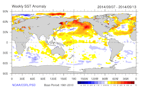
Here are the sea surface temperature (SST) anomalies (differences from normal) for a week in early September. BLOB is healthy. SST anomalies of 2-4C.
Then examine the same sea surface temperature anomalies but for the week ending October 24th. BLOB is sick in the Gulf of Alaska, but there is still warm water near our coast.
And now look at the anomaly for yesterday. BLOB is in trouble. The water is now COOLER than normal in a large area of the eastern Pacific and the warm water along the coast has lessened.
So why is our old and welcome friend. the BLOB. in trouble?
It is because the atmospheric circulation has radically changed compared to last fall. Instead of a persistent ridge, we have had a persistent trough, with strong winds, storms, and lots of wave action.
Take a look at the average sea level pressure for October 15th-28th. A deep low in the Gulf of Alaska.
And here is the difference of the pressure from normal for the same period. An unusual area of low pressure in the same place.
Low pressure is associated with storms, winds, and lots of waves that mix up the cold water from below the surface. The result is rapidly cooling of surface water and a very sick BLOB.
There will be plenty of weather action over the Pacific during the next week, so I don't expect the BLOB to recover.
A bittersweet reminder to value BLOBs when you have them.


RIP, dear BLOB. I will miss you....
ReplyDeleteSo the demise of the blob is responsible for the 6+ inches of rain this month?
ReplyDeleteSo should people buy season ski-lift passes? LOL
ReplyDeleteRIP, Blob.
Rot in hell blob!
ReplyDeleteDoes this mean our chance for a normal winter are improving? With this affect the long range predictions NOAA issues?
ReplyDeleteBob Tisdale analyzes the same thing here:
ReplyDeletehttp://wattsupwiththat.com/2014/11/01/on-the-recent-unisys-sea-surface-temperature-anomaly-maps-and-cooling-of-northern-hemisphere-ocean-surfaces/#comment-1776816
And this Nick Stokes says,
"Bob, here is my AVHRR movie of the last 50 days in North Atlantic SST. It doesn’t show any notable cooling.
http://www.moyhu.blogspot.com.au/p/sst-regional-movies-as-described-here-i.html?WxK=7
Could be some interesting comparisons and/or collaboration.
return of the blob? i wanted to go to westport, charter a boat and go "blob watching." next summer perhaps?
ReplyDeleteFarewell, sweet Blob! We hardly knew ye...
ReplyDeleteAt the risk of being spammy, here's the petition to the government about the funding for the weather-prediction supercomputer that Cliff wrote about in his last blog. We the People petition It's easy to sign; enter very basic information and then click a link in your email confirmation message. We have about 20 of the 150 signatures needed to make the petition show up in searches and maybe the front page of the We the People site. Thanks
ReplyDelete