First, the latest satellite picture. You can see the swirl of clouds associated with the low due west of northern California. Clouds extend northeastward from the low (in an occluded or bent-back warm front). Nice pic.
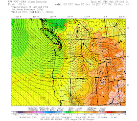
Let's look at the latest UW WRF forecast (solid lines are isobars, lines of constant pressure). We start for the forecast at 2 AM Saturday morning. Strong low, with a central pressure at 985 hPa (millibar). Strong, but nothing like the great storms like the Columbus Day Story (around 955 hPa)!
By 2 PM Saturday, the low reaches the SW Washington Coast. Big pressure gradient and associated winds along the Oregon coast. The low has filled a bit (987 hPa).
By 11 PM, the low moved across the Olympics and reached southern BC.
Big pressure gradients over western Washington...it will be windy then....gusts to 30-40 mph are quite possible.
There is another wind threat that will be more localized. As the warm front moves northward tonight, you can expect accelerating winds along the western slopes of the Cascades from Enumclaw to North Bend. Gusts to 40 mph are probable.
Here are the forecast gusts at 5 AM Saturday morning. You can see what I mean about strong winds along the western slopes.
At 10 AM Saturday morning, the low is off the central Oregon coast and huge winds are found along the Oregon coast. Winds OVER 70 knots. If you are on the Oregon coast, either get away or get prepared...these will be severe conditions if the forecast model is correct.
As the low moves northward across out region late tomorrow afternoon/evening winds will accelerate...here is the strong at 5 PM. Gusty wind pushing up the Sound and VERY strong along the central and southern WA coast (to 50 kts).
Six hours later, as the low moves north of us, the winds will remain strong in the Sound, but will get very powerful (50 kts plus) in the Strait as air accelerates eastward in the gap.
And yes, plenty of rain. Here are the totals for the next 48h.
Very wet along the coast and in the north Cascades 2-5 inches). We are experiencing a very second half of October, with much of the region already way above the normal monthly totals...and we have a week left to run.
Keep in mind that although this is a very recent model forecast, there is still some uncertainty with this event. One source of additional uncertainty is that the weather satellite information feed was discontinued for 1-2 days to the National Weather Service modeling group. The implications of this failure is not clear, but losing data over the ocean is a problem for us.
Another potential storm on Tuesday..but that will have to wait until another blog.


.gif)
I love the feisty weather of October / November. My regret is that I cannot run to the beach this weekend.
ReplyDeleteThis comment has been removed by the author.
ReplyDeleteWhat about Ana reforming in the northern Pacific and headed this way? Obviously it will lose some strength but Im wondering about rain amounts if it comes close to WA.
ReplyDeleteHow does this compare to the November 2nd storm of last year?
ReplyDeleteNice work Cliff ! Am enjoying the die-down of what must have been a rapid moving low. Great forecasting. Would love to see a time-lapse. Can we name this or too wimpy?
ReplyDelete