Central Puget Sound residents do not frequently think about living in a rain shadow, like their friends in Sequim and Port Townsend. But more frequently that you might expect, Seattle IS in a rain shadow and this will happen later today.
Seattle, with roughly 37 inches a year in annual precipitation, is far drier than the Washington coast, even places away from any terrain. For example, Westport, on the central Washington coast, gets about 74 inches....about twice a much as Seattle. The Long Beach Peninsula gets 81 inches.
The Puget Sound rain shadow is so profound that Seattle gets less rain than Chicago, New York, Washington, D.C. or Miami.
Our rain shadow is most evident when the winds along the coast are westerly (from the west), because of their interactions with the Olympics.
When the winds are from the west, air rises on the western side of the Olympics (producing heavy rain) and descends on the eastern slopes (causing drying).
During the past few hours (Saturday AM), a warm front has passed through our area (sorry skiers), bringin warm air and a shift to westerly flow. To illustrate this, here is the forecast heights, winds, and temperatures (shaded) at 850 hPa (about 5000 ft) for 4 PM Saturday (today). The wind are parallel to the height lines and the closer the lines are together, the stronger the winds. What you see is very strong westerly flow surging into our area, with red colors indicate very warm air. You can get strong Puget Sound rain shadow with such a pattern, as well as heavy rain on the western sides of the coastal mountains and the Cascades.
This air is also very moist, something suggested by the 10 AM water vapor product from satellite data (see below). We have an atmospheric river today, with a narrow streamer of moisture extending from the tropics into our region.
Now the fun part. Here is the predicted rainfall for the 24h ending tomorrow (Sunday) at 4 PM PST. Wow...heavy precipitation in the mountains (as much as 2-5 inches) but a very strong rain shadow from Seattle westward over the Kitsap. Only a few hundredths of an inch in some places.
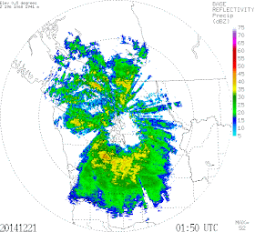
Here is a radar image around 6 PM for the Seattle area. A beautiful example of rain shadowing east of the Olympics!
What I like about this flow direction is that Sequim is way wetter than Seattle. What I don't like is that there will be a lot of warm rain falling on the limited snow in the Cascade. Stevens Pass opened for limited skiing today, with a 17 inch base. Baker opened as well. Bring old skis.


Great evidence of the rain shadow at 17:30PDT of the UW radar loop!
ReplyDeleteSeattle is perfectly surrounded by rain!
Double rainshadow actually. Another east of Vancouver Island.
ReplyDeleteNearly NO rain shadow today here in Olympia. It's been raining constantly since sunrise, not a huge amount ~1.5", but precip steadily all day until about 9pm, when the winds whipped up, the temp hung in there at 55F, and we began to see some stars!
ReplyDeleteGenerally a day of little redeeming value, leaving standing water or mud everywhere, it seems.
Mission Ridge is open and has been for five consecutive weekends and is now in operation 7 days a week with expanding terrain and lift access...the focus on the large areas close to Seattle is important but there is no reason to leave out the fact that Mission is open and has been for quite some time.
ReplyDelete