The average maximum, minimum, and daily monthly-mean temperatures are all within 1F of normal (the average values for the month for 1981-2010).
So does that mean we experienced normal temperatures most of the month? The answer is NO!
To illustrate this, here is a plot of the temperatures each hour for November, plus the average daily highs (red) and lows (blue).
The temperatures on any particular day have been ANYTHING but average. The first ten days or so were MUCH warmer than normal, with most days having maxima and minima far greater than average. Then we had a 8-9 days of far colder than normal temperatures, followed by another period of much warmer than normal temperatures, followed by a much colder than normal end to the month.
Very few days were anything like normal with a high on the red line and a minimum on the blue line. Yet, when you average these substantial swings you get normal conditions.
Folks..this is not unusual. Very few days are normal and averaging conditions for a month, a year or whatever can be very deceptive.
This is going to be a very wet week for the Northwest and northern California, with a deep trough over the eastern Pacific that will bring very moist, warm air and the jet stream right into us.
To illustrate, here is the flow pattern near jet stream level (300 hPa, 30,000 ft) for Wednesday morning. Colors are wind speed (yellows and oranges are strongest), wind barbs, and heights (like pressure). A trough over the Gulf of Alaska and a strong jet heading towards the West Coast. This is a very "juicy" pattern for us.
Let me show you the for the precipitation forecast for the next 72-h (ending 4 PM Wednesday) and be prepared to be impressed. 10-20 inches over the Olympics and mountains of Vancouver Island. Up to 5 inches in the north Cascades
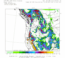
What about snow? Not much except for the BC Cascades. The reason? This is going to be warm air. Very bad for ski prospects in the Cascades.
What about snow during that period? With the jet going south, temps will cool a bit over the Northwest, allowing snow at higher elevations (up to a foot perhaps about 4000 ft). But the real snow story is in California where the high Sierra will get several feet. Really good.
There is much I don't have time to go into now. Strong winds, particularly along the coast. Potential windstorm over Oregon later in the week. And, of course, the potential/near certainty for flooding.
Rake your leaves today, clear your gutters, and make sure the street drains are open!


.gif)


Dr. Cliff,
ReplyDeleteThis post is just reinforcement for why I love Cliff Mass Weather Blog. How very interesting, current, and educational. Wow!
I love this news for California. Superb. Say what you will, but California is the greatest state in the United States. By far.
ReplyDeleteCalifornia has it all and now it looks like they will receive some much needed precipitation.
Washington state is VERY fortunate to have such a great neighboring state.
Hi Cliff,
ReplyDeleteOutstanding blog. I'm curious about the predicted snow in the BC Cascades. I'm seeing forecasts of 2k-2,400k meter snow levels at Whistler, Revelstoke and even Sun Peaks (all alpine, not valley forecasts) for Tuesday and Wednesday - i.e. rain up REAL high. And yet, the image shows the area around what appears to be Coquihalla Pass getting snow. Sorry if this is way too specific a question, but it seems bizarre to me that place well to the north and east, at often much higher elevations, would be forecast to be warmer and rainier. What the heck?
It's so simple to summarize this forecast: YAY!!!
ReplyDeleteRain much needed, warmth is fine by me (no lover of lowland snow), FINALLY planted my California lilac bush purchased in (ahem) July and not planted for multiple reasons, mostly poor... so thanks for the good news.
Looks like the "rain for California" dance and all sorts of other superstitious nonsense we engaged in have worked. Again, yay! My asparagus-loving self is so glad that next spring might actually stand a chance at being a good one for all my favorite delicious wet green plant things.
LOL
I'm being picky, but "Normal" really doesn't exist, as Cliff's graphics show. We are talking about averages, after all. Bugs me when the TV heads say normal, too.
ReplyDelete1 to 5 inches!
ReplyDeleteRaked all the leaves,
Cleaned out the gutters,
Bring on the pineapple express.
Reminds me of W.H. Auden: Stop all the clocks.
Andy
ReplyDeleteThe areas in the B.C. mountains getting snow are well north of Coquihalla Pass (and somewhat west). On the Map you can see the Fraser R. as it heads north out of Hope. Coquihalla Pass is east of the Fraser R. It's not until the end of the week that Coquihalla/Revelstoke etc start to cool enough for snow. Also, it's a 12km grid, which isn't very accurate for mesoscale features like a mountain, pass etc.