A lot has happened during the past day and a lot more will happen during the next 48h. Heat records will be broken, wildfires will start, and the impact of a very warm Pacific will be felt. Interesting but serious weather.
The last day brought very warm weather to our region, particularly east of the Cascade crest and in the Willamette Valley. Here the high temps yesterday over eastern Washington. Much (most) of the Columbia Basin went above 100F and a few locations exceeded 105F.
A number of daily high temperature records were broken:
It will be warmer today.
The Willamette Valley was torrid yesterday. Here are the highs. Many locations were in the upper 90s and several got to 100F! I don't believe the 109F, by the way.
Eugene tied their all time record high (98F). The fact more locations did not break any records shows you how warm the Willamette Valley, somewhat isolated from Pacific influences, can be. But what what was really remarkable about the Willamette Valley temps were the low temperatures, with several locations breaking record JUNE (monthly) records for high minimum temperatures (didn't cool off at night). Here are the official numbers from the National Weather Service. Impressive.
Puget Sound maximum temps? A walk in the park in comparison, but still well above normal. Mid to upper 80s away from water, 60s near the water. Thank god for our cool water, something Portland does not enjoy. The Seattle Office tied its daily record...no big deal.
But there was something remarkable about the temperatures even in Puget Sound. We got quite warm WITHOUT OFFSHORE FLOW. Normally, our big warm ups require offshore flow to push out the marine influence, but not this time. I suspect the reason is that the eastern Pacific is so warm that it is allowing such warmth even when the low-level flow is weakly onshore.
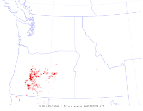
Yesterday, southerly flow developed aloft and moist, unstable air starting pushing aloft into the Northwest. In fact, there were a number of thunderstorms in south/central Oregon--here are the lightning strikes on Friday:
You can see the moisture streaming northward in a recent infrared satellite image:
The latest UW WRF model high-resolution forecast for 5 PM today (which should be near the high) shows eastern Washington getting very warm, with highs getting up to 104-108F in the warmest places. Portland is around 100F and the Puget Sound area in the mid to upper 80s.
The latest visible imagery shows instability showers over Oregon. Expect scattered thunderstorms over Oregon and the southern WA Cascades today.
But tomorrow and Monday will be the really interesting days. A series of upper level troughs will move through, bringing showers and thunderstorms, particularly later on Sunday and Monday AM. Temperatures will drop back by 5-10F on Monday and Tuesday, but temperatures may spike over eastern Washington from Richland to Spokane on that day.
The Weather Channel is going for 107F in Spokane on Sunday. Here is the 5 PM forecast from the UWWRF system on Sunday. WHITE HOT over eastern WA with warm easterly flow. Off the scale. Amazing. There will be records. And several locations will get above 110F.
And precipitation? As the upper trough moves through and cooler air moves eastward late on Sunday, there will be plenty of thunderstorms. Here is 24h precipitation ending 5 AM Monday. Lots of rain. And with that rain there will thunderstorms.
Needless to say, with lightning coming after the furnace-like temperatures of the past few days, the fire risk will be extreme. Governor Inslee has called a statewide burn ban, which is wise. Yesterday, he went further, calling for folks to forgo fireworks this year. Another good idea. Firefighters will have enough in dealing with natural lightning fires....they don't need human-caused fires on top of that. All fireworks sales should be banned. Particularly considering the forecasts.
And now the really serious news. After a few days of moderating temperatures (still well above normal), the forecast models are suggesting a huge ridge of high pressure will develop next week, one that will produce MUCH HIGHER TEMPERATURES west of the Cascade crest. Mid to upper 90s in Seattle are possible. Some western WA locations will get to 100F.
This is serious folks.


Just wondering Cliff if you have seen weather this warm before without air moving from the east?
ReplyDeleteSo everyone- if you see or hear something, do something. Zero tolerance for camp fires, beach fires, fireworks, carelessly discarded cigarettes, or any incendiary element.
ReplyDeleteThanks, Cliff.
ReplyDelete-Rod
Is there any hope for cooler temperatures in the long range forecast or is this how it will be ALL SUMMER LONG?? I moved here to get away from heat and this is not what I signed up for! Please make it go away!
ReplyDeleteI believe that there is no actual fireworks ban as of now.
ReplyDeleteSo some places will still be lighting them up.
Any plans for that?
Brings to me that almost too late feeling.
ReplyDeleteThere is a petition to have Gov Inslee execute his authority as governor to declare an immediate, statewide emergency ban on use of consumer fireworks if you are interested in signing it. https://www.change.org/p/jay-inslee-execute-your-authority-as-governor-to-declare-an-immediate-statewide-emergency-ban-on-use-of-consumer-fireworks-5189ce37-c5fd-41a8-a7ed-e2280ea75e61
ReplyDeleteThunder heard in Kingston Sunday around 10AM
ReplyDeleteThank you! I signed and shared the petition about fireworks across my 3000+ friends.
ReplyDeleteAny idea of when we will get a break from this heat?
ReplyDeleteHi Cliff,
ReplyDeleteWashington state is not alone for record heat.
Unprecedented June Heat on Four Continents; Wimbledon Roasts in Record Heat
http://www.wunderground.com/blog/JeffMasters/comment.html?entrynum=3031
(Note: There is a conversion error in the first paragraph of Jeff's blog: 34.6°C is 94.3 F not 96.3 F.)