Here is a MODIS satellite image during Tuesday afternoon. Loads of smoke north of Seattle, with particularly dense smoke around Everett. But south of Seattle it clears dramatically.
Smoke like this tends to cool the surface by scattering some of the solar radiation back to space. Here are the radiation measurement at the UW on Tuesday (yesterday), when lots of smoke was around, and on July 4th, when the skies were pretty clear around here.
If you look carefully, you will see there was substantially less solar input yesterday--the numbers show about a 15% reduction. Weaker sun means less warming.
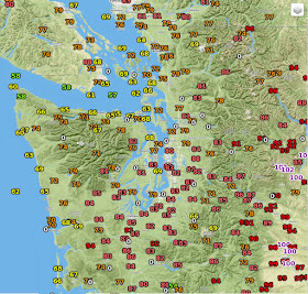
Well, if this theory is correct we should be able to see it in the high temperatures yesterday...let's check it out. South of Seattle there are lots of temperatures between 82 and 85F. This is true even with some cooler marine air and low clouds pushing into that area Tuesday AM. But north of Seattle most land stations east of the Sound and Georgia Strait were in the 70s--Bellingham was only 72F!
The smoke thickened over and north of Seattle during the afternoon and you can see the impacts on local temperature records. Here are the temperatures at Paine Field (Everett), UW-Seattle, and Olympia.
Normally temperatures peak between 5 PM and 6 PM during this time of the year (17:00 -18:00 PDT). That was true of Olympia, which was out of the smoke. But as you got deeper into the smoke, the time of max temperature got earlier, around 4 PM at Paine Field, for example. This makes sense...with weaker sun the temperature peaks earlier when the sun is stronger. You will also see a HUGE difference in temperature: 71F in Everett and 85F in Olympia.
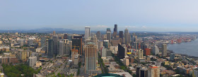
The smoky conditions north of Seattle was obvious in the Space Needle Cam around 5 PM. Here are the views north and south around that time. First south.
Then north.
The smoke is still around this (Wed) morning. Here is a video from Skunk Bay Weather (north Kitsap looking north) that I will call "Beijing Sunrise"
Smoky Sunrise - July 8, 2015 from SkunkBayWeather on Vimeo.
Living in north Seattle, I almost felt chilled. You get used to heat after a while.


It was wonderfully cool yesterday morning, and this morning too. My house finally cooled off under 70 degrees! I'd prefer clouds over smoke but I'll take it and not complain :)
ReplyDeleteI thought it smelled like smoke when I left my work yesterday.
ReplyDeleteAny idea how long the smoke will stay and cool us?
Prof. Mass: How high does the smoke go? Can one escape much of the smoke by hiking to 5000 feet or so in the mountains?
ReplyDeleteLast night looking north I could not see the Olympics here from Chehalis. This morning the skies were suspiciously white. There were patches of blue to the west, and what appeared to be clouds to the east. But by 6pm the sky is white in all directions although we are not smelling smoke.
ReplyDeleteHey Cliff, so Sam Argier just said on tonight's weather that the ridge of high pressure off the coast is about to break down and should start to blow the smoke out and cooler air in. And it got me wondering, what makes highs so stubborn and stick around for so long?
ReplyDeleteAny idea why there was so little smell? I was at the Mariner's game and the smoke was VERY noticeable, but I didn't smell anything. It just seemed like regular fog.
ReplyDelete